You are here: Home > Network List > XL97 - Deep Probe (Archean-Proterozoic) Stations List
> Station S126 Desarado Road > Earthquake Result Viewer
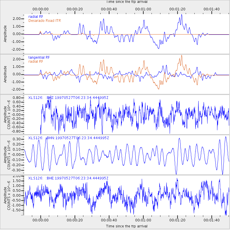
S126 Desarado Road - Earthquake Result Viewer
*The percent match for this event was below the threshold and hence no stack was calculated.
| Earthquake location: |
Pacific-Antarctic Ridge |
| Earthquake latitude/longitude: |
-54.9/-136.2 |
| Earthquake time(UTC): |
1997/05/27 (147) 06:10:31 GMT |
| Earthquake Depth: |
10 km |
| Earthquake Magnitude: |
5.9 MS, 5.3 MB, 6.1 UNKNOWN, 6.0 MW |
| Earthquake Catalog/Contributor: |
WHDF/NEIC |
|
| Network: |
XL Deep Probe (Archean-Proterozoic) |
| Station: |
S126 Desarado Road |
| Lat/Lon: |
40.19 N/108.73 W |
| Elevation: |
1761 m |
|
| Distance: |
97.6 deg |
| Az: |
20.863 deg |
| Baz: |
195.566 deg |
| Ray Param: |
$rayparam |
*The percent match for this event was below the threshold and hence was not used in the summary stack. |
|
| Radial Match: |
49.495502 % |
| Radial Bump: |
400 |
| Transverse Match: |
52.23064 % |
| Transverse Bump: |
400 |
| SOD ConfigId: |
4480 |
| Insert Time: |
2010-03-08 18:11:09.378 +0000 |
| GWidth: |
2.5 |
| Max Bumps: |
400 |
| Tol: |
0.001 |
|
Signal To Noise
| Channel | StoN | STA | LTA |
| XL:S126: :BHN:19970527T06:23:34.444995Z | 2.5811436 | 2.1711814E-7 | 8.411703E-8 |
| XL:S126: :BHE:19970527T06:23:34.444995Z | 0.9352205 | 5.949108E-7 | 6.361182E-7 |
| XL:S126: :BHZ:19970527T06:23:34.444995Z | 0.9691752 | 3.6110134E-7 | 3.7258621E-7 |
| Arrivals |
| Ps | |
| PpPs | |
| PsPs/PpSs | |


