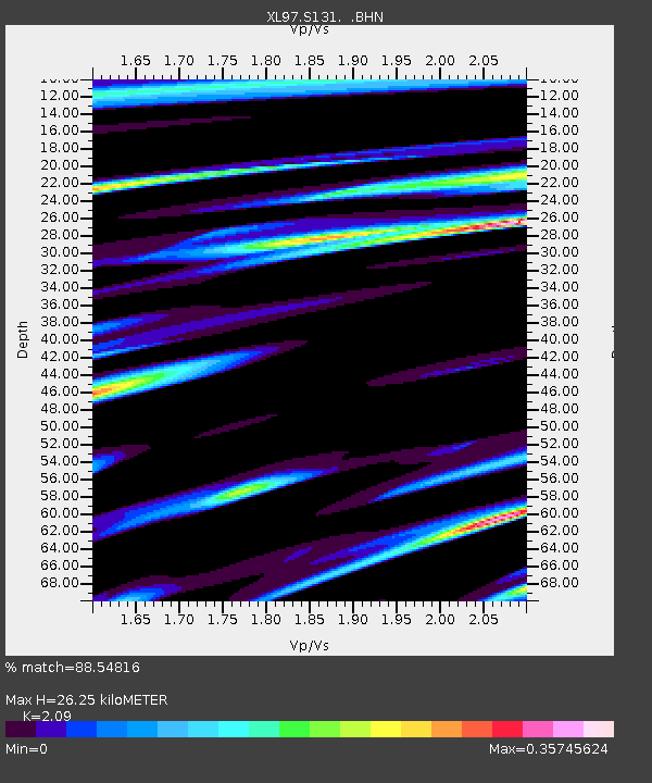
S131 Rope Canyon - Earthquake Result Viewer
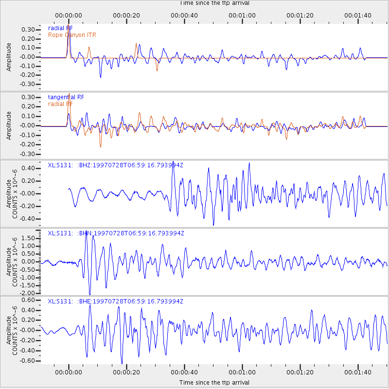
Earthquake location: Volcano Islands, Japan Region
Earthquake latitude/longitude: 22.4/142.7
Earthquake time(UTC): 1997/07/28 (209) 06:46:55 GMT
Earthquake Depth: 33 km
Earthquake Magnitude: 5.7 MB, 5.8 MS, 5.9 UNKNOWN, 5.9 MW
Earthquake Catalog/Contributor: WHDF/NEIC
Network: XL Deep Probe (Archean-Proterozoic)
Station: S131 Rope Canyon
Lat/Lon: 39.75 N/108.77 W
Elevation: 2072 m
Distance: 89.2 deg
Az: 46.989 deg
Baz: 298.599 deg
Ray Param: 0.04200215
Estimated Moho Depth: 26.25 km
Estimated Crust Vp/Vs: 2.09
Assumed Crust Vp: 6.291 km/s
Estimated Crust Vs: 3.01 km/s
Estimated Crust Poisson's Ratio: 0.35
Radial Match: 88.54816 %
Radial Bump: 400
Transverse Match: 76.80531 %
Transverse Bump: 400
SOD ConfigId: 4480
Insert Time: 2010-03-08 18:11:48.989 +0000
GWidth: 2.5
Max Bumps: 400
Tol: 0.001

Signal To Noise

ChannelStoNSTALTA
XL:S131: :BHN:19970728T06:59:16.793994Z2.47725871.6319018E-76.5875305E-8
XL:S131: :BHE:19970728T06:59:16.793994Z1.45721847.093091E-84.867555E-8
XL:S131: :BHZ:19970728T06:59:16.793994Z0.787890145.3232636E-86.7563526E-8
Arrivals
Ps4.6 SECOND
PpPs13 SECOND
PsPs/PpSs17 SECOND