
Station XL S131 - Rope Canyon
Network: XL97 - Deep Probe (Archean-Proterozoic)
Nearby stations (2 deg radius)
| Station | Name | (Lat, Lon) | Start / End | Elevation |
| S131 | Rope Canyon | (39.75, -108.77) | 1997-05-06 / 1997-12-31 | 2072 m |
| Crust2 Type: | Q3,orogen/43km no ice, Appalachians, 3 km seds. |
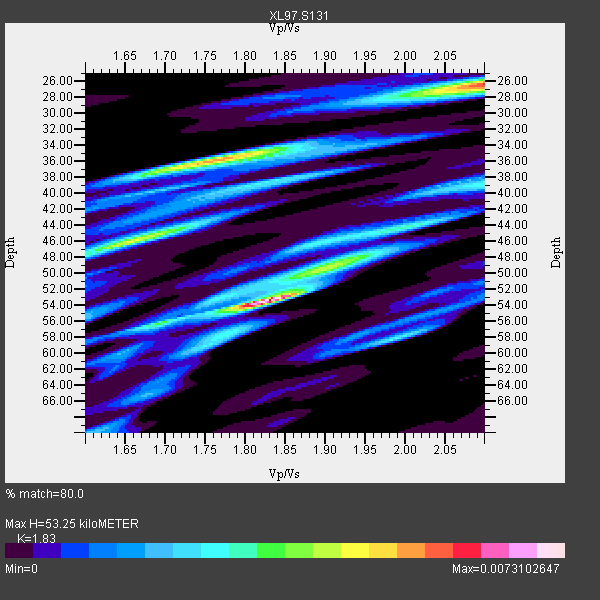
| Thickness Estimate: | 53 km |
| Thickness StdDev: | 11 km |
| Vp/Vs Estimate: | 1.83 |
| Vp/Vs StdDev: | 0.16 |
| Vs Estimate: | 3.438 km/s |
| Poisson's Ratio: | 0.29 |
| Peak Value: | 0.01 |
| Assumed Vp: | 6.291 km/s |
| Ps Weight: | 0.33333334 |
| PpPs Weight: | 0.33333334 |
| PsPs Weight: | 0.33333328 |
| Residual Complexity: | 0.822 |
| Nearby stations H: | +- |
| (2.0 deg) Vp/Vs: | +- |
4 with match > 90% ( 18.181818 %) and 7 with match > 80% ( 31.818182 %) out of 22.
Download stack as xyz text file.
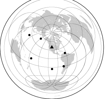
Azimuth Distribution of Events:
Prior Results for this Station
| Study | Thickness | Vp/Vs | Vp | Vs | Poissons Ratio | Extra |
| EARS | 53 km | 1.83 | 6.291 km/s | 3.438 km/s | 0.29 | |
| Crust2.0 | 43 km | 1.76 | 6.291 km/s | 3.577 km/s | 0.26 | Q3,orogen/43km no ice, Appalachians, 3 km seds. |
| Global Maxima | 53 km | 1.83 | 6.291 km/s | 3.438 km/s | 0.29 | amp=0.0073102647 |
| Local Maxima 1 | 26 km | 2.10 | 6.291 km/s | 2.999 km/s | 0.35 | amp=0.0058824914 |
| Local Maxima 2 | 36 km | 1.75 | 6.291 km/s | 3.595 km/s | 0.26 | amp=0.004938594 |
| Local Maxima 3 | 46 km | 1.68 | 6.291 km/s | 3.756 km/s | 0.22 | amp=0.0041631395 |
| Local Maxima 4 | 49 km | 1.92 | 6.291 km/s | 3.276 km/s | 0.31 | amp=0.0032936938 |
| Predicted Arrivals for vertical incidence (zero ray parameter) | |
| Ps | 7.03 SECOND |
| PpPs | 23.96 SECOND |
| PsPs/PpSs | 30.98 SECOND |
Events Processed for this Station
Download zip of receiver functions as SAC
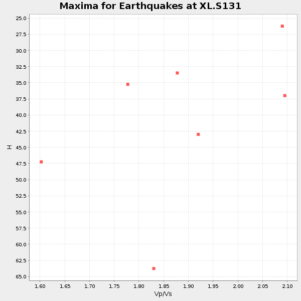
Plot maxima for each earthquake.
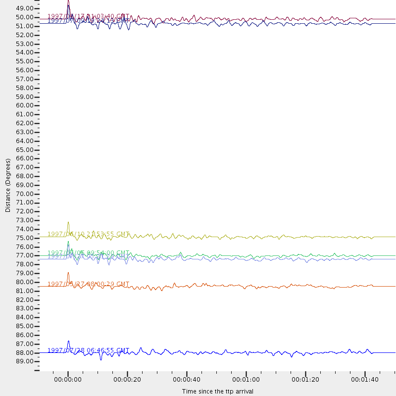
Events Used in the Stack
(7 events)| Radial Match | Distance | Baz | FERegion | Time | Lat/Lon | Depth | Magnitude |
| 93.28747 | 77.9 deg | 147.989 deg | Near Coast Of Central Chile | 1997/07/27 05:21:29 GMT | (-30.5, -71.9) | 33 km | 5.6 MB, 5.8 MS, 6.3 UNKNOWN, 6.2 MW |
| 91.7358 | 49.5 deg | 113.217 deg | Near Coast Of Venezuela | 1997/07/09 19:24:13 GMT | (10.6, -63.5) | 20 km | 6.2 MB, 6.8 MS, 7.0 UNKNOWN, 6.6 ME |
| 91.005 | 77.5 deg | 147.775 deg | Near Coast Of Central Chile | 1997/07/06 09:54:00 GMT | (-30.1, -71.9) | 19 km | 5.8 MB, 6.5 MS, 6.8 UNKNOWN, 6.4 ME |
| 90.52448 | 48.9 deg | 308.331 deg | Andreanof Islands, Aleutian Is. | 1997/06/17 21:03:40 GMT | (51.3, -179.3) | 33 km | 6.4 MB, 6.3 MS, 6.4 UNKNOWN, 6.6 ML |
| 88.54816 | 89.2 deg | 298.599 deg | Volcano Islands, Japan Region | 1997/07/28 06:46:55 GMT | (22.4, 142.7) | 33 km | 5.7 MB, 5.8 MS, 5.9 UNKNOWN, 5.9 MW |
| 87.47365 | 75.2 deg | 179.467 deg | Southern East Pacific Rise | 1997/06/10 21:53:55 GMT | (-35.8, -108.1) | 10 km | 5.8 MB, 6.1 MS, 6.5 UNKNOWN, 5.8 MS |
| 83.69275 | 81.2 deg | 241.917 deg | Tonga Islands | 1997/05/27 08:00:29 GMT | (-15.2, -173.3) | 14 km | 5.6 MB, 6.3 MS, 6.4 UNKNOWN, 5.7 ME |
Losers
(15 events)| Radial Match | Distance | Baz | FERegion | Time | Lat/Lon | Depth | Magnitude | Reason |
| 79.752396 | 41.5 deg | 308.077 deg | Fox Islands, Aleutian Islands | 1997/07/20 00:30:20 GMT | (52.6, -167.5) | 14 km | 5.6 MB, 5.9 MS, 6.2 UNKNOWN, 6.2 MW | |
| 77.64125 | 43.6 deg | 307.249 deg | Fox Islands, Aleutian Islands | 1997/05/08 13:29:24 GMT | (51.7, -170.8) | 33 km | 5.8 MB, 5.9 MS, 6.0 UNKNOWN, 6.0 MW | |
| 75.702385 | 76.9 deg | 147.25 deg | Near Coast Of Central Chile | 1997/07/19 12:22:57 GMT | (-29.3, -71.7) | 26 km | 5.8 MB, 5.5 MS, 5.9 UNKNOWN, 5.8 MW | |
| 73.22927 | 77.8 deg | 147.997 deg | Near Coast Of Central Chile | 1997/07/25 06:47:02 GMT | (-30.5, -71.9) | 33 km | 5.6 MB, 5.5 MS, 6.3 UNKNOWN | |
| 71.671104 | 96.9 deg | 249.275 deg | Vanuatu Islands | 1997/05/21 14:10:26 GMT | (-20.4, 169.3) | 57 km | 5.9 MB, 6.5 MS, 6.7 UNKNOWN, 6.1 ME | |
| 68.840805 | 73.9 deg | 139.644 deg | Jujuy Province, Argentina | 1997/07/20 10:14:22 GMT | (-23.0, -66.3) | 256 km | 5.7 MB, 6.1 UNKNOWN, 5.7 ME | |
| 68.74603 | 73.1 deg | 312.431 deg | Kuril Islands | 1997/07/14 16:09:35 GMT | (43.2, 146.4) | 33 km | 5.9 MB, 5.8 MS, 6.1 UNKNOWN, 5.8 ME | |
| 67.812225 | 48.5 deg | 308.2 deg | Andreanof Islands, Aleutian Is. | 1997/07/08 12:11:15 GMT | (51.4, -178.6) | 33 km | 5.5 MB, 5.4 MS, 5.8 UNKNOWN, 5.6 ML | |
| 61.916992 | 88.2 deg | 299.672 deg | Volcano Islands, Japan Region | 1997/07/08 02:24:07 GMT | (23.8, 142.7) | 33 km | 5.8 MB, 5.6 MS, 5.9 UNKNOWN, 5.8 MW | |
| 59.951694 | 97.9 deg | 311.753 deg | Southwestern Ryukyu Isl., Japan | 1997/08/13 04:45:04 GMT | (25.0, 125.8) | 55 km | 6.0 MB, 5.6 MS, 6.1 UNKNOWN, 6.1 MW | |
| 55.264683 | 89.2 deg | 183.764 deg | Southern East Pacific Rise | 1997/06/26 19:21:08 GMT | (-49.7, -114.6) | 10 km | 5.4 MB, 6.0 MS, 6.2 UNKNOWN, 6.1 MW | |
| 49.699444 | 90.1 deg | 238.486 deg | South Of Fiji Islands | 1997/06/11 09:29:23 GMT | (-24.0, -177.5) | 164 km | 5.9 UNKNOWN, 5.4 MB, 5.5 MB | |
| 39.309097 | 91.3 deg | 292.449 deg | Mariana Islands | 1997/05/27 15:09:03 GMT | (16.3, 145.4) | 536 km | 5.5 MB, 5.6 UNKNOWN, 5.6 MW | |
| 37.012856 | 86.7 deg | 243.769 deg | Fiji Islands Region | 1997/06/11 11:53:32 GMT | (-17.8, -178.8) | 573 km | 5.5 UNKNOWN, 4.9 MB | |
| 36.866184 | 91.9 deg | 38.777 deg | Central Mediterranean Sea | 1997/07/27 10:07:52 GMT | (35.6, 21.1) | 33 km | 5.5 MB, 4.8 MS, 5.6 UNKNOWN, 5.2 ML |
