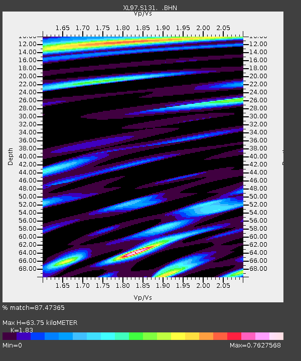
S131 Rope Canyon - Earthquake Result Viewer
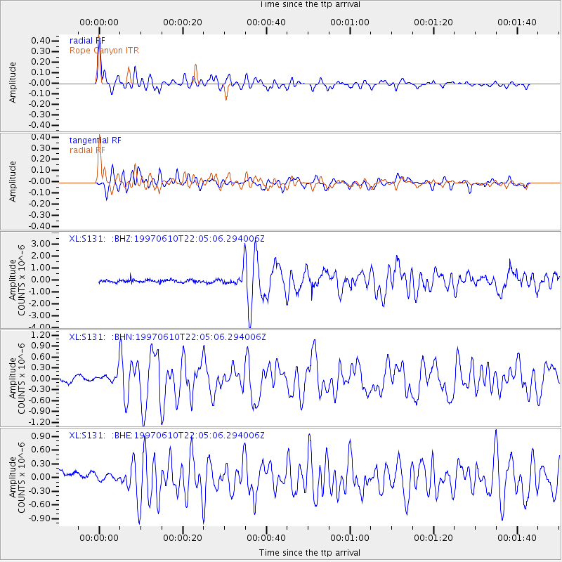
Earthquake location: Southern East Pacific Rise
Earthquake latitude/longitude: -35.8/-108.1
Earthquake time(UTC): 1997/06/10 (161) 21:53:55 GMT
Earthquake Depth: 10 km
Earthquake Magnitude: 5.8 MB, 6.1 MS, 6.5 UNKNOWN, 5.8 MS
Earthquake Catalog/Contributor: WHDF/NEIC
Network: XL Deep Probe (Archean-Proterozoic)
Station: S131 Rope Canyon
Lat/Lon: 39.75 N/108.77 W
Elevation: 2072 m
Distance: 75.2 deg
Az: 359.494 deg
Baz: 179.467 deg
Ray Param: 0.051831704
Estimated Moho Depth: 63.75 km
Estimated Crust Vp/Vs: 1.83
Assumed Crust Vp: 6.291 km/s
Estimated Crust Vs: 3.438 km/s
Estimated Crust Poisson's Ratio: 0.29
Radial Match: 87.47365 %
Radial Bump: 400
Transverse Match: 74.84126 %
Transverse Bump: 400
SOD ConfigId: 6273
Insert Time: 2010-03-08 18:11:51.029 +0000
GWidth: 2.5
Max Bumps: 400
Tol: 0.001

Signal To Noise

ChannelStoNSTALTA
XL:S131: :BHN:19970610T22:05:06.294006Z2.7168952.1884469E-78.054956E-8
XL:S131: :BHE:19970610T22:05:06.294006Z0.627721671.256025E-72.0009267E-7
XL:S131: :BHZ:19970610T22:05:06.294006Z5.42902475.8756837E-71.0822725E-7
Arrivals
Ps8.7 SECOND
PpPs28 SECOND
PsPs/PpSs36 SECOND