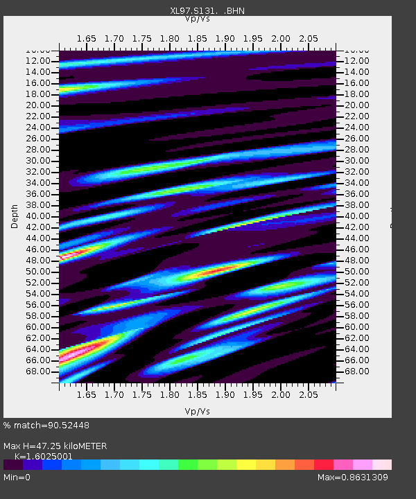
S131 Rope Canyon - Earthquake Result Viewer
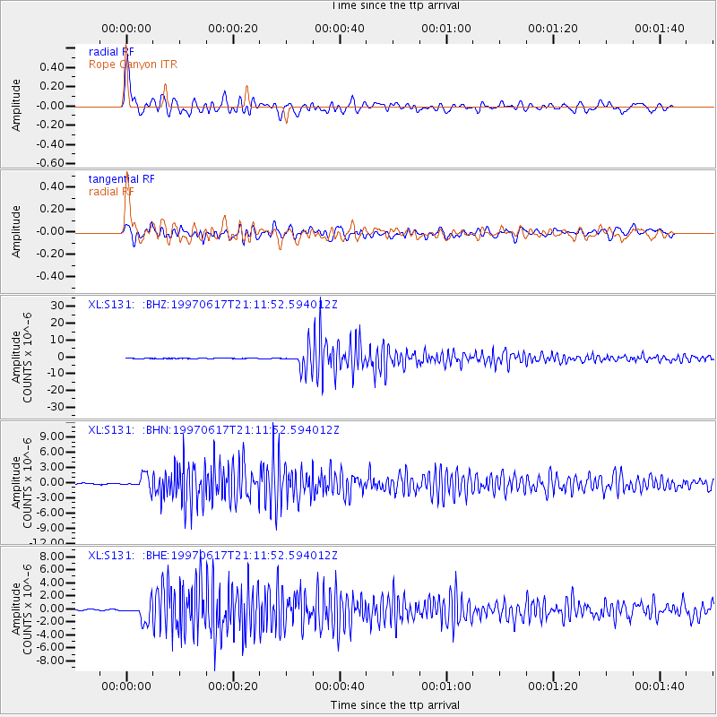
Earthquake location: Andreanof Islands, Aleutian Is.
Earthquake latitude/longitude: 51.3/-179.3
Earthquake time(UTC): 1997/06/17 (168) 21:03:40 GMT
Earthquake Depth: 33 km
Earthquake Magnitude: 6.4 MB, 6.3 MS, 6.4 UNKNOWN, 6.6 ML
Earthquake Catalog/Contributor: WHDF/NEIC
Network: XL Deep Probe (Archean-Proterozoic)
Station: S131 Rope Canyon
Lat/Lon: 39.75 N/108.77 W
Elevation: 2072 m
Distance: 48.9 deg
Az: 74.649 deg
Baz: 308.331 deg
Ray Param: 0.06896609
Estimated Moho Depth: 47.25 km
Estimated Crust Vp/Vs: 1.60
Assumed Crust Vp: 6.291 km/s
Estimated Crust Vs: 3.926 km/s
Estimated Crust Poisson's Ratio: 0.18
Radial Match: 90.52448 %
Radial Bump: 400
Transverse Match: 80.46114 %
Transverse Bump: 400
SOD ConfigId: 6273
Insert Time: 2010-03-08 18:11:52.361 +0000
GWidth: 2.5
Max Bumps: 400
Tol: 0.001

Signal To Noise

ChannelStoNSTALTA
XL:S131: :BHN:19970617T21:11:52.594012Z13.247111.3756609E-61.03846105E-7
XL:S131: :BHE:19970617T21:11:52.594012Z11.9403931.3301484E-61.1139904E-7
XL:S131: :BHZ:19970617T21:11:52.594012Z69.596576.1027763E-68.768788E-8
Arrivals
Ps4.8 SECOND
PpPs18 SECOND
PsPs/PpSs23 SECOND