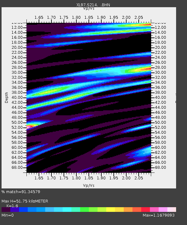
S214 Birch Spring Draw - Earthquake Result Viewer
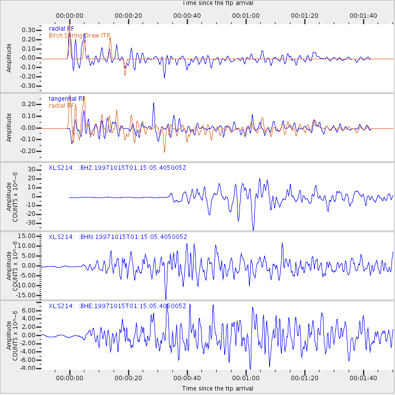
Earthquake location: Near Coast Of Central Chile
Earthquake latitude/longitude: -30.9/-71.2
Earthquake time(UTC): 1997/10/15 (288) 01:03:33 GMT
Earthquake Depth: 58 km
Earthquake Magnitude: 6.8 MB, 6.8 MS, 7.3 UNKNOWN, 7.1 MW
Earthquake Catalog/Contributor: WHDF/NEIC
Network: XL Deep Probe (Archean-Proterozoic)
Station: S214 Birch Spring Draw
Lat/Lon: 40.97 N/109.86 W
Elevation: 2377 m
Distance: 80.0 deg
Az: 331.299 deg
Baz: 146.98 deg
Ray Param: 0.048486136
Estimated Moho Depth: 51.75 km
Estimated Crust Vp/Vs: 1.60
Assumed Crust Vp: 6.207 km/s
Estimated Crust Vs: 3.879 km/s
Estimated Crust Poisson's Ratio: 0.18
Radial Match: 91.34579 %
Radial Bump: 400
Transverse Match: 84.01238 %
Transverse Bump: 400
SOD ConfigId: 6273
Insert Time: 2010-03-08 18:14:08.421 +0000
GWidth: 2.5
Max Bumps: 400
Tol: 0.001

Signal To Noise

ChannelStoNSTALTA
XL:S214: :BHN:19971015T01:15:05.405005Z1.29120062.8115028E-72.1774329E-7
XL:S214: :BHE:19971015T01:15:05.405005Z2.044322.3875543E-71.1678966E-7
XL:S214: :BHZ:19971015T01:15:05.405005Z6.1141141.3766248E-62.2515525E-7
Arrivals
Ps5.2 SECOND
PpPs21 SECOND
PsPs/PpSs26 SECOND