
Station XL S214 - Birch Spring Draw
Network: XL97 - Deep Probe (Archean-Proterozoic)
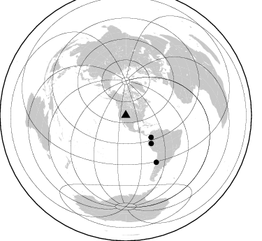
Nearby stations (2 deg radius)
| Station | Name | (Lat, Lon) | Start / End | Elevation |
| S214 | Birch Spring Draw | (40.97, -109.86) | 1997-08-19 / 1997-12-31 | 2377 m |
| Crust2 Type: | Q4,orogen/43km no ice, Tethian Belt, 5 km seds. |
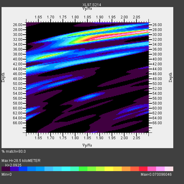
| Thickness Estimate: | 28 km |
| Thickness StdDev: | 5.4 km |
| Vp/Vs Estimate: | 2.09 |
| Vp/Vs StdDev: | 0.17 |
| Vs Estimate: | 2.966 km/s |
| Poisson's Ratio: | 0.35 |
| Peak Value: | 0.07 |
| Assumed Vp: | 6.207 km/s |
| Ps Weight: | 0.33333334 |
| PpPs Weight: | 0.33333334 |
| PsPs Weight: | 0.33333328 |
| Residual Complexity: | 0.747 |
| Nearby stations H: | +- |
| (2.0 deg) Vp/Vs: | +- |
3 with match > 90% ( 33.333332 %) and 3 with match > 80% ( 33.333332 %) out of 9.
Download stack as xyz text file.
Azimuth Distribution of Events:
Prior Results for this Station
| Study | Thickness | Vp/Vs | Vp | Vs | Poissons Ratio | Extra |
| EARS | 28 km | 2.09 | 6.207 km/s | 2.966 km/s | 0.35 | |
| Crust2.0 | 43 km | 1.76 | 6.207 km/s | 3.535 km/s | 0.26 | Q4,orogen/43km no ice, Tethian Belt, 5 km seds. |
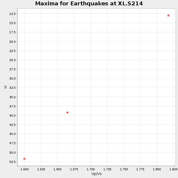
| Global Maxima | 28 km | 2.09 | 6.207 km/s | 2.966 km/s | 0.35 | amp=0.070096046 |
| Local Maxima 1 | 32 km | 1.87 | 6.207 km/s | 3.315 km/s | 0.30 | amp=0.052756898 |
| Local Maxima 2 | 28 km | 1.89 | 6.207 km/s | 3.288 km/s | 0.30 | amp=0.046856828 |
| Local Maxima 3 | 39 km | 1.68 | 6.207 km/s | 3.689 km/s | 0.23 | amp=0.04367709 |
| Local Maxima 4 | 44 km | 1.60 | 6.207 km/s | 3.873 km/s | 0.18 | amp=0.031339817 |
| Predicted Arrivals for vertical incidence (zero ray parameter) | |
| Ps | 5.02 SECOND |
| PpPs | 14.20 SECOND |
| PsPs/PpSs | 19.22 SECOND |
Events Processed for this Station
Download zip of receiver functions as SAC
Plot maxima for each earthquake.
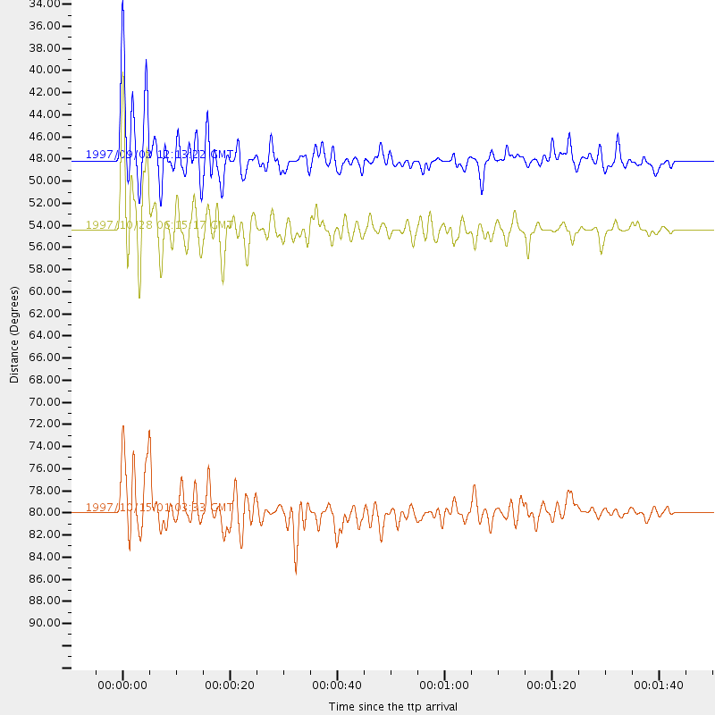
Events Used in the Stack
(3 events)| Radial Match | Distance | Baz | FERegion | Time | Lat/Lon | Depth | Magnitude |
| 92.04907 | 48.0 deg | 131.149 deg | Colombia | 1997/09/02 12:13:22 GMT | (3.8, -75.7) | 199 km | 6.5 MB, 6.8 UNKNOWN, 6.4 ME |
| 91.34579 | 80.0 deg | 146.98 deg | Near Coast Of Central Chile | 1997/10/15 01:03:33 GMT | (-30.9, -71.2) | 58 km | 6.8 MB, 6.8 MS, 7.3 UNKNOWN, 7.1 MW |
| 91.014175 | 54.4 deg | 137.821 deg | Northern Peru | 1997/10/28 06:15:17 GMT | (-4.4, -76.7) | 112 km | 6.6 MB, 6.3 MS, 7.2 UNKNOWN, 6.6 ME |
Losers
(6 events)| Radial Match | Distance | Baz | FERegion | Time | Lat/Lon | Depth | Magnitude | Reason |
| 73.18191 | 86.1 deg | 237.507 deg | Tonga Islands | 1997/09/10 12:57:07 GMT | (-21.3, -174.4) | 10 km | 5.7 MB, 6.1 MS, 6.1 UNKNOWN, 5.9 MW | |
| 70.29205 | 93.4 deg | 234.562 deg | Kermadec Islands Region | 1997/09/20 16:11:32 GMT | (-28.7, -177.6) | 30 km | 6.1 MB, 7.0 MS, 7.2 UNKNOWN, 6.7 ME | |
| 67.86162 | 73.9 deg | 140.41 deg | Northern Chile | 1997/09/28 23:13:13 GMT | (-22.4, -68.4) | 107 km | 5.7 MB, 5.6 UNKNOWN, 5.6 MW | |
| 58.60368 | 88.7 deg | 240.814 deg | Fiji Islands Region | 1997/10/17 15:02:00 GMT | (-20.9, -178.8) | 579 km | 5.3 MB, 6.0 UNKNOWN, 6.0 MW | |
| 52.70341 | 94.5 deg | 238.587 deg | South Of Fiji Islands | 1997/09/04 04:23:37 GMT | (-26.6, 178.3) | 625 km | 6.3 MB, 6.8 UNKNOWN, 6.5 ME | |
| 40.548805 | 97.2 deg | 190.915 deg | Pacific-Antarctic Ridge | 1997/09/03 06:22:44 GMT | (-55.2, -129.0) | 10 km | 5.1 MB, 6.0 MS, 6.1 UNKNOWN, 6.0 MW |
