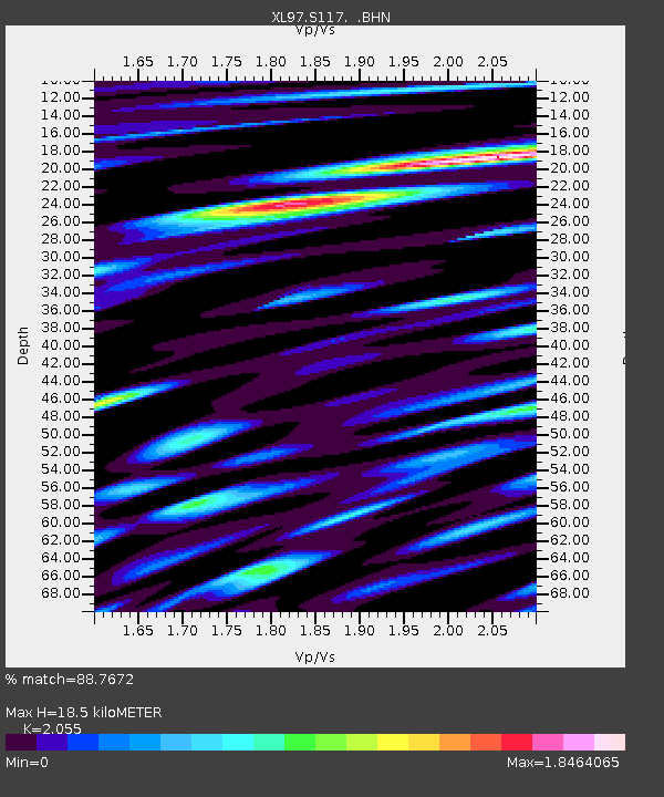
S117 Milepost 54 - Earthquake Result Viewer
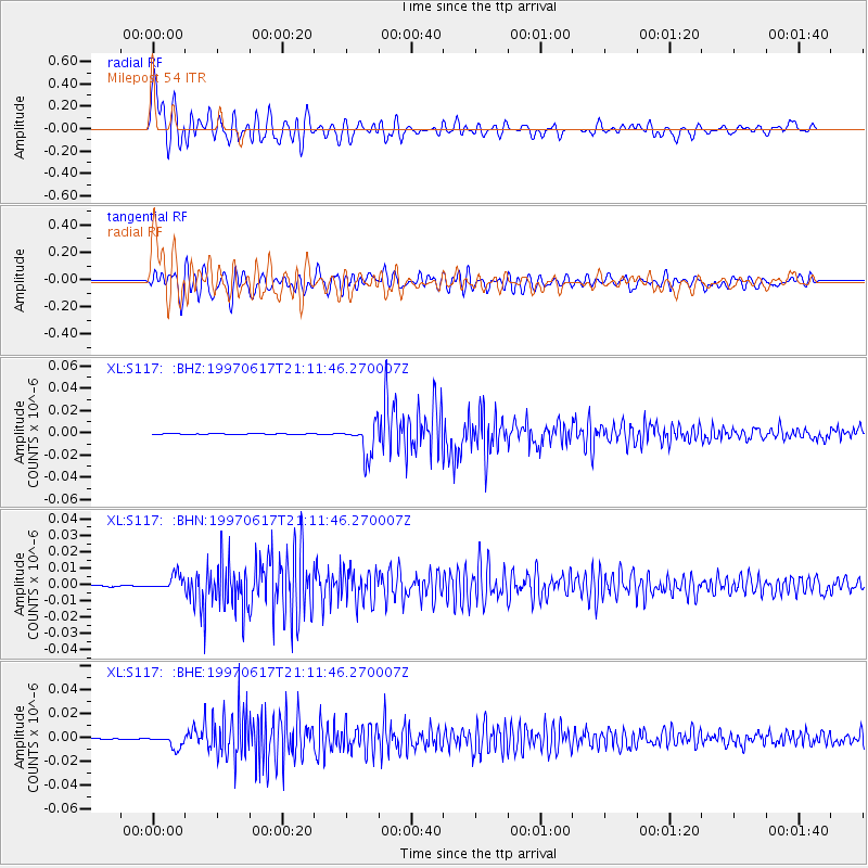
Earthquake location: Andreanof Islands, Aleutian Is.
Earthquake latitude/longitude: 51.3/-179.3
Earthquake time(UTC): 1997/06/17 (168) 21:03:40 GMT
Earthquake Depth: 33 km
Earthquake Magnitude: 6.4 MB, 6.3 MS, 6.4 UNKNOWN, 6.6 ML
Earthquake Catalog/Contributor: WHDF/NEIC
Network: XL Deep Probe (Archean-Proterozoic)
Station: S117 Milepost 54
Lat/Lon: 41.02 N/108.83 W
Elevation: 2195 m
Distance: 48.1 deg
Az: 73.355 deg
Baz: 307.432 deg
Ray Param: 0.06950296
Estimated Moho Depth: 18.5 km
Estimated Crust Vp/Vs: 2.06
Assumed Crust Vp: 6.207 km/s
Estimated Crust Vs: 3.02 km/s
Estimated Crust Poisson's Ratio: 0.34
Radial Match: 88.7672 %
Radial Bump: 400
Transverse Match: 79.732155 %
Transverse Bump: 400
SOD ConfigId: 6273
Insert Time: 2010-03-08 18:15:06.841 +0000
GWidth: 2.5
Max Bumps: 400
Tol: 0.001

Signal To Noise

ChannelStoNSTALTA
XL:S117: :BHN:19970617T21:11:46.270007Z10.0226574.61141E-94.6009854E-10
XL:S117: :BHE:19970617T21:11:46.270007Z10.8416435.5535794E-95.1224514E-10
XL:S117: :BHZ:19970617T21:11:46.270007Z50.418741.3958084E-82.7684316E-10
Arrivals
Ps3.3 SECOND
PpPs8.7 SECOND
PsPs/PpSs12 SECOND