
Station XL S117 - Milepost 54
Network: XL97 - Deep Probe (Archean-Proterozoic)
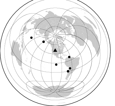
Nearby stations (2 deg radius)
| Station | Name | (Lat, Lon) | Start / End | Elevation |
| S117 | Milepost 54 | (41.02, -108.83) | 1997-05-14 / 1997-12-31 | 2195 m |
| Crust2 Type: | Q4,orogen/43km no ice, Tethian Belt, 5 km seds. |
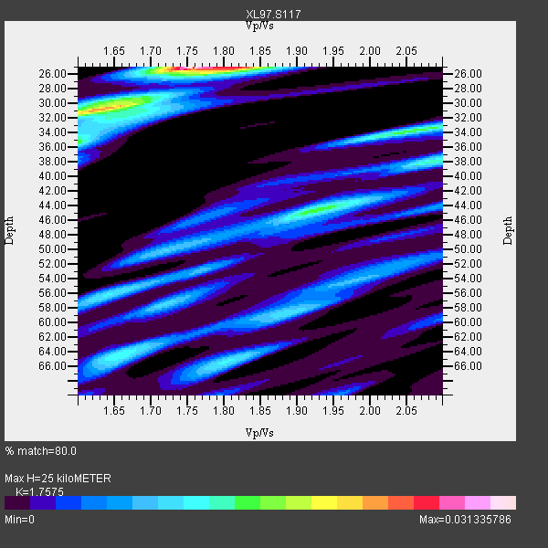
| Thickness Estimate: | 25 km |
| Thickness StdDev: | 7.5 km |
| Vp/Vs Estimate: | 1.76 |
| Vp/Vs StdDev: | 0.08 |
| Vs Estimate: | 3.532 km/s |
| Poisson's Ratio: | 0.26 |
| Peak Value: | 0.03 |
| Assumed Vp: | 6.207 km/s |
| Ps Weight: | 0.33333334 |
| PpPs Weight: | 0.33333334 |
| PsPs Weight: | 0.33333328 |
| Residual Complexity: | 0.845 |
| Nearby stations H: | +- |
| (2.0 deg) Vp/Vs: | +- |
4 with match > 90% ( 21.052631 %) and 9 with match > 80% ( 47.36842 %) out of 19.
Download stack as xyz text file.
Azimuth Distribution of Events:
Prior Results for this Station
| Study | Thickness | Vp/Vs | Vp | Vs | Poissons Ratio | Extra |
| EARS | 25 km | 1.76 | 6.207 km/s | 3.532 km/s | 0.26 | |
| Crust2.0 | 43 km | 1.76 | 6.207 km/s | 3.535 km/s | 0.26 | Q4,orogen/43km no ice, Tethian Belt, 5 km seds. |
| Global Maxima | 25 km | 1.76 | 6.207 km/s | 3.532 km/s | 0.26 | amp=0.031335786 |
| Local Maxima 1 | 31 km | 1.65 | 6.207 km/s | 3.768 km/s | 0.21 | amp=0.016928125 |
| Local Maxima 2 | 34 km | 2.07 | 6.207 km/s | 2.995 km/s | 0.35 | amp=0.015427842 |
| Local Maxima 3 | 44 km | 1.92 | 6.207 km/s | 3.224 km/s | 0.32 | amp=0.015068033 |
| Local Maxima 4 | 64 km | 1.67 | 6.207 km/s | 3.717 km/s | 0.22 | amp=0.012404103 |
| Predicted Arrivals for vertical incidence (zero ray parameter) | |
| Ps | 3.05 SECOND |
| PpPs | 11.11 SECOND |
| PsPs/PpSs | 14.16 SECOND |
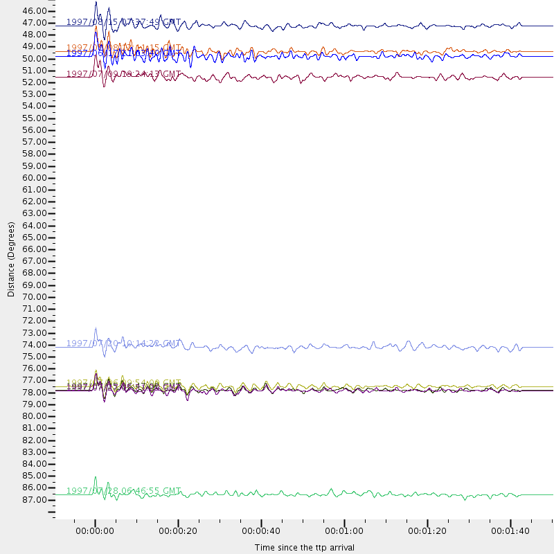
Events Processed for this Station
Download zip of receiver functions as SAC
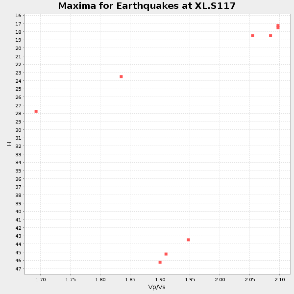
Plot maxima for each earthquake.
Events Used in the Stack
(9 events)| Radial Match | Distance | Baz | FERegion | Time | Lat/Lon | Depth | Magnitude |
| 94.02489 | 78.6 deg | 147.868 deg | Near Coast Of Central Chile | 1997/07/06 09:54:00 GMT | (-30.1, -71.9) | 19 km | 5.8 MB, 6.5 MS, 6.8 UNKNOWN, 6.4 ME |
| 93.95174 | 45.3 deg | 175.595 deg | Central East Pacific Rise | 1997/08/15 07:37:49 GMT | (-4.4, -105.7) | 10 km | 5.3 MB, 5.8 MS, 6.2 UNKNOWN, 6.1 MW |
| 93.78596 | 79.0 deg | 148.076 deg | Near Coast Of Central Chile | 1997/07/27 05:21:29 GMT | (-30.5, -71.9) | 33 km | 5.6 MB, 5.8 MS, 6.3 UNKNOWN, 6.2 MW |
| 90.17244 | 50.0 deg | 114.14 deg | Near Coast Of Venezuela | 1997/07/09 19:24:13 GMT | (10.6, -63.5) | 20 km | 6.2 MB, 6.8 MS, 7.0 UNKNOWN, 6.6 ME |
| 88.7672 | 48.1 deg | 307.432 deg | Andreanof Islands, Aleutian Is. | 1997/06/17 21:03:40 GMT | (51.3, -179.3) | 33 km | 6.4 MB, 6.3 MS, 6.4 UNKNOWN, 6.6 ML |
| 86.30197 | 78.9 deg | 148.085 deg | Near Coast Of Central Chile | 1997/07/25 06:47:02 GMT | (-30.5, -71.9) | 33 km | 5.6 MB, 5.5 MS, 6.3 UNKNOWN |
| 82.66079 | 74.9 deg | 139.82 deg | Jujuy Province, Argentina | 1997/07/20 10:14:22 GMT | (-23.0, -66.3) | 256 km | 5.7 MB, 6.1 UNKNOWN, 5.7 ME |
| 82.650665 | 47.7 deg | 307.285 deg | Andreanof Islands, Aleutian Is. | 1997/07/08 12:11:15 GMT | (51.4, -178.6) | 33 km | 5.5 MB, 5.4 MS, 5.8 UNKNOWN, 5.6 ML |
| 81.126564 | 88.5 deg | 298.535 deg | Volcano Islands, Japan Region | 1997/07/28 06:46:55 GMT | (22.4, 142.7) | 33 km | 5.7 MB, 5.8 MS, 5.9 UNKNOWN, 5.9 MW |
Losers
(10 events)| Radial Match | Distance | Baz | FERegion | Time | Lat/Lon | Depth | Magnitude | Reason |
| 77.90762 | 81.7 deg | 241.703 deg | Tonga Islands | 1997/05/27 08:00:29 GMT | (-15.2, -173.3) | 14 km | 5.6 MB, 6.3 MS, 6.4 UNKNOWN, 5.7 ME | |
| 75.478325 | 87.5 deg | 299.59 deg | Volcano Islands, Japan Region | 1997/07/08 02:24:07 GMT | (23.8, 142.7) | 33 km | 5.8 MB, 5.6 MS, 5.9 UNKNOWN, 5.8 MW | |
| 72.56723 | 77.9 deg | 147.352 deg | Near Coast Of Central Chile | 1997/07/19 12:22:57 GMT | (-29.3, -71.7) | 26 km | 5.8 MB, 5.5 MS, 5.9 UNKNOWN, 5.8 MW | |
| 56.875385 | 94.0 deg | 246.124 deg | Vanuatu Islands Region | 1997/06/24 16:17:09 GMT | (-20.7, 174.2) | 33 km | 5.5 MS, 5.2 MB, 5.9 UNKNOWN, 5.9 MW | |
| 56.182446 | 90.8 deg | 292.429 deg | Mariana Islands | 1997/05/27 15:09:03 GMT | (16.3, 145.4) | 536 km | 5.5 MB, 5.6 UNKNOWN, 5.6 MW | |
| 51.78791 | 97.3 deg | 249.382 deg | Vanuatu Islands | 1997/05/21 14:10:26 GMT | (-20.4, 169.3) | 57 km | 5.9 MB, 6.5 MS, 6.7 UNKNOWN, 6.1 ME | |
| 51.62248 | 30.7 deg | 137.74 deg | Caribbean Sea | 1997/07/06 20:13:37 GMT | (16.2, -87.9) | 33 km | 5.5 MB, 5.5 MS, 6.0 UNKNOWN, 5.9 MW | |
| 50.091187 | 97.0 deg | 311.831 deg | Southwestern Ryukyu Isl., Japan | 1997/08/13 04:45:04 GMT | (25.0, 125.8) | 55 km | 6.0 MB, 5.6 MS, 6.1 UNKNOWN, 6.1 MW | |
| 44.388653 | 97.6 deg | 248.115 deg | Southeast Of Loyalty Islands | 1997/05/15 18:01:33 GMT | (-21.6, 169.9) | 33 km | 5.3 MB, 5.6 MS, 6.0 UNKNOWN, 5.9 MW | |
| 41.539997 | 91.0 deg | 38.714 deg | Central Mediterranean Sea | 1997/07/27 10:07:52 GMT | (35.6, 21.1) | 33 km | 5.5 MB, 4.8 MS, 5.6 UNKNOWN, 5.2 ML |
