You are here: Home > Network List > XL97 - Deep Probe (Archean-Proterozoic) Stations List
> Station S201 Cokeville > Earthquake Result Viewer
S201 Cokeville - Earthquake Result Viewer
| Earthquake location: |
Colombia |
| Earthquake latitude/longitude: |
3.8/-75.7 |
| Earthquake time(UTC): |
1997/09/02 (245) 12:13:22 GMT |
| Earthquake Depth: |
199 km |
| Earthquake Magnitude: |
6.5 MB, 6.8 UNKNOWN, 6.4 ME |
| Earthquake Catalog/Contributor: |
WHDF/NEIC |
|
| Network: |
XL Deep Probe (Archean-Proterozoic) |
| Station: |
S201 Cokeville |
| Lat/Lon: |
42.02 N/110.90 W |
| Elevation: |
1929 m |
|
| Distance: |
49.3 deg |
| Az: |
325.525 deg |
| Baz: |
130.713 deg |
| Ray Param: |
0.06807624 |
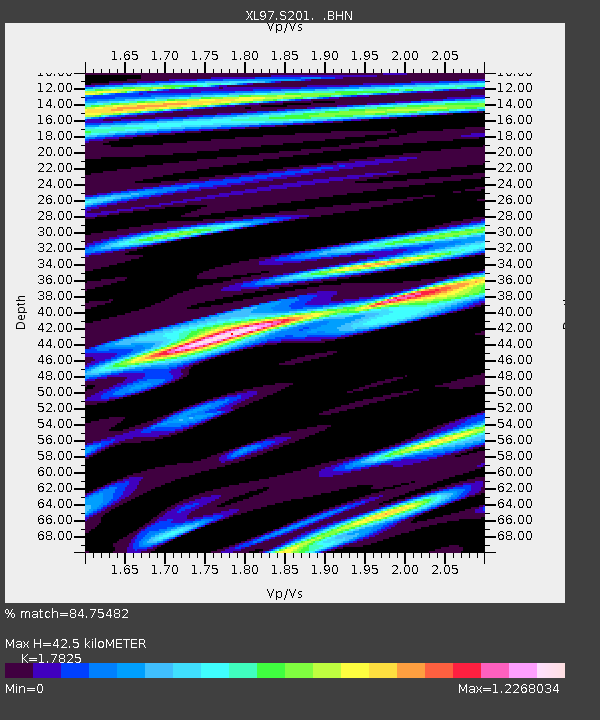
| Estimated Moho Depth: |
42.5 km |
| Estimated Crust Vp/Vs: |
1.78 |
| Assumed Crust Vp: |
6.207 km/s |
| Estimated Crust Vs: |
3.482 km/s |
| Estimated Crust Poisson's Ratio: |
0.27 |
|
| Radial Match: |
84.75482 % |
| Radial Bump: |
400 |
| Transverse Match: |
81.177086 % |
| Transverse Bump: |
400 |
| SOD ConfigId: |
6273 |
| Insert Time: |
2010-03-08 18:17:08.827 +0000 |
| GWidth: |
2.5 |
| Max Bumps: |
400 |
| Tol: |
0.001 |
|

Signal To Noise
| Channel | StoN | STA | LTA |
| XL:S201: :BHN:19970902T12:21:20.888007Z | 13.336121 | 1.2474386E-6 | 9.353835E-8 |
| XL:S201: :BHE:19970902T12:21:20.888007Z | 18.302176 | 2.0910934E-6 | 1.14253815E-7 |
| XL:S201: :BHZ:19970902T12:21:20.888007Z | 74.14289 | 4.8717325E-6 | 6.570734E-8 |
| Arrivals |
| Ps | 5.7 SECOND |
| PpPs | 18 SECOND |
| PsPs/PpSs | 24 SECOND |


