
Station XL S201 - Cokeville
Network: XL97 - Deep Probe (Archean-Proterozoic)
Nearby stations (2 deg radius)
| Station | Name | (Lat, Lon) | Start / End | Elevation |
| S201 | Cokeville | (42.02, -110.90) | 1997-08-14 / 1997-12-31 | 1929 m |
| Crust2 Type: | M8,thick extended crust, 1.5 km seds. |
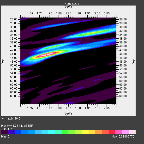
| Thickness Estimate: | 44 km |
| Thickness StdDev: | 3.5 km |
| Vp/Vs Estimate: | 1.74 |
| Vp/Vs StdDev: | 0.07 |
| Vs Estimate: | 3.577 km/s |
| Poisson's Ratio: | 0.25 |
| Peak Value: | 0.09 |
| Assumed Vp: | 6.207 km/s |
| Ps Weight: | 0.33333334 |
| PpPs Weight: | 0.33333334 |
| PsPs Weight: | 0.33333328 |
| Residual Complexity: | 0.544 |
| Nearby stations H: | +- |
| (2.0 deg) Vp/Vs: | +- |
2 with match > 90% ( 18.181818 %) and 4 with match > 80% ( 36.363636 %) out of 11.
Download stack as xyz text file.
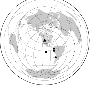
Azimuth Distribution of Events:
Prior Results for this Station
| Study | Thickness | Vp/Vs | Vp | Vs | Poissons Ratio | Extra |
| EARS | 44 km | 1.74 | 6.207 km/s | 3.577 km/s | 0.25 | |
| Crust2.0 | 37 km | 1.78 | 6.207 km/s | 3.489 km/s | 0.27 | M8,thick extended crust, 1.5 km seds. |
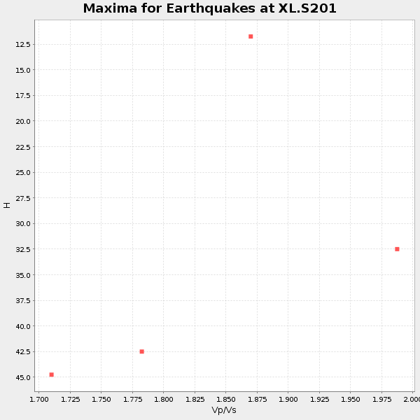
| Global Maxima | 44 km | 1.74 | 6.207 km/s | 3.577 km/s | 0.25 | amp=0.08692772 |
| Local Maxima 1 | 33 km | 1.98 | 6.207 km/s | 3.139 km/s | 0.33 | amp=0.05008887 |
| Local Maxima 2 | 41 km | 1.74 | 6.207 km/s | 3.567 km/s | 0.25 | amp=0.031988293 |
| Local Maxima 3 | 41 km | 1.91 | 6.207 km/s | 3.25 km/s | 0.31 | amp=0.019137852 |
| Local Maxima 4 | 29 km | 1.78 | 6.207 km/s | 3.492 km/s | 0.27 | amp=0.018689485 |
| Predicted Arrivals for vertical incidence (zero ray parameter) | |
| Ps | 5.24 SECOND |
| PpPs | 19.50 SECOND |
| PsPs/PpSs | 24.74 SECOND |
Events Processed for this Station
Download zip of receiver functions as SAC
Plot maxima for each earthquake.
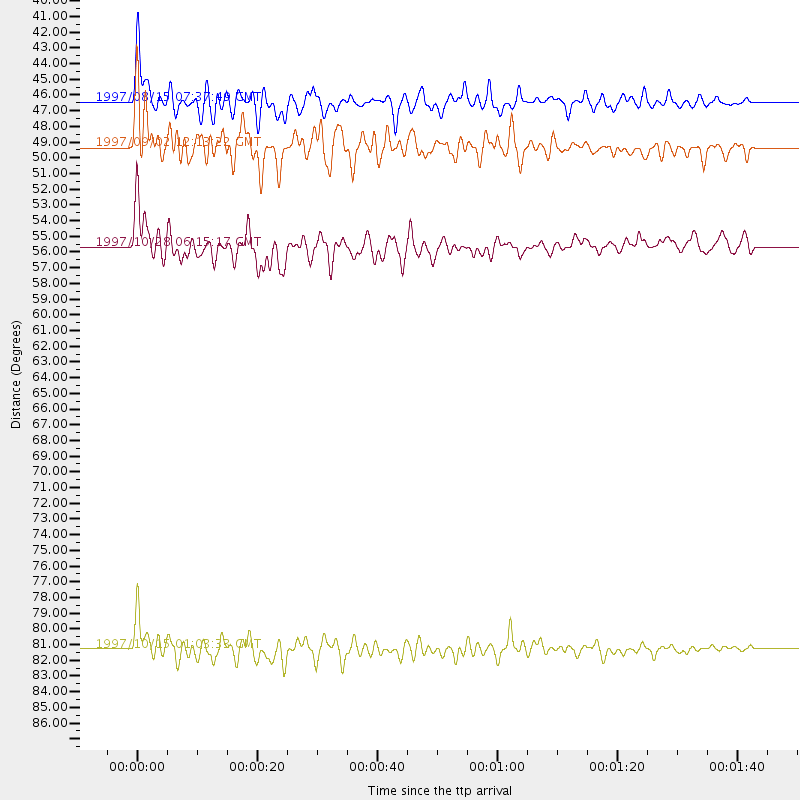
Events Used in the Stack
(4 events)| Radial Match | Distance | Baz | FERegion | Time | Lat/Lon | Depth | Magnitude |
| 93.82919 | 81.3 deg | 146.281 deg | Near Coast Of Central Chile | 1997/10/15 01:03:33 GMT | (-30.9, -71.2) | 58 km | 6.8 MB, 6.8 MS, 7.3 UNKNOWN, 7.1 MW |
| 90.7842 | 55.7 deg | 137.23 deg | Northern Peru | 1997/10/28 06:15:17 GMT | (-4.4, -76.7) | 112 km | 6.6 MB, 6.3 MS, 7.2 UNKNOWN, 6.6 ME |
| 84.75482 | 49.3 deg | 130.713 deg | Colombia | 1997/09/02 12:13:22 GMT | (3.8, -75.7) | 199 km | 6.5 MB, 6.8 UNKNOWN, 6.4 ME |
| 84.33959 | 46.4 deg | 172.824 deg | Central East Pacific Rise | 1997/08/15 07:37:49 GMT | (-4.4, -105.7) | 10 km | 5.3 MB, 5.8 MS, 6.2 UNKNOWN, 6.1 MW |
Losers
(7 events)| Radial Match | Distance | Baz | FERegion | Time | Lat/Lon | Depth | Magnitude | Reason |
| 77.62507 | 93.4 deg | 233.954 deg | Kermadec Islands Region | 1997/09/20 16:11:32 GMT | (-28.7, -177.6) | 30 km | 6.1 MB, 7.0 MS, 7.2 UNKNOWN, 6.7 ME | |
| 74.230965 | 86.1 deg | 236.731 deg | Tonga Islands | 1997/09/10 12:57:07 GMT | (-21.3, -174.4) | 10 km | 5.7 MB, 6.1 MS, 6.1 UNKNOWN, 5.9 MW | |
| 64.929665 | 75.2 deg | 139.745 deg | Northern Chile | 1997/09/28 23:13:13 GMT | (-22.4, -68.4) | 107 km | 5.7 MB, 5.6 UNKNOWN, 5.6 MW | |
| 59.94239 | 88.9 deg | 240.245 deg | Fiji Islands Region | 1997/11/04 10:40:43 GMT | (-21.0, -179.2) | 621 km | 5.7 UNKNOWN, 5.1 MB | |
| 53.375862 | 94.4 deg | 238.003 deg | South Of Fiji Islands | 1997/09/04 04:23:37 GMT | (-26.6, 178.3) | 625 km | 6.3 MB, 6.8 UNKNOWN, 6.5 ME | |
| 30.741447 | 76.4 deg | 310.831 deg | Eastern Honshu, Japan | 1997/10/26 19:06:44 GMT | (39.3, 140.5) | 134 km | 5.6 UNKNOWN, 5.2 MB | |
| 20.732885 | 88.5 deg | 240.096 deg | Fiji Islands Region | 1997/10/17 15:02:00 GMT | (-20.9, -178.8) | 579 km | 5.3 MB, 6.0 UNKNOWN, 6.0 MW |
