You are here: Home > Network List > XL97 - Deep Probe (Archean-Proterozoic) Stations List
> Station S201 Cokeville > Earthquake Result Viewer
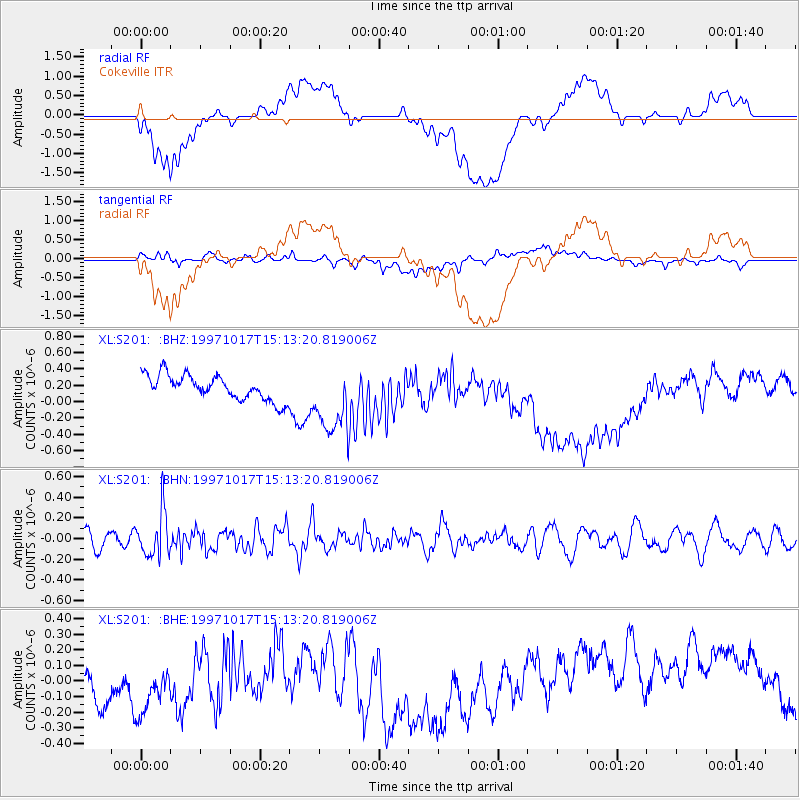
S201 Cokeville - Earthquake Result Viewer
*The percent match for this event was below the threshold and hence no stack was calculated.
| Earthquake location: |
Fiji Islands Region |
| Earthquake latitude/longitude: |
-20.9/-178.8 |
| Earthquake time(UTC): |
1997/10/17 (290) 15:02:00 GMT |
| Earthquake Depth: |
579 km |
| Earthquake Magnitude: |
5.3 MB, 6.0 UNKNOWN, 6.0 MW |
| Earthquake Catalog/Contributor: |
WHDF/NEIC |
|
| Network: |
XL Deep Probe (Archean-Proterozoic) |
| Station: |
S201 Cokeville |
| Lat/Lon: |
42.02 N/110.90 W |
| Elevation: |
1929 m |
|
| Distance: |
88.5 deg |
| Az: |
43.691 deg |
| Baz: |
240.096 deg |
| Ray Param: |
$rayparam |
*The percent match for this event was below the threshold and hence was not used in the summary stack. |
|
| Radial Match: |
20.732885 % |
| Radial Bump: |
400 |
| Transverse Match: |
46.889133 % |
| Transverse Bump: |
400 |
| SOD ConfigId: |
4480 |
| Insert Time: |
2010-03-08 18:17:14.320 +0000 |
| GWidth: |
2.5 |
| Max Bumps: |
400 |
| Tol: |
0.001 |
|
Signal To Noise
| Channel | StoN | STA | LTA |
| XL:S201: :BHN:19971017T15:13:20.819006Z | 2.171099 | 2.1108114E-7 | 9.722318E-8 |
| XL:S201: :BHE:19971017T15:13:20.819006Z | 1.2743523 | 2.4121098E-7 | 1.8928122E-7 |
| XL:S201: :BHZ:19971017T15:13:20.819006Z | 2.7883854 | 4.2625075E-7 | 1.5286652E-7 |
| Arrivals |
| Ps | |
| PpPs | |
| PsPs/PpSs | |


