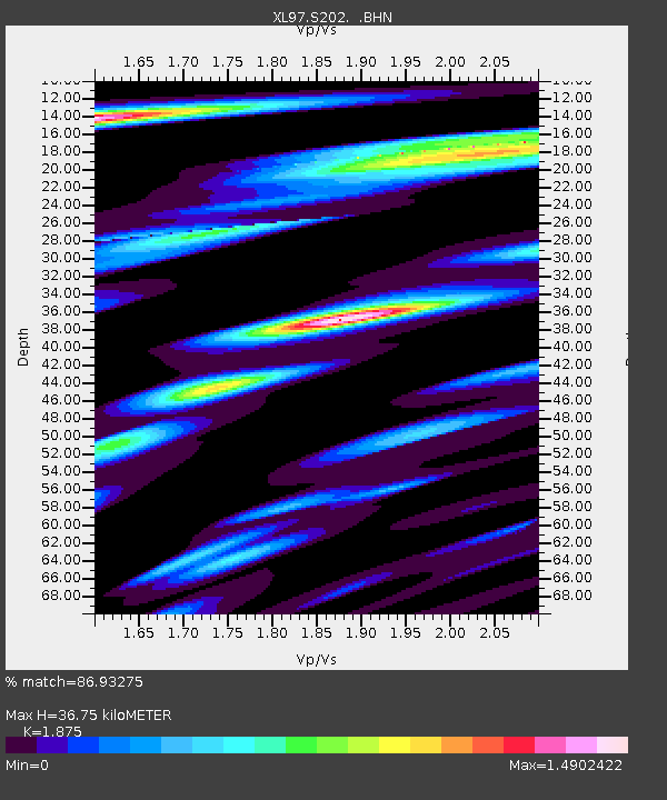
S202 Kemmerer - Earthquake Result Viewer
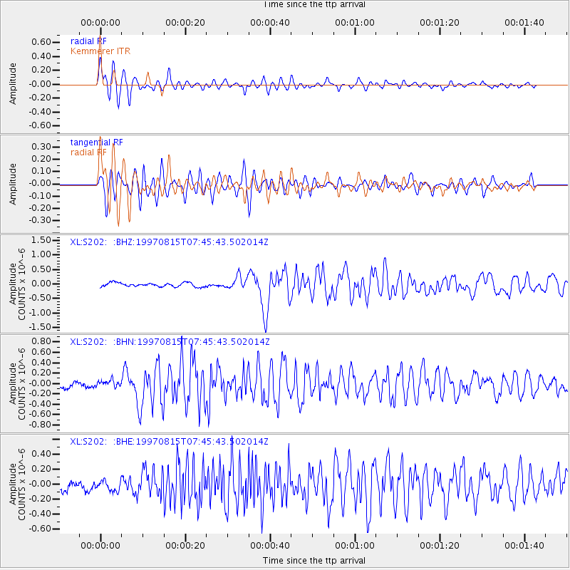
Earthquake location: Central East Pacific Rise
Earthquake latitude/longitude: -4.4/-105.7
Earthquake time(UTC): 1997/08/15 (227) 07:37:49 GMT
Earthquake Depth: 10 km
Earthquake Magnitude: 5.3 MB, 5.8 MS, 6.2 UNKNOWN, 6.1 MW
Earthquake Catalog/Contributor: WHDF/NEIC
Network: XL Deep Probe (Archean-Proterozoic)
Station: S202 Kemmerer
Lat/Lon: 41.87 N/110.84 W
Elevation: 2073 m
Distance: 46.3 deg
Az: 354.682 deg
Baz: 172.892 deg
Ray Param: 0.07075563
Estimated Moho Depth: 36.75 km
Estimated Crust Vp/Vs: 1.88
Assumed Crust Vp: 6.155 km/s
Estimated Crust Vs: 3.283 km/s
Estimated Crust Poisson's Ratio: 0.30
Radial Match: 86.93275 %
Radial Bump: 400
Transverse Match: 78.08308 %
Transverse Bump: 400
SOD ConfigId: 6273
Insert Time: 2010-03-08 18:17:16.158 +0000
GWidth: 2.5
Max Bumps: 400
Tol: 0.001

Signal To Noise

ChannelStoNSTALTA
XL:S202: :BHN:19970815T07:45:43.502014Z0.950300936.3104544E-86.640481E-8
XL:S202: :BHE:19970815T07:45:43.502014Z1.34602376.919477E-85.1406797E-8
XL:S202: :BHZ:19970815T07:45:43.502014Z3.2286162.1655366E-76.7073216E-8
Arrivals
Ps5.5 SECOND
PpPs16 SECOND
PsPs/PpSs22 SECOND