
Station XL S202 - Kemmerer
Network: XL97 - Deep Probe (Archean-Proterozoic)
Nearby stations (2 deg radius)
| Station | Name | (Lat, Lon) | Start / End | Elevation |
| S202 | Kemmerer | (41.87, -110.84) | 1997-08-13 / 1997-12-31 | 2073 m |
| Crust2 Type: | M2,extended crust, 2 km seds. |
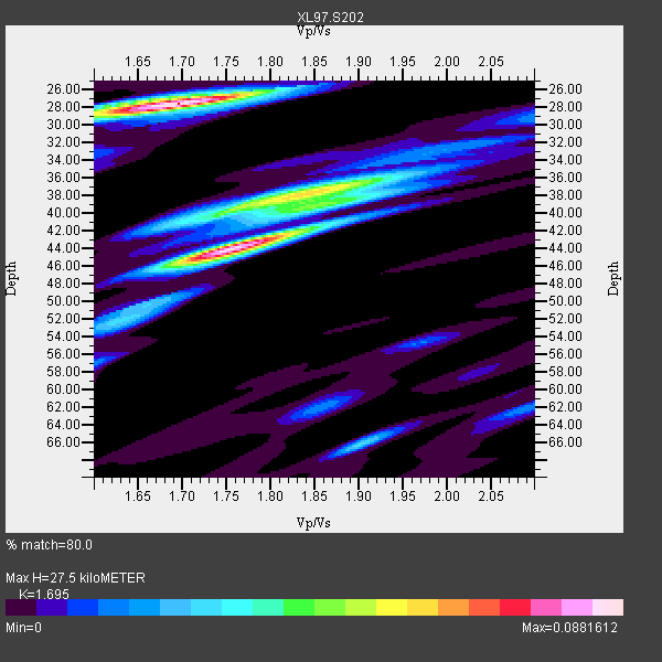
| Thickness Estimate: | 28 km |
| Thickness StdDev: | 5.9 km |
| Vp/Vs Estimate: | 1.70 |
| Vp/Vs StdDev: | 0.08 |
| Vs Estimate: | 3.631 km/s |
| Poisson's Ratio: | 0.23 |
| Peak Value: | 0.09 |
| Assumed Vp: | 6.155 km/s |
| Ps Weight: | 0.33333334 |
| PpPs Weight: | 0.33333334 |
| PsPs Weight: | 0.33333328 |
| Residual Complexity: | 0.812 |
| Nearby stations H: | +- |
| (2.0 deg) Vp/Vs: | +- |
0 with match > 90% ( 0.0 %) and 3 with match > 80% ( 21.428572 %) out of 14.
Download stack as xyz text file.
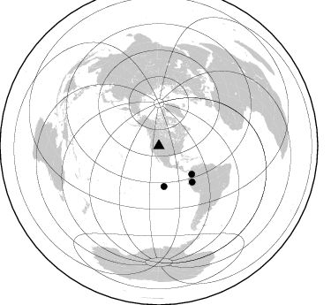
Azimuth Distribution of Events:
Prior Results for this Station
| Study | Thickness | Vp/Vs | Vp | Vs | Poissons Ratio | Extra |
| EARS | 28 km | 1.70 | 6.155 km/s | 3.631 km/s | 0.23 | |
| Crust2.0 | 31 km | 1.78 | 6.155 km/s | 3.458 km/s | 0.27 | M2,extended crust, 2 km seds. |
| Global Maxima | 28 km | 1.70 | 6.155 km/s | 3.631 km/s | 0.23 | amp=0.0881612 |
| Local Maxima 1 | 44 km | 1.75 | 6.155 km/s | 3.507 km/s | 0.26 | amp=0.08586178 |
| Local Maxima 2 | 38 km | 1.82 | 6.155 km/s | 3.377 km/s | 0.28 | amp=0.047742296 |
| Local Maxima 3 | 66 km | 1.90 | 6.155 km/s | 3.235 km/s | 0.31 | amp=0.028468214 |
| Local Maxima 4 | 39 km | 1.88 | 6.155 km/s | 3.283 km/s | 0.30 | amp=0.02818408 |
| Predicted Arrivals for vertical incidence (zero ray parameter) | |
| Ps | 3.11 SECOND |
| PpPs | 12.04 SECOND |
| PsPs/PpSs | 15.15 SECOND |
Events Processed for this Station
Download zip of receiver functions as SAC
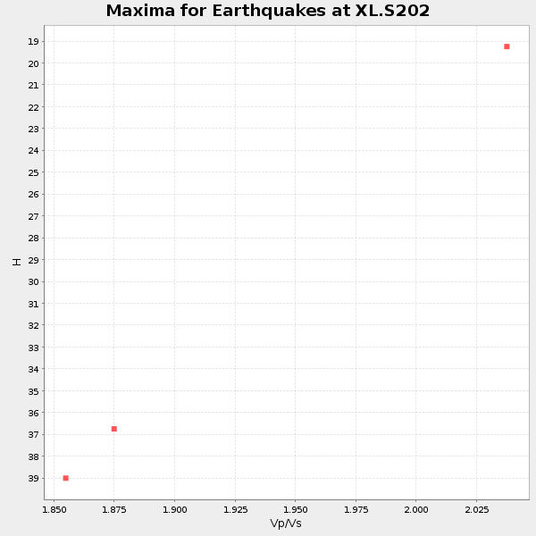
Plot maxima for each earthquake.
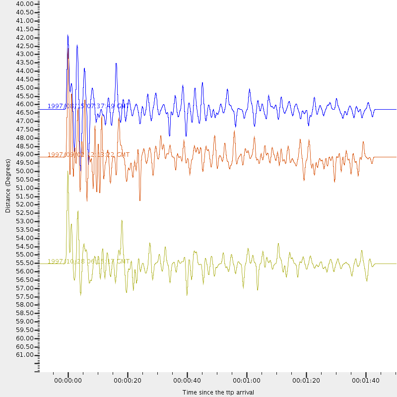
Events Used in the Stack
(3 events)| Radial Match | Distance | Baz | FERegion | Time | Lat/Lon | Depth | Magnitude |
| 88.70995 | 55.5 deg | 137.223 deg | Northern Peru | 1997/10/28 06:15:17 GMT | (-4.4, -76.7) | 112 km | 6.6 MB, 6.3 MS, 7.2 UNKNOWN, 6.6 ME |
| 86.93275 | 46.3 deg | 172.892 deg | Central East Pacific Rise | 1997/08/15 07:37:49 GMT | (-4.4, -105.7) | 10 km | 5.3 MB, 5.8 MS, 6.2 UNKNOWN, 6.1 MW |
| 80.20659 | 49.1 deg | 130.679 deg | Colombia | 1997/09/02 12:13:22 GMT | (3.8, -75.7) | 199 km | 6.5 MB, 6.8 UNKNOWN, 6.4 ME |
Losers
(11 events)| Radial Match | Distance | Baz | FERegion | Time | Lat/Lon | Depth | Magnitude | Reason |
| 79.44153 | 93.4 deg | 233.987 deg | Kermadec Islands Region | 1997/09/20 16:11:32 GMT | (-28.7, -177.6) | 30 km | 6.1 MB, 7.0 MS, 7.2 UNKNOWN, 6.7 ME | |
| 79.16805 | 81.1 deg | 146.315 deg | Near Coast Of Central Chile | 1997/10/15 01:03:33 GMT | (-30.9, -71.2) | 58 km | 6.8 MB, 6.8 MS, 7.3 UNKNOWN, 7.1 MW | |
| 73.42715 | 86.0 deg | 236.784 deg | Tonga Islands | 1997/09/10 12:57:07 GMT | (-21.3, -174.4) | 10 km | 5.7 MB, 6.1 MS, 6.1 UNKNOWN, 5.9 MW | |
| 69.857925 | 94.4 deg | 238.032 deg | South Of Fiji Islands | 1997/09/04 04:23:37 GMT | (-26.6, 178.3) | 625 km | 6.3 MB, 6.8 UNKNOWN, 6.5 ME | |
| 58.242245 | 75.0 deg | 139.77 deg | Northern Chile | 1997/09/28 23:13:13 GMT | (-22.4, -68.4) | 107 km | 5.7 MB, 5.6 UNKNOWN, 5.6 MW | |
| 49.25947 | 92.9 deg | 254.493 deg | Vanuatu Islands | 1997/08/17 20:11:10 GMT | (-13.6, 167.4) | 26 km | 5.4 MB, 6.1 MS, 6.1 UNKNOWN, 6.0 MW | |
| 48.33995 | 76.5 deg | 310.893 deg | Eastern Honshu, Japan | 1997/10/26 19:06:44 GMT | (39.3, 140.5) | 134 km | 5.6 UNKNOWN, 5.2 MB | |
| 41.0992 | 88.8 deg | 240.29 deg | Fiji Islands Region | 1997/11/04 10:40:43 GMT | (-21.0, -179.2) | 621 km | 5.7 UNKNOWN, 5.1 MB | |
| 39.983284 | 80.9 deg | 146.325 deg | Near Coast Of Central Chile | 1997/11/03 20:12:52 GMT | (-30.8, -71.3) | 45 km | 5.6 MB, 5.2 MD | |
| 32.822784 | 97.5 deg | 192.921 deg | Pacific-Antarctic Ridge | 1997/10/26 13:55:33 GMT | (-54.1, -133.0) | 10 km | 5.5 MS, 5.1 MB | |
| 29.024132 | 88.5 deg | 240.142 deg | Fiji Islands Region | 1997/10/17 15:02:00 GMT | (-20.9, -178.8) | 579 km | 5.3 MB, 6.0 UNKNOWN, 6.0 MW |
