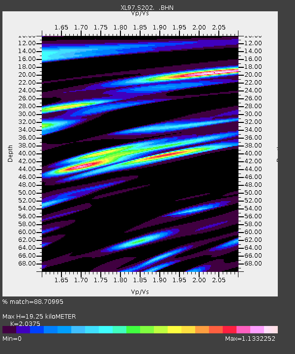
S202 Kemmerer - Earthquake Result Viewer
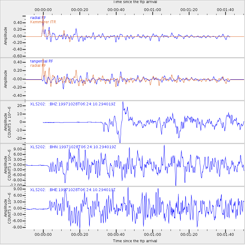
Earthquake location: Northern Peru
Earthquake latitude/longitude: -4.4/-76.7
Earthquake time(UTC): 1997/10/28 (301) 06:15:17 GMT
Earthquake Depth: 112 km
Earthquake Magnitude: 6.6 MB, 6.3 MS, 7.2 UNKNOWN, 6.6 ME
Earthquake Catalog/Contributor: WHDF/NEIC
Network: XL Deep Probe (Archean-Proterozoic)
Station: S202 Kemmerer
Lat/Lon: 41.87 N/110.84 W
Elevation: 2073 m
Distance: 55.5 deg
Az: 329.421 deg
Baz: 137.223 deg
Ray Param: 0.06438782
Estimated Moho Depth: 19.25 km
Estimated Crust Vp/Vs: 2.04
Assumed Crust Vp: 6.155 km/s
Estimated Crust Vs: 3.021 km/s
Estimated Crust Poisson's Ratio: 0.34
Radial Match: 88.70995 %
Radial Bump: 400
Transverse Match: 79.355225 %
Transverse Bump: 400
SOD ConfigId: 6273
Insert Time: 2010-03-08 18:17:18.212 +0000
GWidth: 2.5
Max Bumps: 400
Tol: 0.001

Signal To Noise

ChannelStoNSTALTA
XL:S202: :BHN:19971028T06:24:10.294019Z6.0670251.6000854E-62.6373476E-7
XL:S202: :BHE:19971028T06:24:10.294019Z11.1517691.2961202E-61.1622553E-7
XL:S202: :BHZ:19971028T06:24:10.294019Z20.691433.2042349E-61.5485807E-7
Arrivals
Ps3.4 SECOND
PpPs9.1 SECOND
PsPs/PpSs13 SECOND