You are here: Home > Network List > IC - New China Digital Seismograph Network Stations List
> Station HIA Hailar, Neimenggu Autonomous Region, China > Earthquake Result Viewer
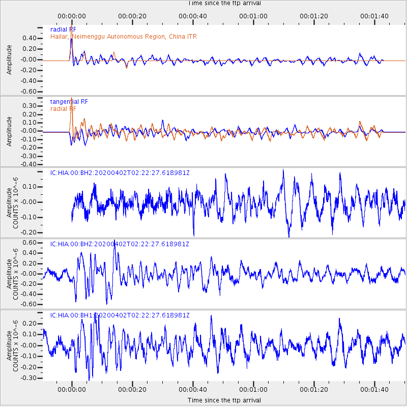
HIA Hailar, Neimenggu Autonomous Region, China - Earthquake Result Viewer
*The percent match for this event was below the threshold and hence no stack was calculated.
| Earthquake location: |
Banda Sea |
| Earthquake latitude/longitude: |
-8.0/125.7 |
| Earthquake time(UTC): |
2020/04/02 (093) 02:13:14 GMT |
| Earthquake Depth: |
35 km |
| Earthquake Magnitude: |
5.5 Mww |
| Earthquake Catalog/Contributor: |
NEIC PDE/us |
|
| Network: |
IC New China Digital Seismograph Network |
| Station: |
HIA Hailar, Neimenggu Autonomous Region, China |
| Lat/Lon: |
49.27 N/119.74 E |
| Elevation: |
620 m |
|
| Distance: |
57.2 deg |
| Az: |
355.389 deg |
| Baz: |
173.018 deg |
| Ray Param: |
$rayparam |
*The percent match for this event was below the threshold and hence was not used in the summary stack. |
|
| Radial Match: |
65.665886 % |
| Radial Bump: |
400 |
| Transverse Match: |
55.47227 % |
| Transverse Bump: |
400 |
| SOD ConfigId: |
21144311 |
| Insert Time: |
2020-04-16 02:16:10.204 +0000 |
| GWidth: |
2.5 |
| Max Bumps: |
400 |
| Tol: |
0.001 |
|
Signal To Noise
| Channel | StoN | STA | LTA |
| IC:HIA:00:BHZ:20200402T02:22:27.618981Z | 6.085134 | 2.6567264E-7 | 4.365929E-8 |
| IC:HIA:00:BH1:20200402T02:22:27.618981Z | 2.3249304 | 1.2560515E-7 | 5.402534E-8 |
| IC:HIA:00:BH2:20200402T02:22:27.618981Z | 1.0201343 | 4.8249753E-8 | 4.729745E-8 |
| Arrivals |
| Ps | |
| PpPs | |
| PsPs/PpSs | |


