You are here: Home > Network List > SP - South Carolina Earth Physics Project Stations List
> Station ACFLR A.C. Flora High School, Richland County, SC USA > Earthquake Result Viewer
ACFLR A.C. Flora High School, Richland County, SC USA - Earthquake Result Viewer
| Earthquake location: |
Northwest Of Kuril Islands |
| Earthquake latitude/longitude: |
47.8/146.2 |
| Earthquake time(UTC): |
2002/11/17 (321) 04:53:53 GMT |
| Earthquake Depth: |
459 km |
| Earthquake Magnitude: |
7.3 MW, 7.3 MW |
| Earthquake Catalog/Contributor: |
WHDF/NEIC |
|
| Network: |
SP South Carolina Earth Physics Project |
| Station: |
ACFLR A.C. Flora High School, Richland County, SC USA |
| Lat/Lon: |
34.02 N/80.98 W |
| Elevation: |
91 m |
|
| Distance: |
88.2 deg |
| Az: |
37.565 deg |
| Baz: |
330.355 deg |
| Ray Param: |
0.041713893 |
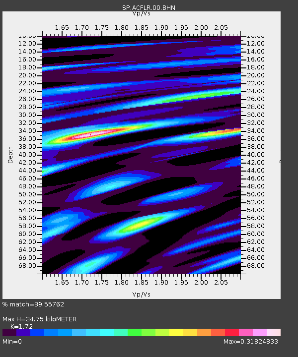
| Estimated Moho Depth: |
34.75 km |
| Estimated Crust Vp/Vs: |
1.72 |
| Assumed Crust Vp: |
6.419 km/s |
| Estimated Crust Vs: |
3.732 km/s |
| Estimated Crust Poisson's Ratio: |
0.24 |
|
| Radial Match: |
89.55762 % |
| Radial Bump: |
400 |
| Transverse Match: |
63.14382 % |
| Transverse Bump: |
400 |
| SOD ConfigId: |
2132 |
| Insert Time: |
2010-02-25 16:29:16.887 +0000 |
| GWidth: |
2.5 |
| Max Bumps: |
400 |
| Tol: |
0.001 |
|
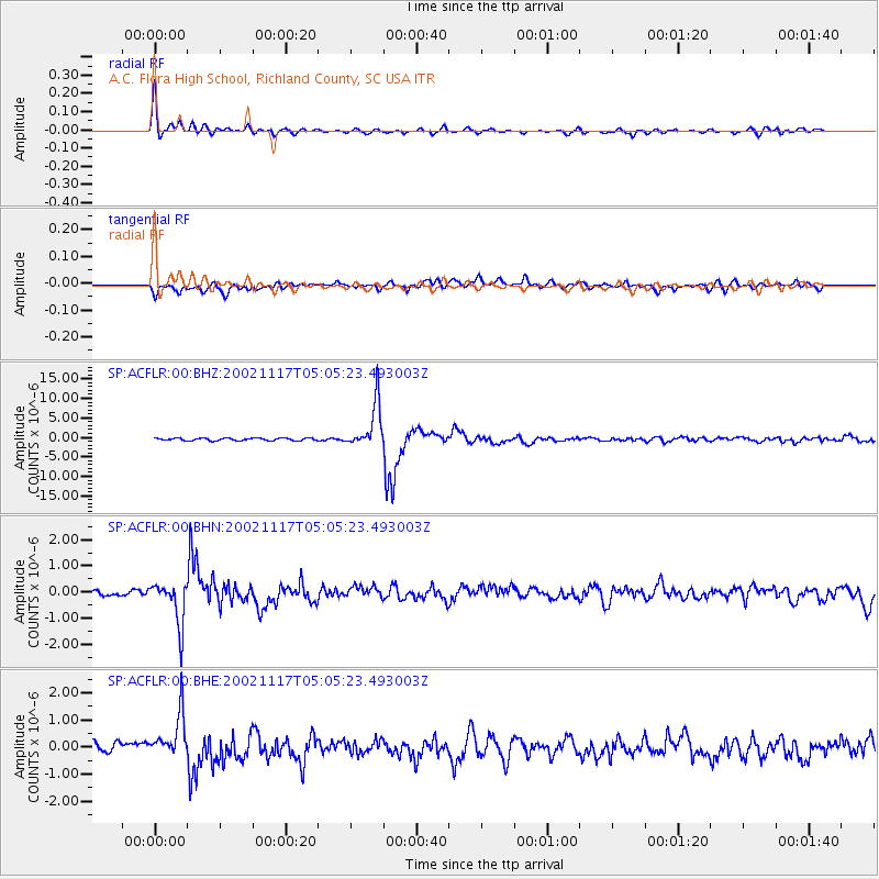
Signal To Noise
| Channel | StoN | STA | LTA |
| SP:ACFLR:00:BHN:20021117T05:05:23.493003Z | 8.567694 | 8.277994E-7 | 9.66187E-8 |
| SP:ACFLR:00:BHE:20021117T05:05:23.493003Z | 4.33297 | 8.452269E-7 | 1.9506872E-7 |
| SP:ACFLR:00:BHZ:20021117T05:05:23.493003Z | 17.260025 | 5.715158E-6 | 3.3112104E-7 |
| Arrivals |
| Ps | 4.0 SECOND |
| PpPs | 14 SECOND |
| PsPs/PpSs | 18 SECOND |


