
Station SP ACFLR - A.C. Flora High School, Richland County, SC USA
Network: SP - South Carolina Earth Physics Project
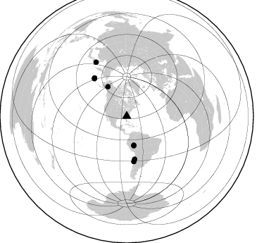
Nearby stations (2 deg radius)
| Station | Name | (Lat, Lon) | Start / End | Elevation |
| ACFLR | A.C. Flora High School, Richland County, SC USA | (34.02, -80.98) | 2001-09-17 / 2004-01-24 | 91 m |
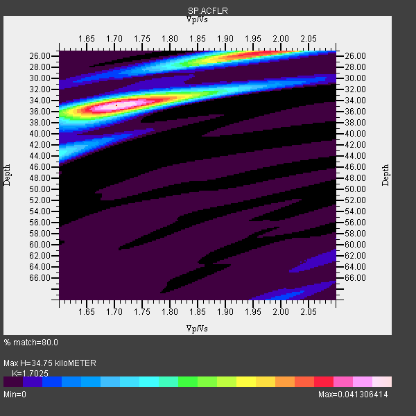
| Crust2 Type: | Q2,orogen/39km no ice, Appalachians, North Andes, 0.5 km seds. |
| Thickness Estimate: | 35 km |
| Thickness StdDev: | 2.3 km |
| Vp/Vs Estimate: | 1.70 |
| Vp/Vs StdDev: | 0.07 |
| Vs Estimate: | 3.77 km/s |
| Poisson's Ratio: | 0.24 |
| Peak Value: | 0.04 |
| Assumed Vp: | 6.419 km/s |
| Ps Weight: | 0.33333334 |
| PpPs Weight: | 0.33333334 |
| PsPs Weight: | 0.33333328 |
| Residual Complexity: | 0.571 |
| Nearby stations H: | +- |
| (2.0 deg) Vp/Vs: | +- |
4 with match > 90% ( 44.444443 %) and 8 with match > 80% ( 88.888885 %) out of 9.
Download stack as xyz text file.
Azimuth Distribution of Events:
Prior Results for this Station
| Study | Thickness | Vp/Vs | Vp | Vs | Poissons Ratio | Extra |
| EARS | 35 km | 1.70 | 6.419 km/s | 3.77 km/s | 0.24 | |
| Crust2.0 | 39 km | 1.75 | 6.419 km/s | 3.659 km/s | 0.26 | Q2,orogen/39km no ice, Appalachians, North Andes, 0.5 km seds. |
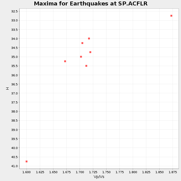
| Global Maxima | 35 km | 1.70 | 6.419 km/s | 3.77 km/s | 0.24 | amp=0.041306414 |
| Local Maxima 1 | 25 km | 1.96 | 6.419 km/s | 3.275 km/s | 0.32 | amp=0.033791915 |
| Local Maxima 2 | 36 km | 1.71 | 6.419 km/s | 3.754 km/s | 0.24 | amp=0.015504318 |
| Local Maxima 3 | 44 km | 1.61 | 6.419 km/s | 4.0 km/s | 0.18 | amp=0.01228587 |
| Local Maxima 4 | 34 km | 1.69 | 6.419 km/s | 3.798 km/s | 0.23 | amp=0.010238565 |
| Predicted Arrivals for vertical incidence (zero ray parameter) | |
| Ps | 3.80 SECOND |
| PpPs | 14.63 SECOND |
| PsPs/PpSs | 18.43 SECOND |
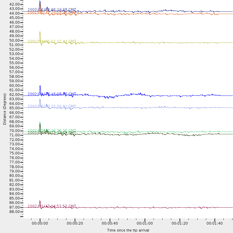
Events Processed for this Station
Download zip of receiver functions as SAC
Plot maxima for each earthquake.
Events Used in the Stack
(8 events)| Radial Match | Distance | Baz | FERegion | Time | Lat/Lon | Depth | Magnitude |
| 97.84437 | 49.7 deg | 327.402 deg | Central Alaska | 2002/11/03 22:12:41 GMT | (63.5, -147.4) | 4.9 km | 7.0 MB, 8.5 MS, 7.9 MW |
| 93.53398 | 42.3 deg | 166.292 deg | Western Brazil | 2003/06/20 06:19:38 GMT | (-7.6, -71.7) | 558 km | 6.4 MB, 7.1 MW, 7.0 MW |
| 92.282974 | 43.0 deg | 166.514 deg | Western Brazil | 2002/10/12 20:09:11 GMT | (-8.3, -71.7) | 534 km | 6.5 MB, 6.9 MW, 6.9 MW |
| 90.54543 | 64.9 deg | 171.104 deg | Near Coast Of Central Chile | 2003/06/20 13:30:41 GMT | (-30.6, -71.6) | 33 km | 6.4 MB, 6.8 MS, 6.8 MW, 6.7 MW |
| 89.55762 | 88.2 deg | 330.355 deg | Northwest Of Kuril Islands | 2002/11/17 04:53:53 GMT | (47.8, 146.2) | 459 km | 7.3 MW, 7.3 MW |
| 87.29319 | 71.1 deg | 319.714 deg | Rat Islands, Aleutian Islands | 2003/06/23 12:12:34 GMT | (51.4, 176.8) | 20 km | 6.3 MB, 7.0 MS, 6.9 MW, 6.8 MW |
| 83.67193 | 62.0 deg | 169.543 deg | Near Coast Of Northern Chile | 2002/04/18 16:08:36 GMT | (-27.5, -70.6) | 62 km | 6.2 MB, 6.7 MW, 6.6 MW |
| 83.17338 | 70.5 deg | 319.159 deg | Rat Islands, Aleutian Islands | 2003/03/17 16:36:17 GMT | (51.3, 178.0) | 33 km | 5.9 MB, 6.7 MS, 7.0 MW, 7.0 MW |
Losers
(1 events)| Radial Match | Distance | Baz | FERegion | Time | Lat/Lon | Depth | Magnitude | Reason |
| 80.35631 | 83.7 deg | 326.515 deg | Kuril Islands | 2003/04/24 10:56:21 GMT | (48.8, 155.0) | 44 km | 5.6 MB, 5.7 MS, 6.1 MW, 6.0 MW |
