You are here: Home > Network List > SP - South Carolina Earth Physics Project Stations List
> Station AGBLF Silver Bluff High School, Aiken County, SC, USA > Earthquake Result Viewer
AGBLF Silver Bluff High School, Aiken County, SC, USA - Earthquake Result Viewer
| Earthquake location: |
Chile-Bolivia Border Region |
| Earthquake latitude/longitude: |
-21.7/-68.3 |
| Earthquake time(UTC): |
2002/03/28 (087) 04:56:22 GMT |
| Earthquake Depth: |
125 km |
| Earthquake Magnitude: |
6.1 MB, 6.5 MW, 6.5 MW |
| Earthquake Catalog/Contributor: |
WHDF/NEIC |
|
| Network: |
SP South Carolina Earth Physics Project |
| Station: |
AGBLF Silver Bluff High School, Aiken County, SC, USA |
| Lat/Lon: |
33.40 N/81.76 W |
| Elevation: |
118 m |
|
| Distance: |
56.2 deg |
| Az: |
346.483 deg |
| Baz: |
164.937 deg |
| Ray Param: |
0.0638866 |
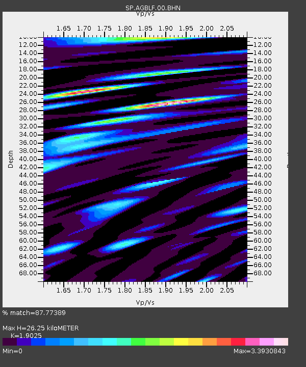
| Estimated Moho Depth: |
26.25 km |
| Estimated Crust Vp/Vs: |
1.90 |
| Assumed Crust Vp: |
6.565 km/s |
| Estimated Crust Vs: |
3.45 km/s |
| Estimated Crust Poisson's Ratio: |
0.31 |
|
| Radial Match: |
87.77389 % |
| Radial Bump: |
400 |
| Transverse Match: |
75.48332 % |
| Transverse Bump: |
400 |
| SOD ConfigId: |
2149 |
| Insert Time: |
2010-02-25 16:29:29.764 +0000 |
| GWidth: |
2.5 |
| Max Bumps: |
400 |
| Tol: |
0.001 |
|
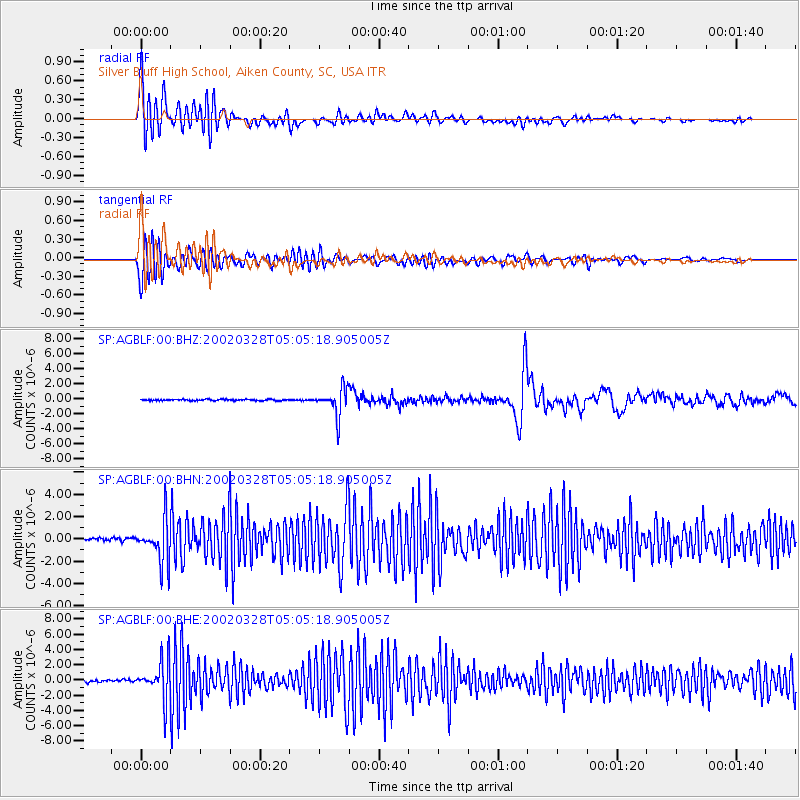
Signal To Noise
| Channel | StoN | STA | LTA |
| SP:AGBLF:00:BHN:20020328T05:05:18.905005Z | 17.387085 | 1.9007953E-6 | 1.09322244E-7 |
| SP:AGBLF:00:BHE:20020328T05:05:18.905005Z | 14.3272 | 2.4925125E-6 | 1.7397068E-7 |
| SP:AGBLF:00:BHZ:20020328T05:05:18.905005Z | 19.843948 | 1.8030302E-6 | 9.086045E-8 |
| Arrivals |
| Ps | 3.8 SECOND |
| PpPs | 11 SECOND |
| PsPs/PpSs | 15 SECOND |


