
Station SP AGBLF - Silver Bluff High School, Aiken County, SC, USA
Network: SP - South Carolina Earth Physics Project
Nearby stations (2 deg radius)
| Station | Name | (Lat, Lon) | Start / End | Elevation |
| AGBLF | Silver Bluff High School, Aiken County, SC, USA | (33.40, -81.76) | 2001-09-11 / 2499-01-01 | 118 m |
| Crust2 Type: | DG,thin Platform 1 km seds. |
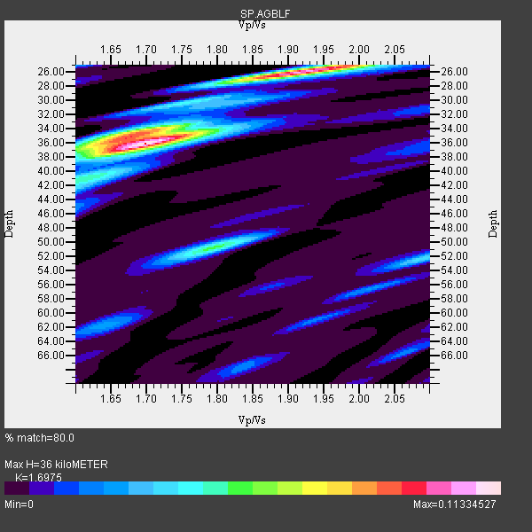
| Thickness Estimate: | 36 km |
| Thickness StdDev: | 5.0 km |
| Vp/Vs Estimate: | 1.70 |
| Vp/Vs StdDev: | 0.12 |
| Vs Estimate: | 3.867 km/s |
| Poisson's Ratio: | 0.23 |
| Peak Value: | 0.11 |
| Assumed Vp: | 6.565 km/s |
| Ps Weight: | 0.33333334 |
| PpPs Weight: | 0.33333334 |
| PsPs Weight: | 0.33333328 |
| Residual Complexity: | 0.654 |
| Nearby stations H: | +- |
| (2.0 deg) Vp/Vs: | +- |
2 with match > 90% ( 20.0 %) and 9 with match > 80% ( 90.0 %) out of 10.
Download stack as xyz text file.
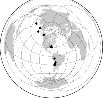
Azimuth Distribution of Events:
Prior Results for this Station
| Study | Thickness | Vp/Vs | Vp | Vs | Poissons Ratio | Extra |
| EARS | 36 km | 1.70 | 6.565 km/s | 3.867 km/s | 0.23 | |
| Crust2.0 | 31 km | 1.78 | 6.565 km/s | 3.684 km/s | 0.27 | DG,thin Platform 1 km seds. |
| Global Maxima | 36 km | 1.70 | 6.565 km/s | 3.867 km/s | 0.23 | amp=0.11334527 |
| Local Maxima 1 | 26 km | 1.93 | 6.565 km/s | 3.406 km/s | 0.32 | amp=0.10333077 |
| Local Maxima 2 | 35 km | 1.68 | 6.565 km/s | 3.907 km/s | 0.23 | amp=0.06429768 |
| Local Maxima 3 | 51 km | 1.79 | 6.565 km/s | 3.667 km/s | 0.27 | amp=0.052724123 |
| Local Maxima 4 | 52 km | 2.10 | 6.565 km/s | 3.13 km/s | 0.35 | amp=0.036677558 |
| Predicted Arrivals for vertical incidence (zero ray parameter) | |
| Ps | 3.83 SECOND |
| PpPs | 14.79 SECOND |
| PsPs/PpSs | 18.62 SECOND |
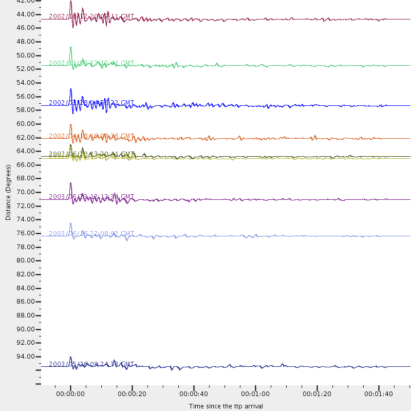
Events Processed for this Station
Download zip of receiver functions as SAC
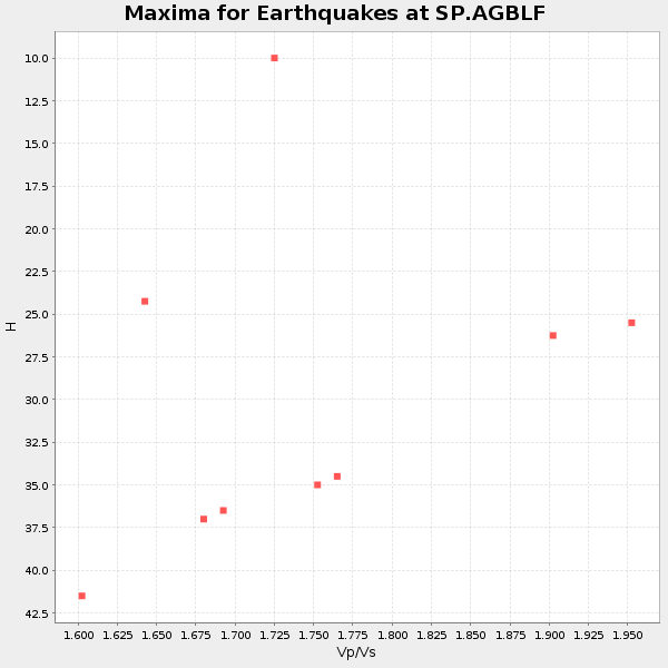
Plot maxima for each earthquake.
Events Used in the Stack
(9 events)| Radial Match | Distance | Baz | FERegion | Time | Lat/Lon | Depth | Magnitude |
| 91.91074 | 49.9 deg | 327.715 deg | Central Alaska | 2002/11/03 22:12:41 GMT | (63.5, -147.4) | 4.9 km | 7.0 MB, 8.5 MS, 7.9 MW |
| 91.70129 | 64.4 deg | 170.326 deg | Near Coast Of Central Chile | 2003/06/20 13:30:41 GMT | (-30.6, -71.6) | 33 km | 6.4 MB, 6.8 MS, 6.8 MW, 6.7 MW |
| 89.458176 | 71.1 deg | 319.592 deg | Rat Islands, Aleutian Islands | 2003/06/23 12:12:34 GMT | (51.4, 176.8) | 20 km | 6.3 MB, 7.0 MS, 6.9 MW, 6.8 MW |
| 88.635956 | 42.5 deg | 165.245 deg | Western Brazil | 2002/10/12 20:09:11 GMT | (-8.3, -71.7) | 534 km | 6.5 MB, 6.9 MW, 6.9 MW |
| 88.13907 | 64.6 deg | 169.88 deg | Near Coast Of Central Chile | 2002/06/18 13:56:22 GMT | (-30.8, -71.1) | 54 km | 6.0 MB, 6.6 MW, 6.4 MW |
| 87.77389 | 56.2 deg | 164.937 deg | Chile-Bolivia Border Region | 2002/03/28 04:56:22 GMT | (-21.7, -68.3) | 125 km | 6.1 MB, 6.5 MW, 6.5 MW |
| 87.7712 | 77.0 deg | 329.032 deg | Kamchatka Peninsula, Russia | 2003/06/16 22:08:02 GMT | (55.5, 160.0) | 175 km | 6.3 MB, 6.9 MW, 6.9 MW |
| 83.210625 | 61.5 deg | 168.712 deg | Near Coast Of Northern Chile | 2002/04/18 16:08:36 GMT | (-27.5, -70.6) | 62 km | 6.2 MB, 6.7 MW, 6.6 MW |
| 81.98034 | 97.6 deg | 327.277 deg | Near East Coast Of Honshu, Japan | 2003/05/26 09:24:33 GMT | (38.8, 141.6) | 68 km | 6.7 MB, 7.0 MW, 7.0 MW |
Losers
(1 events)| Radial Match | Distance | Baz | FERegion | Time | Lat/Lon | Depth | Magnitude | Reason |
| 86.024155 | 41.9 deg | 165.001 deg | Western Brazil | 2003/06/20 06:19:38 GMT | (-7.6, -71.7) | 558 km | 6.4 MB, 7.1 MW, 7.0 MW |
