You are here: Home > Network List > SP - South Carolina Earth Physics Project Stations List
> Station AGBLF Silver Bluff High School, Aiken County, SC, USA > Earthquake Result Viewer
AGBLF Silver Bluff High School, Aiken County, SC, USA - Earthquake Result Viewer
| Earthquake location: |
Near Coast Of Northern Chile |
| Earthquake latitude/longitude: |
-27.5/-70.6 |
| Earthquake time(UTC): |
2002/04/18 (108) 16:08:36 GMT |
| Earthquake Depth: |
62 km |
| Earthquake Magnitude: |
6.2 MB, 6.7 MW, 6.6 MW |
| Earthquake Catalog/Contributor: |
WHDF/NEIC |
|
| Network: |
SP South Carolina Earth Physics Project |
| Station: |
AGBLF Silver Bluff High School, Aiken County, SC, USA |
| Lat/Lon: |
33.40 N/81.76 W |
| Elevation: |
118 m |
|
| Distance: |
61.5 deg |
| Az: |
349.373 deg |
| Baz: |
168.712 deg |
| Ray Param: |
0.06067654 |
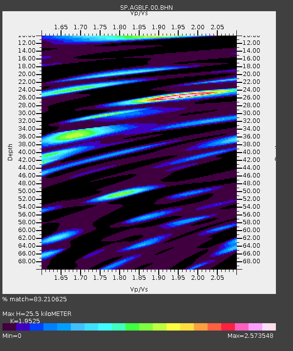
| Estimated Moho Depth: |
25.5 km |
| Estimated Crust Vp/Vs: |
1.95 |
| Assumed Crust Vp: |
6.565 km/s |
| Estimated Crust Vs: |
3.362 km/s |
| Estimated Crust Poisson's Ratio: |
0.32 |
|
| Radial Match: |
83.210625 % |
| Radial Bump: |
400 |
| Transverse Match: |
76.34457 % |
| Transverse Bump: |
400 |
| SOD ConfigId: |
2149 |
| Insert Time: |
2010-02-25 16:29:32.005 +0000 |
| GWidth: |
2.5 |
| Max Bumps: |
400 |
| Tol: |
0.001 |
|

Signal To Noise
| Channel | StoN | STA | LTA |
| SP:AGBLF:00:BHN:20020418T16:18:16.537019Z | 3.5357313 | 8.747289E-7 | 2.4739688E-7 |
| SP:AGBLF:00:BHE:20020418T16:18:16.537019Z | 4.1390276 | 1.0124464E-6 | 2.446097E-7 |
| SP:AGBLF:00:BHZ:20020418T16:18:16.537019Z | 3.3178623 | 1.0720289E-6 | 3.2310834E-7 |
| Arrivals |
| Ps | 3.9 SECOND |
| PpPs | 11 SECOND |
| PsPs/PpSs | 15 SECOND |


