You are here: Home > Network List > SP - South Carolina Earth Physics Project Stations List
> Station AGBLF Silver Bluff High School, Aiken County, SC, USA > Earthquake Result Viewer
AGBLF Silver Bluff High School, Aiken County, SC, USA - Earthquake Result Viewer
| Earthquake location: |
Near Coast Of Central Chile |
| Earthquake latitude/longitude: |
-30.8/-71.1 |
| Earthquake time(UTC): |
2002/06/18 (169) 13:56:22 GMT |
| Earthquake Depth: |
54 km |
| Earthquake Magnitude: |
6.0 MB, 6.6 MW, 6.4 MW |
| Earthquake Catalog/Contributor: |
WHDF/NEIC |
|
| Network: |
SP South Carolina Earth Physics Project |
| Station: |
AGBLF Silver Bluff High School, Aiken County, SC, USA |
| Lat/Lon: |
33.40 N/81.76 W |
| Elevation: |
118 m |
|
| Distance: |
64.6 deg |
| Az: |
350.163 deg |
| Baz: |
169.88 deg |
| Ray Param: |
0.058675762 |
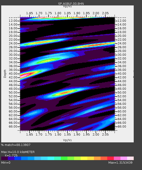
| Estimated Moho Depth: |
10.0 km |
| Estimated Crust Vp/Vs: |
1.73 |
| Assumed Crust Vp: |
6.565 km/s |
| Estimated Crust Vs: |
3.806 km/s |
| Estimated Crust Poisson's Ratio: |
0.25 |
|
| Radial Match: |
88.13907 % |
| Radial Bump: |
400 |
| Transverse Match: |
82.87738 % |
| Transverse Bump: |
400 |
| SOD ConfigId: |
2149 |
| Insert Time: |
2010-02-25 16:29:33.951 +0000 |
| GWidth: |
2.5 |
| Max Bumps: |
400 |
| Tol: |
0.001 |
|

Signal To Noise
| Channel | StoN | STA | LTA |
| SP:AGBLF:00:BHN:20020618T14:06:24.119001Z | 4.679452 | 7.1267954E-7 | 1.5229979E-7 |
| SP:AGBLF:00:BHE:20020618T14:06:24.119001Z | 3.3956153 | 6.230404E-7 | 1.834838E-7 |
| SP:AGBLF:00:BHZ:20020618T14:06:24.119001Z | 11.98239 | 1.4439348E-6 | 1.2050474E-7 |
| Arrivals |
| Ps | 1.2 SECOND |
| PpPs | 4.0 SECOND |
| PsPs/PpSs | 5.1 SECOND |


