You are here: Home > Network List > SP - South Carolina Earth Physics Project Stations List
> Station AGBLF Silver Bluff High School, Aiken County, SC, USA > Earthquake Result Viewer
AGBLF Silver Bluff High School, Aiken County, SC, USA - Earthquake Result Viewer

| Earthquake location: |
Western Brazil |
| Earthquake latitude/longitude: |
-8.3/-71.7 |
| Earthquake time(UTC): |
2002/10/12 (285) 20:09:11 GMT |
| Earthquake Depth: |
534 km |
| Earthquake Magnitude: |
6.5 MB, 6.9 MW, 6.9 MW |
| Earthquake Catalog/Contributor: |
WHDF/NEIC |
|
| Network: |
SP South Carolina Earth Physics Project |
| Station: |
AGBLF Silver Bluff High School, Aiken County, SC, USA |
| Lat/Lon: |
33.40 N/81.76 W |
| Elevation: |
118 m |
|
| Distance: |
42.5 deg |
| Az: |
347.567 deg |
| Baz: |
165.245 deg |
| Ray Param: |
0.070495255 |
| Estimated Moho Depth: |
24.25 km |
| Estimated Crust Vp/Vs: |
1.64 |
| Assumed Crust Vp: |
6.565 km/s |
| Estimated Crust Vs: |
3.997 km/s |
| Estimated Crust Poisson's Ratio: |
0.21 |
|
| Radial Match: |
88.635956 % |
| Radial Bump: |
400 |
| Transverse Match: |
75.5708 % |
| Transverse Bump: |
400 |
| SOD ConfigId: |
2149 |
| Insert Time: |
2010-02-25 16:29:36.090 +0000 |
| GWidth: |
2.5 |
| Max Bumps: |
400 |
| Tol: |
0.001 |
|
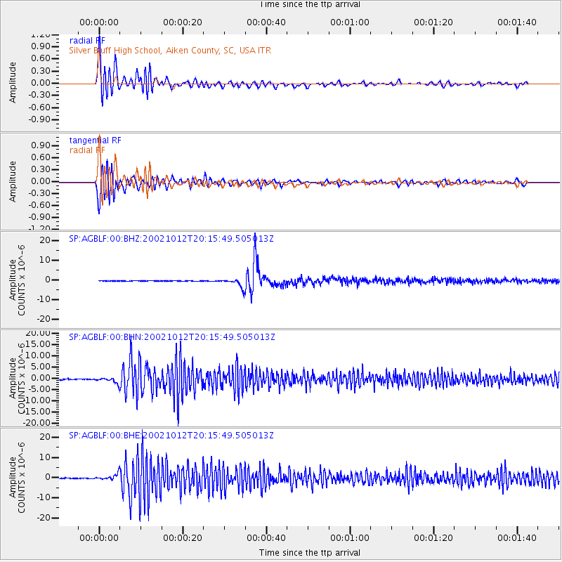
Signal To Noise
| Channel | StoN | STA | LTA |
| SP:AGBLF:00:BHN:20021012T20:15:49.505013Z | 7.856176 | 1.3372471E-6 | 1.7021604E-7 |
| SP:AGBLF:00:BHE:20021012T20:15:49.505013Z | 10.037241 | 1.5805392E-6 | 1.574675E-7 |
| SP:AGBLF:00:BHZ:20021012T20:15:49.505013Z | 21.692375 | 2.412972E-6 | 1.1123594E-7 |
| Arrivals |
| Ps | 2.5 SECOND |
| PpPs | 9.1 SECOND |
| PsPs/PpSs | 12 SECOND |


