You are here: Home > Network List > SP - South Carolina Earth Physics Project Stations List
> Station AGBLF Silver Bluff High School, Aiken County, SC, USA > Earthquake Result Viewer
AGBLF Silver Bluff High School, Aiken County, SC, USA - Earthquake Result Viewer

| Earthquake location: |
Central Alaska |
| Earthquake latitude/longitude: |
63.5/-147.4 |
| Earthquake time(UTC): |
2002/11/03 (307) 22:12:41 GMT |
| Earthquake Depth: |
4.9 km |
| Earthquake Magnitude: |
7.0 MB, 8.5 MS, 7.9 MW |
| Earthquake Catalog/Contributor: |
WHDF/NEIC |
|
| Network: |
SP South Carolina Earth Physics Project |
| Station: |
AGBLF Silver Bluff High School, Aiken County, SC, USA |
| Lat/Lon: |
33.40 N/81.76 W |
| Elevation: |
118 m |
|
| Distance: |
49.9 deg |
| Az: |
94.67 deg |
| Baz: |
327.715 deg |
| Ray Param: |
0.0684191 |
| Estimated Moho Depth: |
37.0 km |
| Estimated Crust Vp/Vs: |
1.68 |
| Assumed Crust Vp: |
6.565 km/s |
| Estimated Crust Vs: |
3.907 km/s |
| Estimated Crust Poisson's Ratio: |
0.23 |
|
| Radial Match: |
91.91074 % |
| Radial Bump: |
400 |
| Transverse Match: |
88.27928 % |
| Transverse Bump: |
400 |
| SOD ConfigId: |
2149 |
| Insert Time: |
2010-02-25 16:29:38.076 +0000 |
| GWidth: |
2.5 |
| Max Bumps: |
400 |
| Tol: |
0.001 |
|
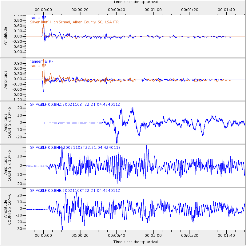
Signal To Noise
| Channel | StoN | STA | LTA |
| SP:AGBLF:00:BHN:20021103T22:21:04.424011Z | 7.726097 | 1.1966874E-6 | 1.54889E-7 |
| SP:AGBLF:00:BHE:20021103T22:21:04.424011Z | 11.982287 | 1.9867502E-6 | 1.6580725E-7 |
| SP:AGBLF:00:BHZ:20021103T22:21:04.424011Z | 12.911144 | 1.5730076E-6 | 1.2183332E-7 |
| Arrivals |
| Ps | 4.1 SECOND |
| PpPs | 14 SECOND |
| PsPs/PpSs | 18 SECOND |


