You are here: Home > Network List > KN - Kyrgyz Seismic Telemetry Network Stations List
> Station TKM KN.TKM > Earthquake Result Viewer
TKM KN.TKM - Earthquake Result Viewer
| Earthquake location: |
Off East Coast Of Honshu, Japan |
| Earthquake latitude/longitude: |
39.3/143.2 |
| Earthquake time(UTC): |
1992/07/16 (198) 00:00:40 GMT |
| Earthquake Depth: |
30 km |
| Earthquake Magnitude: |
5.5 MB, 5.8 MS |
| Earthquake Catalog/Contributor: |
WHDF/NEIC |
|
| Network: |
KN Kyrgyz Seismic Telemetry Network |
| Station: |
TKM KN.TKM |
| Lat/Lon: |
42.86 N/75.32 E |
| Elevation: |
960 m |
|
| Distance: |
50.0 deg |
| Az: |
297.267 deg |
| Baz: |
69.643 deg |
| Ray Param: |
0.0682589 |
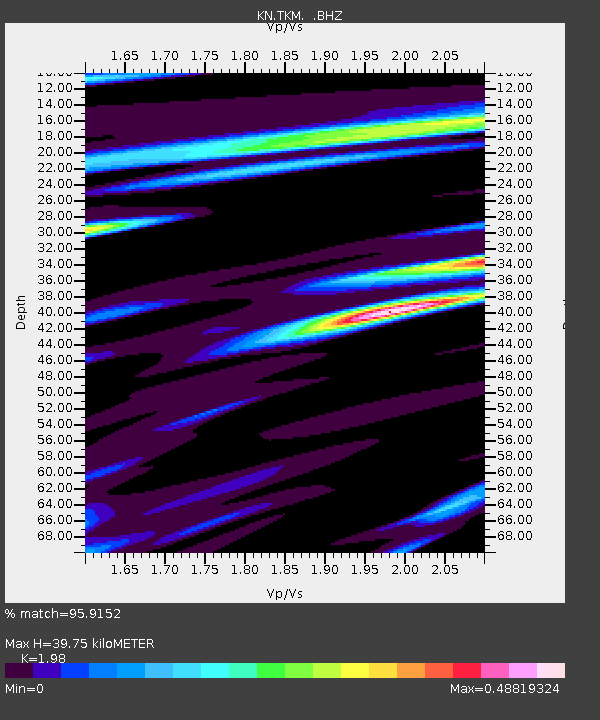
| Estimated Moho Depth: |
39.75 km |
| Estimated Crust Vp/Vs: |
1.98 |
| Assumed Crust Vp: |
6.306 km/s |
| Estimated Crust Vs: |
3.185 km/s |
| Estimated Crust Poisson's Ratio: |
0.33 |
|
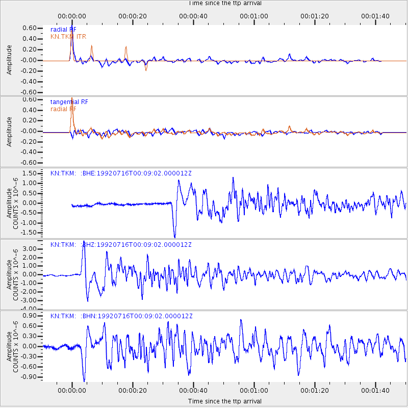
| Radial Match: |
95.9152 % |
| Radial Bump: |
352 |
| Transverse Match: |
89.39924 % |
| Transverse Bump: |
400 |
| SOD ConfigId: |
4480 |
| Insert Time: |
2010-03-08 20:46:33.410 +0000 |
| GWidth: |
2.5 |
| Max Bumps: |
400 |
| Tol: |
0.001 |
|
Signal To Noise
| Channel | StoN | STA | LTA |
| KN:TKM: :BHZ:19920716T00:09:02.000012Z | 26.270174 | 1.4781855E-6 | 5.626858E-8 |
| KN:TKM: :BHN:19920716T00:09:02.000012Z | 9.245183 | 3.6941657E-7 | 3.9957733E-8 |
| KN:TKM: :BHE:19920716T00:09:02.000012Z | 12.49786 | 6.0455824E-7 | 4.837294E-8 |
| Arrivals |
| Ps | 6.5 SECOND |
| PpPs | 18 SECOND |
| PsPs/PpSs | 24 SECOND |


