
Station KN TKM - KN.TKM
Network: KN - Kyrgyz Seismic Telemetry Network
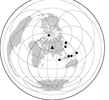
Nearby stations (2 deg radius)
| Station | Name | (Lat, Lon) | Start / End | Elevation |
| TKM | KN.TKM | (42.86, 75.32) | 1991-09-01 / 1994-08-30 | 960 m |
| Crust2 Type: | P4,orogen/50km, Urals, Tethian Orogen, Rockies 1 km seds. |
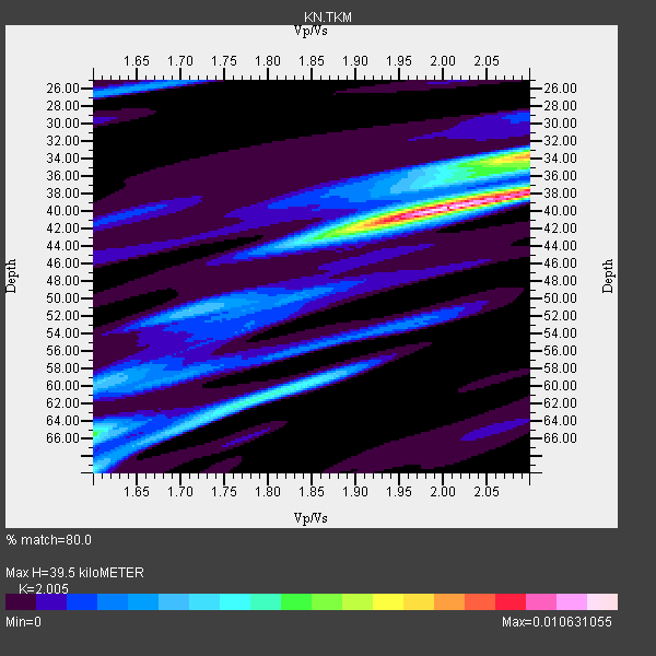
| Thickness Estimate: | 40 km |
| Thickness StdDev: | 8.5 km |
| Vp/Vs Estimate: | 2.01 |
| Vp/Vs StdDev: | 0.14 |
| Vs Estimate: | 3.145 km/s |
| Poisson's Ratio: | 0.33 |
| Peak Value: | 0.01 |
| Assumed Vp: | 6.306 km/s |
| Ps Weight: | 0.33333334 |
| PpPs Weight: | 0.33333334 |
| PsPs Weight: | 0.33333328 |
| Residual Complexity: | 0.626 |
| Nearby stations H: | +- |
| (2.0 deg) Vp/Vs: | +- |
11 with match > 90% ( 44.0 %) and 16 with match > 80% ( 64.0 %) out of 25.
Download stack as xyz text file.
Azimuth Distribution of Events:
Prior Results for this Station
| Study | Thickness | Vp/Vs | Vp | Vs | Poissons Ratio | Extra |
| EARS | 40 km | 2.01 | 6.306 km/s | 3.145 km/s | 0.33 | |
| Crust2.0 | 50 km | 1.76 | 6.306 km/s | 3.584 km/s | 0.26 | P4,orogen/50km, Urals, Tethian Orogen, Rockies 1 km seds. |
| Global Maxima | 40 km | 2.01 | 6.306 km/s | 3.145 km/s | 0.33 | amp=0.010631055 |
| Local Maxima 1 | 34 km | 2.09 | 6.306 km/s | 3.021 km/s | 0.35 | amp=0.0069440077 |
| Local Maxima 2 | 38 km | 2.10 | 6.306 km/s | 3.006 km/s | 0.35 | amp=0.0045354 |
| Local Maxima 3 | 62 km | 1.77 | 6.306 km/s | 3.568 km/s | 0.26 | amp=0.004467772 |
| Local Maxima 4 | 70 km | 1.60 | 6.306 km/s | 3.941 km/s | 0.18 | amp=0.0030345572 |
| Predicted Arrivals for vertical incidence (zero ray parameter) | |
| Ps | 6.30 SECOND |
| PpPs | 18.82 SECOND |
| PsPs/PpSs | 25.12 SECOND |
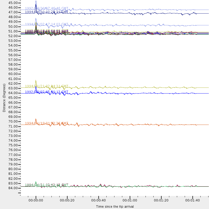
Events Processed for this Station
Download zip of receiver functions as SAC
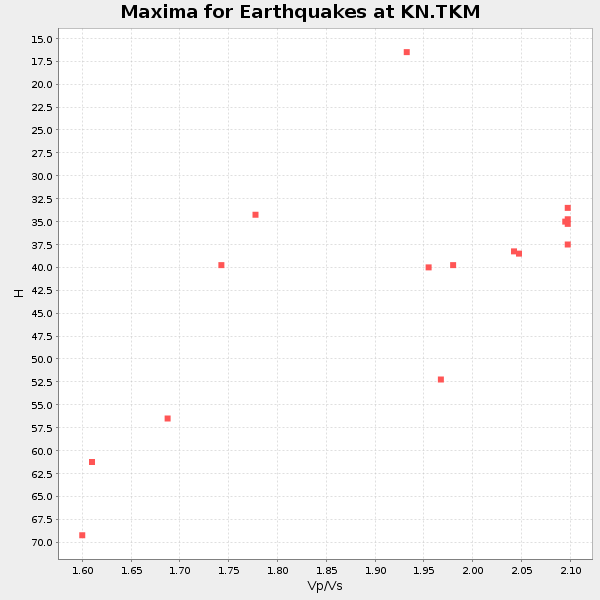
Plot maxima for each earthquake.
Events Used in the Stack
(16 events)| Radial Match | Distance | Baz | FERegion | Time | Lat/Lon | Depth | Magnitude |
| 98.290665 | 50.1 deg | 69.552 deg | Off East Coast Of Honshu, Japan | 1992/07/18 08:36:59 GMT | (39.4, 143.4) | 33 km | 6.1 MB, 6.9 MS |
| 97.76951 | 50.2 deg | 70.542 deg | Off East Coast Of Honshu, Japan | 1992/07/25 02:53:29 GMT | (38.6, 143.0) | 29 km | 5.9 MB, 5.6 MS, 5.4 UNKNOWN |
| 97.66033 | 50.2 deg | 69.387 deg | Off East Coast Of Honshu, Japan | 1992/07/29 04:30:49 GMT | (39.4, 143.5) | 29 km | 5.9 MB, 6.1 MS, 6.1 UNKNOWN |
| 97.62468 | 44.5 deg | 344.31 deg | Svalbard Region | 1992/07/20 07:46:46 GMT | (78.5, 5.1) | 10 km | 5.8 MB, 6.3 MS |
| 96.89207 | 49.6 deg | 69.302 deg | Near East Coast Of Honshu, Japan | 1992/07/18 08:39:06 GMT | (39.8, 142.9) | 36 km | 6.2 MB |
| 96.10383 | 49.8 deg | 69.592 deg | Off East Coast Of Honshu, Japan | 1992/07/18 13:56:53 GMT | (39.5, 143.0) | 21 km | 5.7 MB, 6.0 MS |
| 95.9152 | 50.0 deg | 69.643 deg | Off East Coast Of Honshu, Japan | 1992/07/16 00:00:40 GMT | (39.3, 143.2) | 30 km | 5.5 MB, 5.8 MS |
| 95.142395 | 85.7 deg | 101.803 deg | Solomon Islands | 1994/04/21 03:51:44 GMT | (-5.7, 154.1) | 30 km | 5.8 MB, 6.6 MS, 6.7 UNKNOWN, 6.6 MW |
| 94.60484 | 71.2 deg | 113.133 deg | Irian Jaya, Indonesia | 1994/01/19 01:53:36 GMT | (-3.2, 136.0) | 33 km | 6.0 MB, 6.9 MS, 6.9 UNKNOWN |
| 94.328354 | 62.6 deg | 116.813 deg | Halmahera, Indonesia | 1994/01/21 02:24:31 GMT | (1.0, 127.7) | 33 km | 7.2 MS, 7.0 UNKNOWN |
| 90.74953 | 45.3 deg | 85.535 deg | Kyushu, Japan | 1994/04/30 03:28:39 GMT | (31.3, 131.2) | 30 km | 5.6 MB, 5.3 MS, 5.1 UNKNOWN, 5.8 MW |
| 89.53847 | 63.9 deg | 118.317 deg | Halmahera, Indonesia | 1992/08/02 05:50:13 GMT | (-0.9, 127.6) | 33 km | 5.8 MB, 6.2 MS, 6.6 UNKNOWN |
| 89.15631 | 48.2 deg | 149.396 deg | Southwest Of Sumatra, Indonesia | 1994/05/02 17:14:03 GMT | (-1.1, 97.6) | 38 km | 6.1 MB, 5.8 MS, 5.6 UNKNOWN, 6.0 MW |
| 88.8648 | 49.9 deg | 69.657 deg | Off East Coast Of Honshu, Japan | 1992/07/18 10:20:12 GMT | (39.4, 143.1) | 32 km | 6.0 MB, 6.3 MS |
| 82.634865 | 50.2 deg | 69.935 deg | Off East Coast Of Honshu, Japan | 1992/07/18 12:02:40 GMT | (39.1, 143.2) | 25 km | 5.5 MB, 5.4 MS |
| 82.25165 | 85.6 deg | 101.764 deg | Solomon Islands | 1994/04/21 02:42:15 GMT | (-5.6, 154.1) | 39 km | 5.4 MB, 5.6 MS |
Losers
(9 events)| Radial Match | Distance | Baz | FERegion | Time | Lat/Lon | Depth | Magnitude | Reason |
| 75.3189 | 65.5 deg | 122.81 deg | Banda Sea | 1992/07/14 07:03:10 GMT | (-4.7, 125.4) | 477 km | 5.6 MB | |
| 74.81716 | 65.2 deg | 127.64 deg | Flores Sea | 1992/08/02 12:03:20 GMT | (-7.1, 121.7) | 483 km | 6.2 MB | |
| 64.327484 | 50.0 deg | 69.565 deg | Off East Coast Of Honshu, Japan | 1992/07/18 10:59:39 GMT | (39.4, 143.3) | 28 km | 5.5 MB, 5.9 MS | |
| 61.92911 | 50.0 deg | 82.502 deg | Southeast Of Honshu, Japan | 1992/07/18 21:36:24 GMT | (30.8, 137.3) | 475 km | 5.5 MB | |
| 59.023285 | 83.6 deg | 105.641 deg | New Britain Region, P.N.G. | 1992/07/24 02:09:23 GMT | (-7.0, 149.9) | 44 km | 5.7 MB, 5.5 MS | |
| 58.773273 | 93.7 deg | 12.792 deg | Oregon | 1993/09/21 05:45:34 GMT | (42.4, -122.0) | 5.0 km | 5.5 MB, 5.7 MS, 5.9 UNKNOWN, 6.0 MD | |
| 58.31163 | 66.4 deg | 128.933 deg | Flores Region, Indonesia | 1992/07/15 18:04:17 GMT | (-8.8, 121.5) | 116 km | 5.7 MB | |
| 56.677757 | 54.0 deg | 144.11 deg | Southern Sumatra, Indonesia | 1994/01/21 18:00:17 GMT | (-4.8, 103.7) | 89 km | 6.0 MB | |
| 38.94036 | 44.7 deg | 286.527 deg | Southern Italy | 1994/01/05 13:24:11 GMT | (39.2, 15.2) | 291 km | 5.9 MB, 6.0 UNKNOWN, 5.9 MW |
