You are here: Home > Network List > KN - Kyrgyz Seismic Telemetry Network Stations List
> Station TKM KN.TKM > Earthquake Result Viewer
TKM KN.TKM - Earthquake Result Viewer

| Earthquake location: |
Off East Coast Of Honshu, Japan |
| Earthquake latitude/longitude: |
39.4/143.4 |
| Earthquake time(UTC): |
1992/07/18 (200) 08:36:59 GMT |
| Earthquake Depth: |
33 km |
| Earthquake Magnitude: |
6.1 MB, 6.9 MS |
| Earthquake Catalog/Contributor: |
WHDF/NEIC |
|
| Network: |
KN Kyrgyz Seismic Telemetry Network |
| Station: |
TKM KN.TKM |
| Lat/Lon: |
42.86 N/75.32 E |
| Elevation: |
960 m |
|
| Distance: |
50.1 deg |
| Az: |
297.29 deg |
| Baz: |
69.552 deg |
| Ray Param: |
0.068201184 |
| Estimated Moho Depth: |
38.5 km |
| Estimated Crust Vp/Vs: |
2.05 |
| Assumed Crust Vp: |
6.306 km/s |
| Estimated Crust Vs: |
3.08 km/s |
| Estimated Crust Poisson's Ratio: |
0.34 |
|
| Radial Match: |
98.290665 % |
| Radial Bump: |
314 |
| Transverse Match: |
94.935905 % |
| Transverse Bump: |
400 |
| SOD ConfigId: |
4480 |
| Insert Time: |
2010-03-08 20:46:35.320 +0000 |
| GWidth: |
2.5 |
| Max Bumps: |
400 |
| Tol: |
0.001 |
|
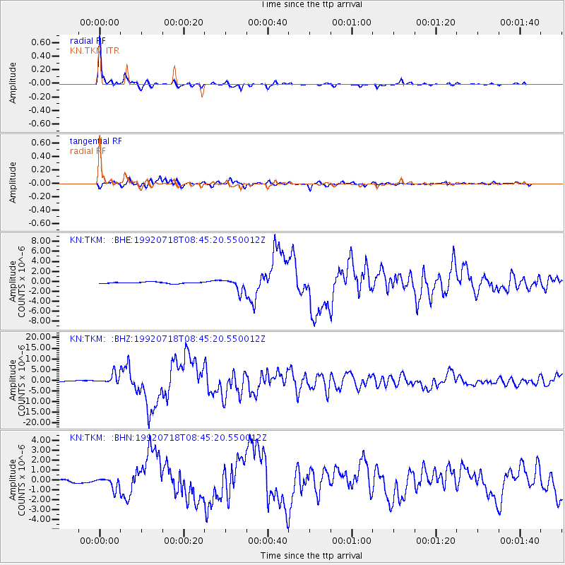
Signal To Noise
| Channel | StoN | STA | LTA |
| KN:TKM: :BHZ:19920718T08:45:20.550012Z | 10.463586 | 2.588385E-6 | 2.4737074E-7 |
| KN:TKM: :BHN:19920718T08:45:20.550012Z | 4.656786 | 6.1875824E-7 | 1.3287237E-7 |
| KN:TKM: :BHE:19920718T08:45:20.550012Z | 9.1042385 | 1.3034004E-6 | 1.4316414E-7 |
| Arrivals |
| Ps | 6.7 SECOND |
| PpPs | 18 SECOND |
| PsPs/PpSs | 24 SECOND |


