You are here: Home > Network List > KN - Kyrgyz Seismic Telemetry Network Stations List
> Station TKM KN.TKM > Earthquake Result Viewer
TKM KN.TKM - Earthquake Result Viewer
| Earthquake location: |
Near East Coast Of Honshu, Japan |
| Earthquake latitude/longitude: |
39.8/142.9 |
| Earthquake time(UTC): |
1992/07/18 (200) 08:39:06 GMT |
| Earthquake Depth: |
36 km |
| Earthquake Magnitude: |
6.2 MB |
| Earthquake Catalog/Contributor: |
WHDF/NEIC |
|
| Network: |
KN Kyrgyz Seismic Telemetry Network |
| Station: |
TKM KN.TKM |
| Lat/Lon: |
42.86 N/75.32 E |
| Elevation: |
960 m |
|
| Distance: |
49.6 deg |
| Az: |
296.841 deg |
| Baz: |
69.302 deg |
| Ray Param: |
0.06850459 |
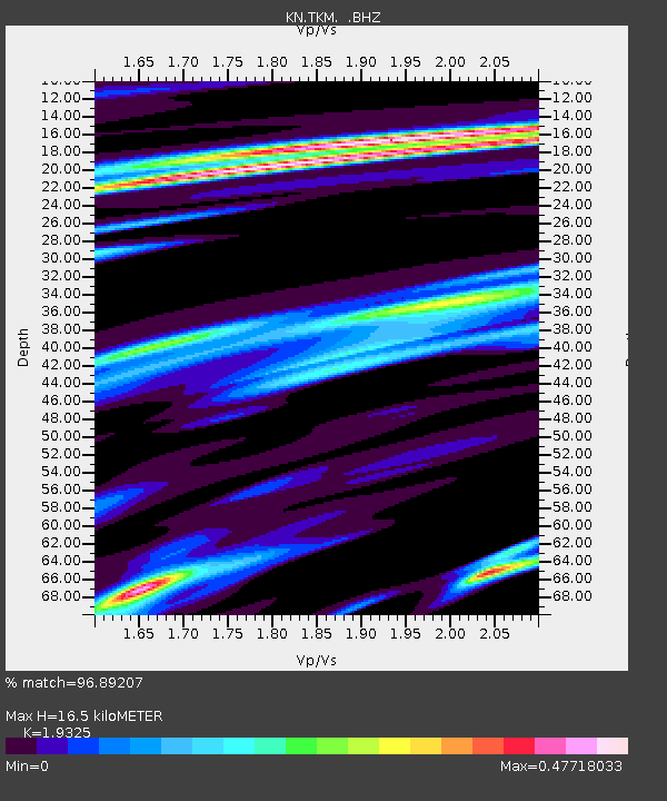
| Estimated Moho Depth: |
16.5 km |
| Estimated Crust Vp/Vs: |
1.93 |
| Assumed Crust Vp: |
6.306 km/s |
| Estimated Crust Vs: |
3.263 km/s |
| Estimated Crust Poisson's Ratio: |
0.32 |
|
| Radial Match: |
96.89207 % |
| Radial Bump: |
352 |
| Transverse Match: |
86.43695 % |
| Transverse Bump: |
400 |
| SOD ConfigId: |
4480 |
| Insert Time: |
2010-03-08 20:46:36.495 +0000 |
| GWidth: |
2.5 |
| Max Bumps: |
400 |
| Tol: |
0.001 |
|
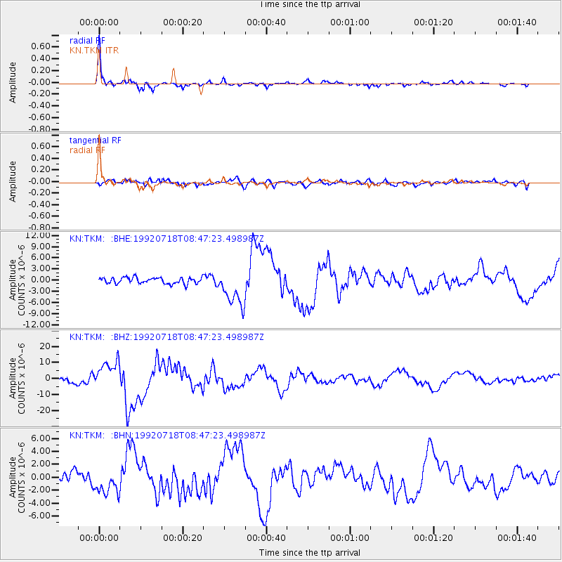
Signal To Noise
| Channel | StoN | STA | LTA |
| KN:TKM: :BHZ:19920718T08:47:23.498987Z | 4.9499216 | 8.806079E-6 | 1.779034E-6 |
| KN:TKM: :BHN:19920718T08:47:23.498987Z | 1.530078 | 1.943995E-6 | 1.27052E-6 |
| KN:TKM: :BHE:19920718T08:47:23.498987Z | 6.3906054 | 5.1977795E-6 | 8.13347E-7 |
| Arrivals |
| Ps | 2.6 SECOND |
| PpPs | 7.3 SECOND |
| PsPs/PpSs | 9.9 SECOND |


