You are here: Home > Network List > KN - Kyrgyz Seismic Telemetry Network Stations List
> Station TKM KN.TKM > Earthquake Result Viewer
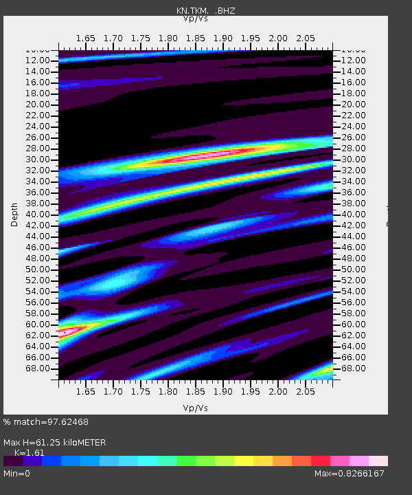
TKM KN.TKM - Earthquake Result Viewer
| Earthquake location: |
Svalbard Region |
| Earthquake latitude/longitude: |
78.5/5.1 |
| Earthquake time(UTC): |
1992/07/20 (202) 07:46:46 GMT |
| Earthquake Depth: |
10 km |
| Earthquake Magnitude: |
5.8 MB, 6.3 MS |
| Earthquake Catalog/Contributor: |
WHDF/NEIC |
|
| Network: |
KN Kyrgyz Seismic Telemetry Network |
| Station: |
TKM KN.TKM |
| Lat/Lon: |
42.86 N/75.32 E |
| Elevation: |
960 m |
|
| Distance: |
44.5 deg |
| Az: |
98.776 deg |
| Baz: |
344.31 deg |
| Ray Param: |
0.07190857 |
| Estimated Moho Depth: |
61.25 km |
| Estimated Crust Vp/Vs: |
1.61 |
| Assumed Crust Vp: |
6.306 km/s |
| Estimated Crust Vs: |
3.917 km/s |
| Estimated Crust Poisson's Ratio: |
0.19 |
|
| Radial Match: |
97.62468 % |
| Radial Bump: |
322 |
| Transverse Match: |
83.23487 % |
| Transverse Bump: |
400 |
| SOD ConfigId: |
4480 |
| Insert Time: |
2010-03-08 20:46:40.043 +0000 |
| GWidth: |
2.5 |
| Max Bumps: |
400 |
| Tol: |
0.001 |
|

Signal To Noise
| Channel | StoN | STA | LTA |
| KN:TKM: :BHZ:19920720T07:54:26.800012Z | 2.988672 | 1.6740148E-7 | 5.6012E-8 |
| KN:TKM: :BHN:19920720T07:54:26.800012Z | 2.0799885 | 1.0386647E-7 | 4.993608E-8 |
| KN:TKM: :BHE:19920720T07:54:26.800012Z | 0.66209406 | 5.1273723E-8 | 7.744175E-8 |
| Arrivals |
| Ps | 6.3 SECOND |
| PpPs | 24 SECOND |
| PsPs/PpSs | 30 SECOND |


