You are here: Home > Network List > KN - Kyrgyz Seismic Telemetry Network Stations List
> Station TKM KN.TKM > Earthquake Result Viewer
TKM KN.TKM - Earthquake Result Viewer
| Earthquake location: |
Halmahera, Indonesia |
| Earthquake latitude/longitude: |
1.0/127.7 |
| Earthquake time(UTC): |
1994/01/21 (021) 02:24:31 GMT |
| Earthquake Depth: |
33 km |
| Earthquake Magnitude: |
7.2 MS, 7.0 UNKNOWN |
| Earthquake Catalog/Contributor: |
WHDF/NEIC |
|
| Network: |
KN Kyrgyz Seismic Telemetry Network |
| Station: |
TKM KN.TKM |
| Lat/Lon: |
42.86 N/75.32 E |
| Elevation: |
960 m |
|
| Distance: |
62.6 deg |
| Az: |
318.979 deg |
| Baz: |
116.813 deg |
| Ray Param: |
0.060070775 |
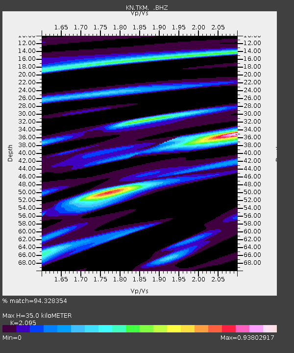
| Estimated Moho Depth: |
35.0 km |
| Estimated Crust Vp/Vs: |
2.10 |
| Assumed Crust Vp: |
6.306 km/s |
| Estimated Crust Vs: |
3.01 km/s |
| Estimated Crust Poisson's Ratio: |
0.35 |
|
| Radial Match: |
94.328354 % |
| Radial Bump: |
400 |
| Transverse Match: |
82.524254 % |
| Transverse Bump: |
400 |
| SOD ConfigId: |
4480 |
| Insert Time: |
2010-03-08 20:46:48.037 +0000 |
| GWidth: |
2.5 |
| Max Bumps: |
400 |
| Tol: |
0.001 |
|
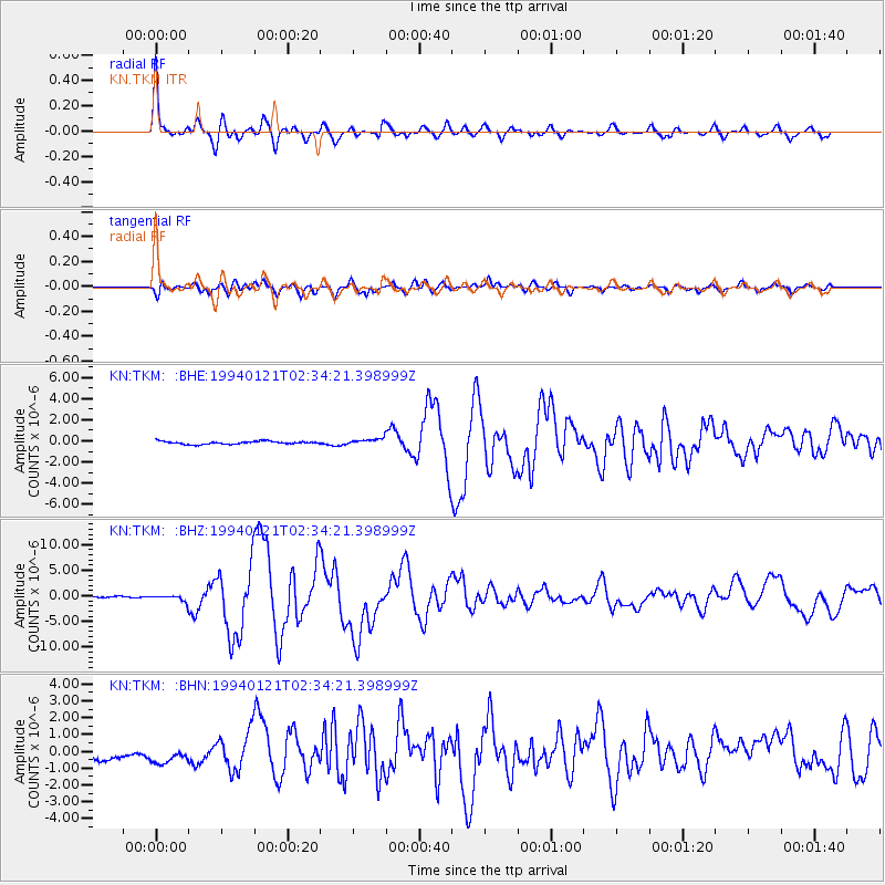
Signal To Noise
| Channel | StoN | STA | LTA |
| KN:TKM: :BHZ:19940121T02:34:21.398999Z | 4.7325497 | 6.4053677E-7 | 1.3534708E-7 |
| KN:TKM: :BHN:19940121T02:34:21.398999Z | 1.448975 | 5.2108226E-7 | 3.596213E-7 |
| KN:TKM: :BHE:19940121T02:34:21.398999Z | 2.2875319 | 3.0360408E-7 | 1.3272125E-7 |
| Arrivals |
| Ps | 6.3 SECOND |
| PpPs | 17 SECOND |
| PsPs/PpSs | 23 SECOND |


