You are here: Home > Network List > KN - Kyrgyz Seismic Telemetry Network Stations List
> Station TKM KN.TKM > Earthquake Result Viewer
TKM KN.TKM - Earthquake Result Viewer
| Earthquake location: |
Solomon Islands |
| Earthquake latitude/longitude: |
-5.6/154.1 |
| Earthquake time(UTC): |
1994/04/21 (111) 02:42:15 GMT |
| Earthquake Depth: |
39 km |
| Earthquake Magnitude: |
5.4 MB, 5.6 MS |
| Earthquake Catalog/Contributor: |
WHDF/NEIC |
|
| Network: |
KN Kyrgyz Seismic Telemetry Network |
| Station: |
TKM KN.TKM |
| Lat/Lon: |
42.86 N/75.32 E |
| Elevation: |
960 m |
|
| Distance: |
85.6 deg |
| Az: |
313.674 deg |
| Baz: |
101.764 deg |
| Ray Param: |
0.044599347 |
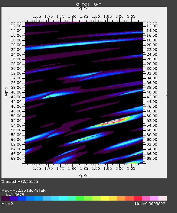
| Estimated Moho Depth: |
52.25 km |
| Estimated Crust Vp/Vs: |
1.97 |
| Assumed Crust Vp: |
6.306 km/s |
| Estimated Crust Vs: |
3.205 km/s |
| Estimated Crust Poisson's Ratio: |
0.33 |
|
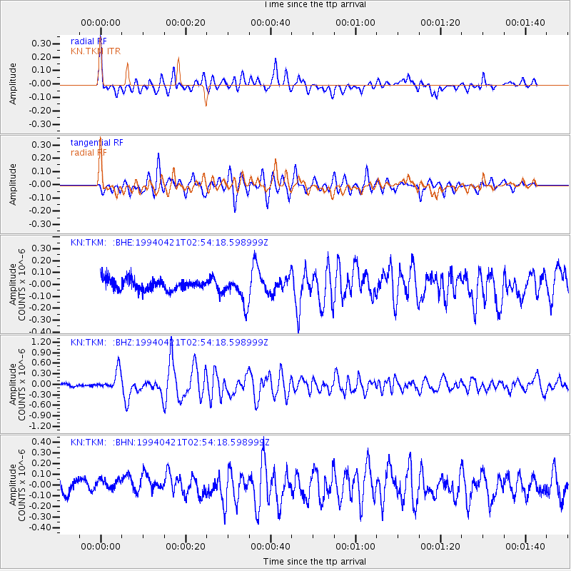
| Radial Match: |
82.25165 % |
| Radial Bump: |
400 |
| Transverse Match: |
74.299904 % |
| Transverse Bump: |
400 |
| SOD ConfigId: |
4480 |
| Insert Time: |
2010-03-08 20:46:48.979 +0000 |
| GWidth: |
2.5 |
| Max Bumps: |
400 |
| Tol: |
0.001 |
|
Signal To Noise
| Channel | StoN | STA | LTA |
| KN:TKM: :BHZ:19940421T02:54:18.598999Z | 4.70444 | 2.870203E-7 | 6.101051E-8 |
| KN:TKM: :BHN:19940421T02:54:18.598999Z | 1.4431919 | 8.183548E-8 | 5.6704504E-8 |
| KN:TKM: :BHE:19940421T02:54:18.598999Z | 2.5371537 | 1.1688257E-7 | 4.606838E-8 |
| Arrivals |
| Ps | 8.2 SECOND |
| PpPs | 24 SECOND |
| PsPs/PpSs | 32 SECOND |


