You are here: Home > Network List > KR - Kyrgyz Digital Network Stations List
> Station MNAS Manas, Kyrgyzstan > Earthquake Result Viewer
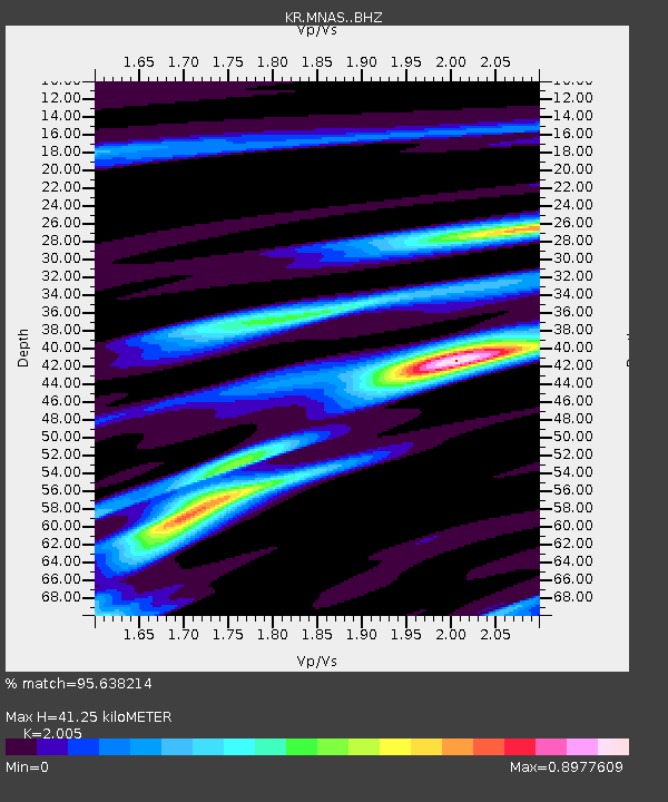
MNAS Manas, Kyrgyzstan - Earthquake Result Viewer
| Earthquake location: |
Ryukyu Islands, Japan |
| Earthquake latitude/longitude: |
28.9/128.3 |
| Earthquake time(UTC): |
2020/06/13 (165) 15:51:23 GMT |
| Earthquake Depth: |
160 km |
| Earthquake Magnitude: |
6.6 Mww |
| Earthquake Catalog/Contributor: |
NEIC PDE/us |
|
| Network: |
KR Kyrgyz Digital Network |
| Station: |
MNAS Manas, Kyrgyzstan |
| Lat/Lon: |
42.49 N/72.50 E |
| Elevation: |
1465 m |
|
| Distance: |
46.5 deg |
| Az: |
302.5 deg |
| Baz: |
88.09 deg |
| Ray Param: |
0.070033744 |
| Estimated Moho Depth: |
41.25 km |
| Estimated Crust Vp/Vs: |
2.01 |
| Assumed Crust Vp: |
6.316 km/s |
| Estimated Crust Vs: |
3.15 km/s |
| Estimated Crust Poisson's Ratio: |
0.33 |
|
| Radial Match: |
95.638214 % |
| Radial Bump: |
249 |
| Transverse Match: |
80.98064 % |
| Transverse Bump: |
400 |
| SOD ConfigId: |
21709731 |
| Insert Time: |
2020-06-27 16:08:44.249 +0000 |
| GWidth: |
2.5 |
| Max Bumps: |
400 |
| Tol: |
0.001 |
|

Signal To Noise
| Channel | StoN | STA | LTA |
| KR:MNAS: :BHZ:20200613T15:59:03.779987Z | 38.114914 | 2.487427E-6 | 6.5261254E-8 |
| KR:MNAS: :BHN:20200613T15:59:03.779987Z | 17.88084 | 3.624044E-7 | 2.026775E-8 |
| KR:MNAS: :BHE:20200613T15:59:03.779987Z | 52.768147 | 1.3463139E-6 | 2.5513762E-8 |
| Arrivals |
| Ps | 6.9 SECOND |
| PpPs | 19 SECOND |
| PsPs/PpSs | 26 SECOND |


