You are here: Home > Network List > AK - Alaska Regional Network Stations List
> Station BERG Berg Lake, AK, USA > Earthquake Result Viewer
BERG Berg Lake, AK, USA - Earthquake Result Viewer
| Earthquake location: |
South Of Kermadec Islands |
| Earthquake latitude/longitude: |
-33.2/-178.0 |
| Earthquake time(UTC): |
2020/06/18 (170) 15:06:15 GMT |
| Earthquake Depth: |
10 km |
| Earthquake Magnitude: |
5.5 mb |
| Earthquake Catalog/Contributor: |
NEIC PDE/us |
|
| Network: |
AK Alaska Regional Network |
| Station: |
BERG Berg Lake, AK, USA |
| Lat/Lon: |
60.39 N/143.70 W |
| Elevation: |
474 m |
|
| Distance: |
97.4 deg |
| Az: |
16.378 deg |
| Baz: |
208.444 deg |
| Ray Param: |
0.040236123 |
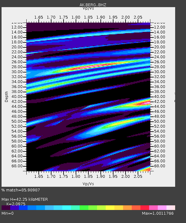
| Estimated Moho Depth: |
42.25 km |
| Estimated Crust Vp/Vs: |
2.10 |
| Assumed Crust Vp: |
6.566 km/s |
| Estimated Crust Vs: |
3.13 km/s |
| Estimated Crust Poisson's Ratio: |
0.35 |
|
| Radial Match: |
85.98987 % |
| Radial Bump: |
400 |
| Transverse Match: |
76.26103 % |
| Transverse Bump: |
400 |
| SOD ConfigId: |
21709731 |
| Insert Time: |
2020-07-02 15:06:56.697 +0000 |
| GWidth: |
2.5 |
| Max Bumps: |
400 |
| Tol: |
0.001 |
|

Signal To Noise
| Channel | StoN | STA | LTA |
| AK:BERG: :BHZ:20200618T15:19:17.208018Z | 2.1507945 | 2.4622025E-6 | 1.1447873E-6 |
| AK:BERG: :BHN:20200618T15:19:17.208018Z | 1.3655342 | 1.3005222E-6 | 9.523908E-7 |
| AK:BERG: :BHE:20200618T15:19:17.208018Z | 1.3002541 | 1.5778659E-6 | 1.2135058E-6 |
| Arrivals |
| Ps | 7.2 SECOND |
| PpPs | 20 SECOND |
| PsPs/PpSs | 27 SECOND |


