You are here: Home > Network List > SP - South Carolina Earth Physics Project Stations List
> Station ANDY Andrews High School, Georgetown County, SC USA > Earthquake Result Viewer
ANDY Andrews High School, Georgetown County, SC USA - Earthquake Result Viewer
| Earthquake location: |
Near Coast Of Central Chile |
| Earthquake latitude/longitude: |
-30.6/-71.6 |
| Earthquake time(UTC): |
2003/06/20 (171) 13:30:41 GMT |
| Earthquake Depth: |
33 km |
| Earthquake Magnitude: |
6.4 MB, 6.8 MS, 6.8 MW, 6.7 MW |
| Earthquake Catalog/Contributor: |
WHDF/NEIC |
|
| Network: |
SP South Carolina Earth Physics Project |
| Station: |
ANDY Andrews High School, Georgetown County, SC USA |
| Lat/Lon: |
33.46 N/79.57 W |
| Elevation: |
49 m |
|
| Distance: |
64.2 deg |
| Az: |
352.634 deg |
| Baz: |
172.401 deg |
| Ray Param: |
0.059045367 |
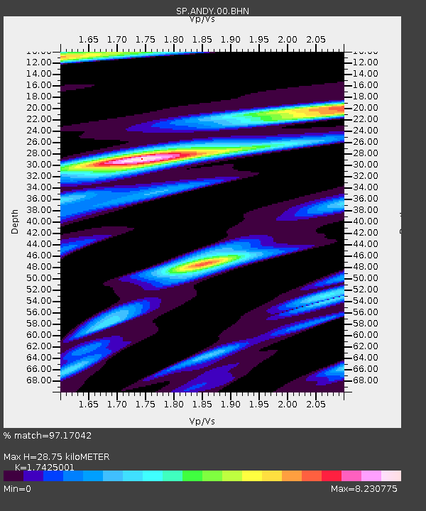
| Estimated Moho Depth: |
28.75 km |
| Estimated Crust Vp/Vs: |
1.74 |
| Assumed Crust Vp: |
6.24 km/s |
| Estimated Crust Vs: |
3.581 km/s |
| Estimated Crust Poisson's Ratio: |
0.25 |
|
| Radial Match: |
97.17042 % |
| Radial Bump: |
400 |
| Transverse Match: |
84.88979 % |
| Transverse Bump: |
400 |
| SOD ConfigId: |
2174 |
| Insert Time: |
2010-02-25 16:30:00.581 +0000 |
| GWidth: |
2.5 |
| Max Bumps: |
400 |
| Tol: |
0.001 |
|

Signal To Noise
| Channel | StoN | STA | LTA |
| SP:ANDY:00:BHN:20030620T13:40:42.090012Z | 1.2958233 | 6.299417E-7 | 4.861324E-7 |
| SP:ANDY:00:BHE:20030620T13:40:42.090012Z | 0.47297037 | 2.872217E-7 | 6.0727206E-7 |
| SP:ANDY:00:BHZ:20030620T13:40:42.090012Z | 3.032461 | 3.1277517E-7 | 1.03142355E-7 |
| Arrivals |
| Ps | 3.6 SECOND |
| PpPs | 12 SECOND |
| PsPs/PpSs | 16 SECOND |


