
Station SP ANDY - Andrews High School, Georgetown County, SC USA
Network: SP - South Carolina Earth Physics Project
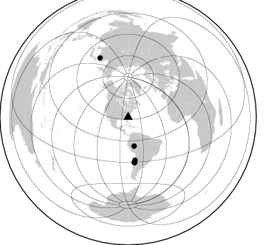
Nearby stations (2 deg radius)
| Station | Name | (Lat, Lon) | Start / End | Elevation |
| ANDY | Andrews High School, Georgetown County, SC USA | (33.46, -79.57) | 2002-03-18 / 2499-01-01 | 49 m |
| Crust2 Type: | C2,continental shelf, 1 km seds. |
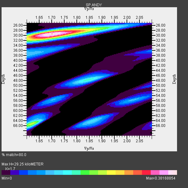
| Thickness Estimate: | 29 km |
| Thickness StdDev: | 9.6 km |
| Vp/Vs Estimate: | 1.70 |
| Vp/Vs StdDev: | 0.08 |
| Vs Estimate: | 3.671 km/s |
| Poisson's Ratio: | 0.24 |
| Peak Value: | 0.38 |
| Assumed Vp: | 6.24 km/s |
| Ps Weight: | 0.33333334 |
| PpPs Weight: | 0.33333334 |
| PsPs Weight: | 0.33333328 |
| Residual Complexity: | 0.564 |
| Nearby stations H: | +- |
| (2.0 deg) Vp/Vs: | +- |
4 with match > 90% ( 66.666664 %) and 5 with match > 80% ( 83.333336 %) out of 6.
Download stack as xyz text file.
Azimuth Distribution of Events:
Prior Results for this Station
| Study | Thickness | Vp/Vs | Vp | Vs | Poissons Ratio | Extra |
| EARS | 29 km | 1.70 | 6.24 km/s | 3.671 km/s | 0.24 | |
| Crust2.0 | 30 km | 1.80 | 6.24 km/s | 3.467 km/s | 0.28 | C2,continental shelf, 1 km seds. |
| Global Maxima | 29 km | 1.70 | 6.24 km/s | 3.671 km/s | 0.24 | amp=0.38168854 |
| Local Maxima 1 | 65 km | 1.62 | 6.24 km/s | 3.846 km/s | 0.19 | amp=0.22584622 |
| Local Maxima 2 | 30 km | 1.72 | 6.24 km/s | 3.638 km/s | 0.24 | amp=0.18357284 |
| Local Maxima 3 | 48 km | 1.85 | 6.24 km/s | 3.382 km/s | 0.29 | amp=0.15595636 |
| Local Maxima 4 | 64 km | 1.86 | 6.24 km/s | 3.355 km/s | 0.30 | amp=0.12359117 |
| Predicted Arrivals for vertical incidence (zero ray parameter) | |
| Ps | 3.28 SECOND |
| PpPs | 12.66 SECOND |
| PsPs/PpSs | 15.94 SECOND |
Events Processed for this Station
Download zip of receiver functions as SAC
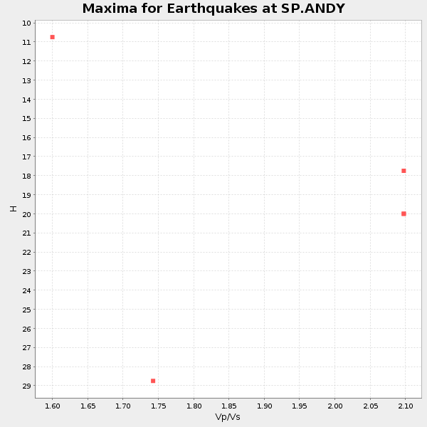
Plot maxima for each earthquake.
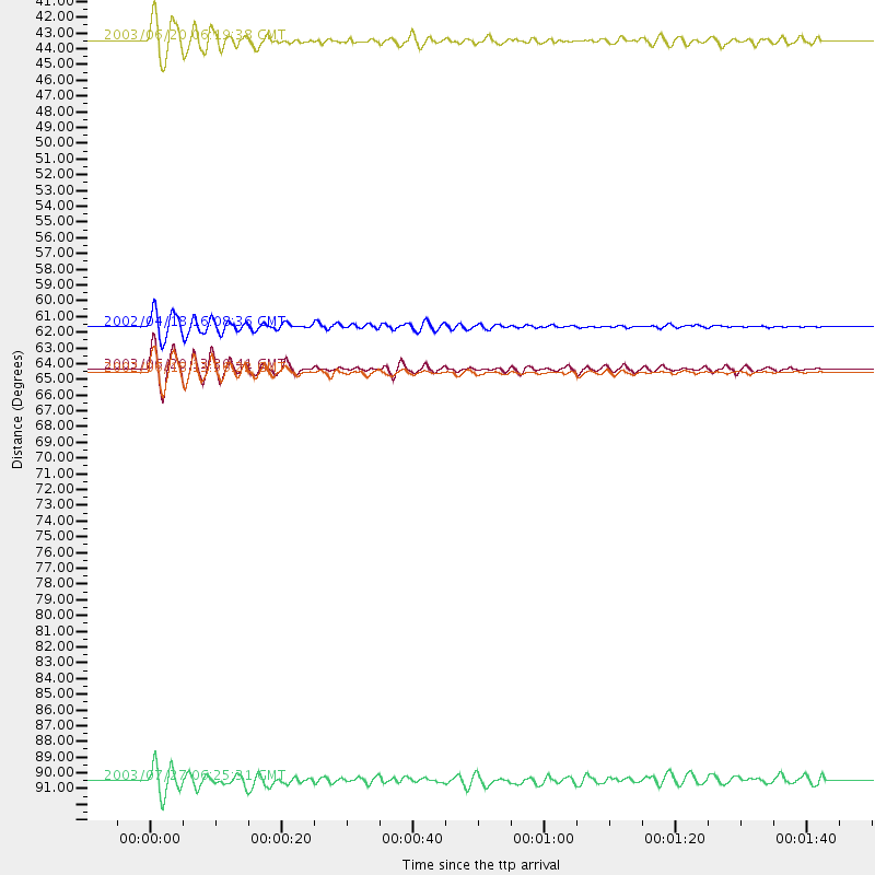
Events Used in the Stack
(5 events)| Radial Match | Distance | Baz | FERegion | Time | Lat/Lon | Depth | Magnitude |
| 97.17042 | 64.2 deg | 172.401 deg | Near Coast Of Central Chile | 2003/06/20 13:30:41 GMT | (-30.6, -71.6) | 33 km | 6.4 MB, 6.8 MS, 6.8 MW, 6.7 MW |
| 94.95078 | 64.4 deg | 171.944 deg | Near Coast Of Central Chile | 2002/06/18 13:56:22 GMT | (-30.8, -71.1) | 54 km | 6.0 MB, 6.6 MW, 6.4 MW |
| 91.76713 | 61.3 deg | 170.899 deg | Near Coast Of Northern Chile | 2002/04/18 16:08:36 GMT | (-27.5, -70.6) | 62 km | 6.2 MB, 6.7 MW, 6.6 MW |
| 90.43881 | 41.5 deg | 168.214 deg | Western Brazil | 2003/06/20 06:19:38 GMT | (-7.6, -71.7) | 558 km | 6.4 MB, 7.1 MW, 7.0 MW |
| 81.2934 | 92.5 deg | 334.643 deg | Primor'ye, Russia | 2003/07/27 06:25:31 GMT | (47.2, 139.2) | 470 km | 6.3 MB, 6.8 MW, 6.8 MW |
Losers
(1 events)| Radial Match | Distance | Baz | FERegion | Time | Lat/Lon | Depth | Magnitude | Reason |
| 93.259445 | 77.9 deg | 329.872 deg | Kamchatka Peninsula, Russia | 2003/06/16 22:08:02 GMT | (55.5, 160.0) | 175 km | 6.3 MB, 6.9 MW, 6.9 MW |
