You are here: Home > Network List > SP - South Carolina Earth Physics Project Stations List
> Station BBLV Batesburg-Leesville High School, Lexington County, SC USA > Earthquake Result Viewer
BBLV Batesburg-Leesville High School, Lexington County, SC USA - Earthquake Result Viewer
| Earthquake location: |
Queen Charlotte Islands Region |
| Earthquake latitude/longitude: |
52.6/-132.2 |
| Earthquake time(UTC): |
2001/10/12 (285) 05:02:34 GMT |
| Earthquake Depth: |
20 km |
| Earthquake Magnitude: |
5.6 MB, 5.8 MS, 6.2 MW, 6.1 MW |
| Earthquake Catalog/Contributor: |
WHDF/NEIC |
|
| Network: |
SP South Carolina Earth Physics Project |
| Station: |
BBLV Batesburg-Leesville High School, Lexington County, SC USA |
| Lat/Lon: |
33.92 N/81.53 W |
| Elevation: |
198 m |
|
| Distance: |
40.4 deg |
| Az: |
97.023 deg |
| Baz: |
313.319 deg |
| Ray Param: |
0.07440474 |
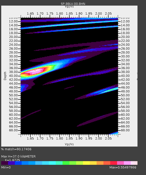
| Estimated Moho Depth: |
37.0 km |
| Estimated Crust Vp/Vs: |
1.67 |
| Assumed Crust Vp: |
6.565 km/s |
| Estimated Crust Vs: |
3.925 km/s |
| Estimated Crust Poisson's Ratio: |
0.22 |
|
| Radial Match: |
90.17406 % |
| Radial Bump: |
337 |
| Transverse Match: |
70.75712 % |
| Transverse Bump: |
400 |
| SOD ConfigId: |
2186 |
| Insert Time: |
2010-02-25 16:35:08.093 +0000 |
| GWidth: |
2.5 |
| Max Bumps: |
400 |
| Tol: |
0.001 |
|

Signal To Noise
| Channel | StoN | STA | LTA |
| SP:BBLV:00:BHN:20011012T05:09:39.78299Z | 2.2835755 | 2.878968E-7 | 1.2607282E-7 |
| SP:BBLV:00:BHE:20011012T05:09:39.78299Z | 1.048141 | 1.3045369E-7 | 1.2446196E-7 |
| SP:BBLV:00:BHZ:20011012T05:09:39.78299Z | 4.4243 | 3.1566265E-7 | 7.134748E-8 |
| Arrivals |
| Ps | 4.1 SECOND |
| PpPs | 14 SECOND |
| PsPs/PpSs | 18 SECOND |


