
Station SP BBLV - Batesburg-Leesville High School, Lexington County, SC USA
Network: SP - South Carolina Earth Physics Project
Nearby stations (2 deg radius)
| Station | Name | (Lat, Lon) | Start / End | Elevation |
| BBLV | Batesburg-Leesville High School, Lexington County, SC USA | (33.92, -81.53) | 2001-09-11 / 2499-01-01 | 198 m |
| Crust2 Type: | DG,thin Platform 1 km seds. |
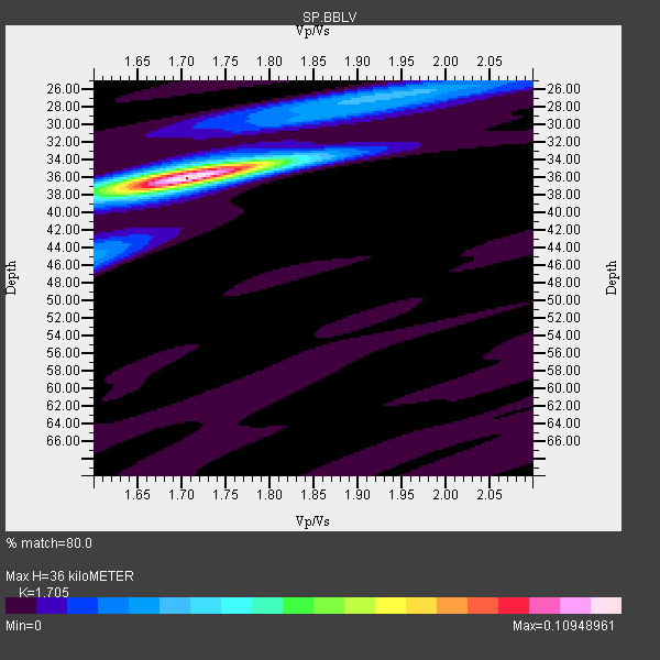
| Thickness Estimate: | 36 km |
| Thickness StdDev: | 0.2 km |
| Vp/Vs Estimate: | 1.71 |
| Vp/Vs StdDev: | 0.01 |
| Vs Estimate: | 3.85 km/s |
| Poisson's Ratio: | 0.24 |
| Peak Value: | 0.11 |
| Assumed Vp: | 6.565 km/s |
| Ps Weight: | 0.33333334 |
| PpPs Weight: | 0.33333334 |
| PsPs Weight: | 0.33333328 |
| Residual Complexity: | 0.348 |
| Nearby stations H: | +- |
| (2.0 deg) Vp/Vs: | +- |
11 with match > 90% ( 61.11111 %) and 18 with match > 80% ( 100.0 %) out of 18.
Download stack as xyz text file.
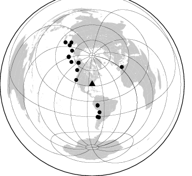
Azimuth Distribution of Events:
Prior Results for this Station
| Study | Thickness | Vp/Vs | Vp | Vs | Poissons Ratio | Extra |
| EARS | 36 km | 1.71 | 6.565 km/s | 3.85 km/s | 0.24 | |
| Crust2.0 | 31 km | 1.78 | 6.565 km/s | 3.684 km/s | 0.27 | DG,thin Platform 1 km seds. |
| Global Maxima | 36 km | 1.71 | 6.565 km/s | 3.85 km/s | 0.24 | amp=0.10948961 |
| Local Maxima 1 | 35 km | 1.70 | 6.565 km/s | 3.867 km/s | 0.23 | amp=0.02838748 |
| Local Maxima 2 | 27 km | 1.92 | 6.565 km/s | 3.41 km/s | 0.32 | amp=0.025626518 |
| Local Maxima 3 | 44 km | 1.61 | 6.565 km/s | 4.09 km/s | 0.18 | amp=0.02229926 |
| Local Maxima 4 | 28 km | 1.88 | 6.565 km/s | 3.483 km/s | 0.30 | amp=0.014094235 |
| Predicted Arrivals for vertical incidence (zero ray parameter) | |
| Ps | 3.87 SECOND |
| PpPs | 14.83 SECOND |
| PsPs/PpSs | 18.70 SECOND |
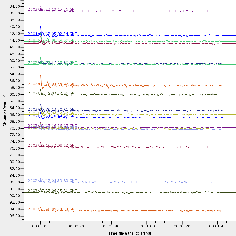
Events Processed for this Station
Download zip of receiver functions as SAC
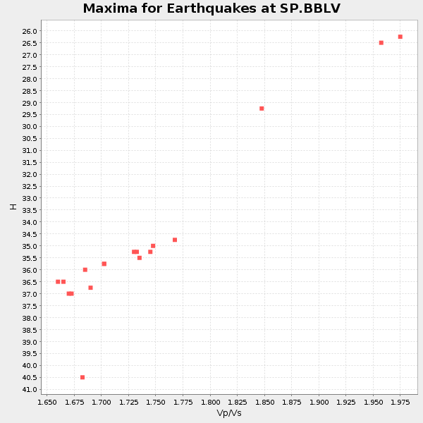
Plot maxima for each earthquake.
Events Used in the Stack
(18 events)| Radial Match | Distance | Baz | FERegion | Time | Lat/Lon | Depth | Magnitude |
| 98.59706 | 67.1 deg | 60.022 deg | Northern Algeria | 2003/05/21 18:44:20 GMT | (37.0, 3.6) | 12 km | 6.5 MB, 6.9 MS, 6.8 MW, 6.7 MW |
| 97.17618 | 64.9 deg | 170.578 deg | Near Coast Of Central Chile | 2003/06/20 13:30:41 GMT | (-30.6, -71.6) | 33 km | 6.4 MB, 6.8 MS, 6.8 MW, 6.7 MW |
| 96.80742 | 49.6 deg | 327.466 deg | Central Alaska | 2002/11/03 22:12:41 GMT | (63.5, -147.4) | 4.9 km | 7.0 MB, 8.5 MS, 7.9 MW |
| 96.03651 | 70.9 deg | 319.549 deg | Rat Islands, Aleutian Islands | 2003/06/23 12:12:34 GMT | (51.4, 176.8) | 20 km | 6.3 MB, 7.0 MS, 6.9 MW, 6.8 MW |
| 96.02481 | 42.3 deg | 165.472 deg | Western Brazil | 2003/06/20 06:19:38 GMT | (-7.6, -71.7) | 558 km | 6.4 MB, 7.1 MW, 7.0 MW |
| 95.9065 | 76.6 deg | 329.054 deg | Kamchatka Peninsula, Russia | 2003/06/16 22:08:02 GMT | (55.5, 160.0) | 175 km | 6.3 MB, 6.9 MW, 6.9 MW |
| 93.4922 | 56.7 deg | 165.269 deg | Chile-Bolivia Border Region | 2002/03/28 04:56:22 GMT | (-21.7, -68.3) | 125 km | 6.1 MB, 6.5 MW, 6.5 MW |
| 93.24159 | 43.0 deg | 165.706 deg | Western Brazil | 2002/10/12 20:09:11 GMT | (-8.3, -71.7) | 534 km | 6.5 MB, 6.9 MW, 6.9 MW |
| 91.349236 | 32.4 deg | 284.557 deg | Central California | 2003/12/22 19:15:56 GMT | (35.7, -121.1) | 7.6 km | 6.1 MB, 6.4 MS, 6.5 MW, 6.4 MW |
| 90.88175 | 97.3 deg | 327.458 deg | Near East Coast Of Honshu, Japan | 2003/05/26 09:24:33 GMT | (38.8, 141.6) | 68 km | 6.7 MB, 7.0 MW, 7.0 MW |
| 90.17406 | 40.4 deg | 313.319 deg | Queen Charlotte Islands Region | 2001/10/12 05:02:34 GMT | (52.6, -132.2) | 20 km | 5.6 MB, 5.8 MS, 6.2 MW, 6.1 MW |
| 89.674675 | 70.3 deg | 318.997 deg | Rat Islands, Aleutian Islands | 2003/03/17 16:36:17 GMT | (51.3, 178.0) | 33 km | 5.9 MB, 6.7 MS, 7.0 MW, 7.0 MW |
| 89.39512 | 66.1 deg | 168.492 deg | San Juan Province, Argentina | 2002/09/24 03:57:22 GMT | (-31.5, -69.2) | 120 km | 6.2 MB, 6.4 MW, 6.3 MW |
| 88.59343 | 49.8 deg | 327.443 deg | Central Alaska | 2002/10/23 11:27:19 GMT | (63.5, -147.9) | 4.2 km | 6.0 MB, 6.7 MS, 6.7 MW, 6.7 MW |
| 87.69495 | 88.1 deg | 330.063 deg | Northwest Of Kuril Islands | 2002/11/17 04:53:53 GMT | (47.8, 146.2) | 459 km | 7.3 MW, 7.3 MW |
| 86.72493 | 91.4 deg | 333.516 deg | Primor'ye, Russia | 2003/07/27 06:25:31 GMT | (47.2, 139.2) | 470 km | 6.3 MB, 6.8 MW, 6.8 MW |
| 86.33794 | 70.7 deg | 319.605 deg | Rat Islands, Aleutian Islands | 2003/06/15 19:24:33 GMT | (51.6, 176.9) | 20 km | 6.0 MB, 6.4 MS, 6.5 MW, 6.5 MW |
| 83.868 | 59.6 deg | 316.753 deg | Unimak Island Region, Alaska | 2003/02/19 03:32:36 GMT | (53.6, -164.6) | 19 km | 5.8 MB, 6.6 MS, 6.6 MW, 6.6 MW |
Losers
(0 events)| Radial Match | Distance | Baz | FERegion | Time | Lat/Lon | Depth | Magnitude | Reason |
