You are here: Home > Network List > SP - South Carolina Earth Physics Project Stations List
> Station BBLV Batesburg-Leesville High School, Lexington County, SC USA > Earthquake Result Viewer
BBLV Batesburg-Leesville High School, Lexington County, SC USA - Earthquake Result Viewer
| Earthquake location: |
Chile-Bolivia Border Region |
| Earthquake latitude/longitude: |
-21.7/-68.3 |
| Earthquake time(UTC): |
2002/03/28 (087) 04:56:22 GMT |
| Earthquake Depth: |
125 km |
| Earthquake Magnitude: |
6.1 MB, 6.5 MW, 6.5 MW |
| Earthquake Catalog/Contributor: |
WHDF/NEIC |
|
| Network: |
SP South Carolina Earth Physics Project |
| Station: |
BBLV Batesburg-Leesville High School, Lexington County, SC USA |
| Lat/Lon: |
33.92 N/81.53 W |
| Elevation: |
198 m |
|
| Distance: |
56.7 deg |
| Az: |
346.862 deg |
| Baz: |
165.269 deg |
| Ray Param: |
0.0635879 |
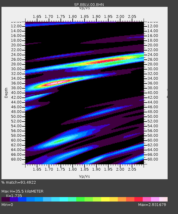
| Estimated Moho Depth: |
35.5 km |
| Estimated Crust Vp/Vs: |
1.74 |
| Assumed Crust Vp: |
6.565 km/s |
| Estimated Crust Vs: |
3.784 km/s |
| Estimated Crust Poisson's Ratio: |
0.25 |
|
| Radial Match: |
93.4922 % |
| Radial Bump: |
347 |
| Transverse Match: |
80.03432 % |
| Transverse Bump: |
400 |
| SOD ConfigId: |
2186 |
| Insert Time: |
2010-02-25 16:35:09.413 +0000 |
| GWidth: |
2.5 |
| Max Bumps: |
400 |
| Tol: |
0.001 |
|
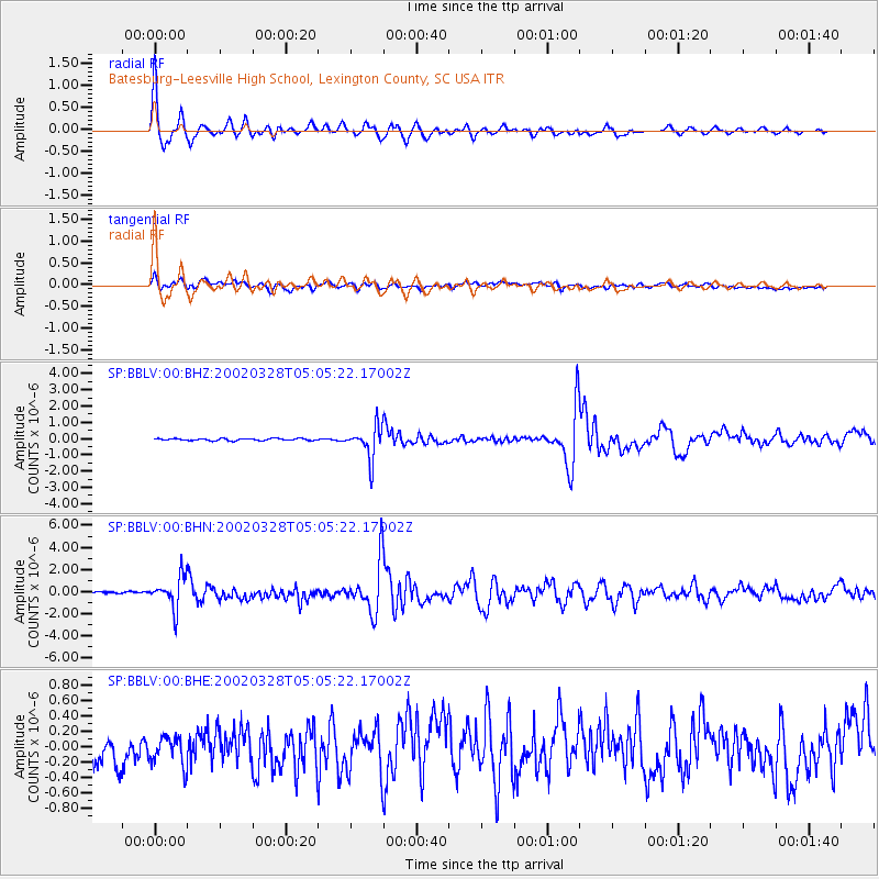
Signal To Noise
| Channel | StoN | STA | LTA |
| SP:BBLV:00:BHN:20020328T05:05:22.17002Z | 9.344031 | 1.4407412E-6 | 1.541884E-7 |
| SP:BBLV:00:BHE:20020328T05:05:22.17002Z | 1.1186842 | 2.0428311E-7 | 1.8261017E-7 |
| SP:BBLV:00:BHZ:20020328T05:05:22.17002Z | 15.676904 | 9.791931E-7 | 6.246088E-8 |
| Arrivals |
| Ps | 4.2 SECOND |
| PpPs | 14 SECOND |
| PsPs/PpSs | 18 SECOND |


