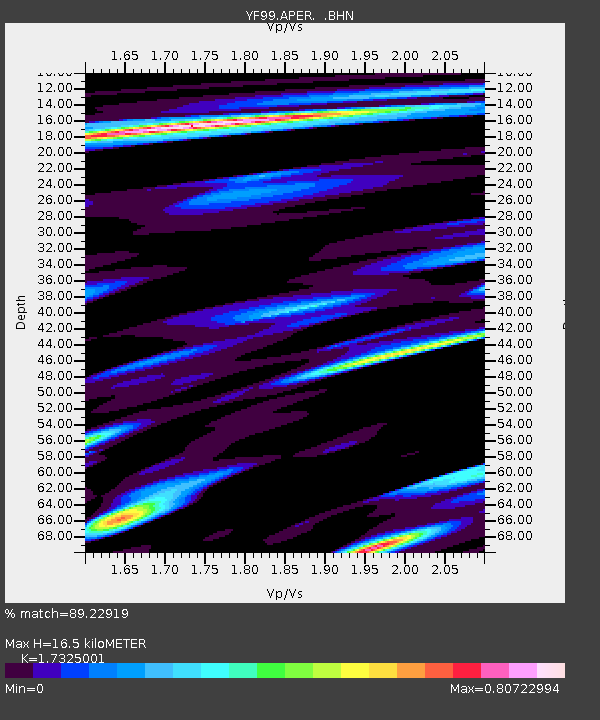
APER YF.APER - Earthquake Result Viewer

Earthquake location: Southwestern Ryukyu Isl., Japan
Earthquake latitude/longitude: 23.3/124.2
Earthquake time(UTC): 2000/11/08 (313) 18:36:21 GMT
Earthquake Depth: 14 km
Earthquake Magnitude: 5.7 MB, 5.5 MS, 5.8 MW, 5.6 MW
Earthquake Catalog/Contributor: WHDF/NEIC
Network: YF Midsea - Mantle Investigation of the Deep Suture between Eurasia and Africa
Station: APER YF.APER
Lat/Lon: 35.55 N/27.17 E
Elevation: 250 m
Distance: 82.2 deg
Az: 305.213 deg
Baz: 67.148 deg
Ray Param: 0.04706056
Estimated Moho Depth: 16.5 km
Estimated Crust Vp/Vs: 1.73
Assumed Crust Vp: 5.627 km/s
Estimated Crust Vs: 3.248 km/s
Estimated Crust Poisson's Ratio: 0.25
Radial Match: 89.22919 %
Radial Bump: 400
Transverse Match: 87.81952 %
Transverse Bump: 400
SOD ConfigId: 3753
Insert Time: 2010-03-08 22:34:44.478 +0000
GWidth: 2.5
Max Bumps: 400
Tol: 0.001

Signal To Noise

ChannelStoNSTALTA
YF:APER: :BHN:20001108T18:48:10.528003Z2.42104943.7168283E-71.5352137E-7
YF:APER: :BHE:20001108T18:48:10.528003Z5.4159167.040721E-71.3000056E-7
YF:APER: :BHZ:20001108T18:48:10.528003Z12.6771091.9897461E-61.5695583E-7
Arrivals
Ps2.2 SECOND
PpPs7.8 SECOND
PsPs/PpSs10 SECOND