
Station YF APER - YF.APER
Network: YF99 - Midsea - Mantle Investigation of the Deep Suture between Eurasia and Africa
Nearby stations (2 deg radius)
| Station | Name | (Lat, Lon) | Start / End | Elevation |
| APER | YF.APER | (35.55, 27.17) | 1999-11-03 / 2499-01-01 | 250 m |
| Crust2 Type: | S5,continental slope, margin, transition 8 km seds. |
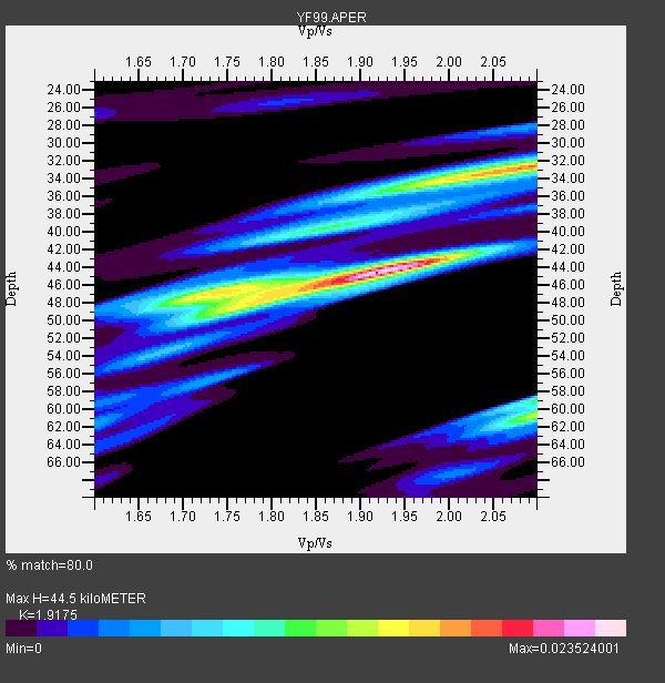
| Thickness Estimate: | 44 km |
| Thickness StdDev: | 5.9 km |
| Vp/Vs Estimate: | 1.92 |
| Vp/Vs StdDev: | 0.09 |
| Vs Estimate: | 2.934 km/s |
| Poisson's Ratio: | 0.31 |
| Peak Value: | 0.02 |
| Assumed Vp: | 5.627 km/s |
| Ps Weight: | 0.33333334 |
| PpPs Weight: | 0.33333334 |
| PsPs Weight: | 0.33333328 |
| Residual Complexity: | 0.754 |
| Nearby stations H: | +- |
| (2.0 deg) Vp/Vs: | +- |
4 with match > 90% ( 14.814815 %) and 27 with match > 80% ( 100.0 %) out of 27.
Download stack as xyz text file.
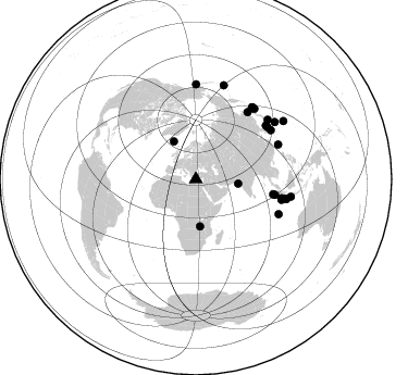
Azimuth Distribution of Events:
Prior Results for this Station
| Study | Thickness | Vp/Vs | Vp | Vs | Poissons Ratio | Extra |
| EARS | 44 km | 1.92 | 5.627 km/s | 2.934 km/s | 0.31 | |
| Crust2.0 | 28 km | 1.82 | 5.627 km/s | 3.087 km/s | 0.28 | S5,continental slope, margin, transition 8 km seds. |
| Global Maxima | 44 km | 1.92 | 5.627 km/s | 2.934 km/s | 0.31 | amp=0.023524001 |
| Local Maxima 1 | 32 km | 2.09 | 5.627 km/s | 2.689 km/s | 0.35 | amp=0.01771377 |
| Local Maxima 2 | 60 km | 2.10 | 5.627 km/s | 2.683 km/s | 0.35 | amp=0.014133117 |
| Local Maxima 3 | 48 km | 1.77 | 5.627 km/s | 3.174 km/s | 0.27 | amp=0.013353327 |
| Local Maxima 4 | 46 km | 1.74 | 5.627 km/s | 3.238 km/s | 0.25 | amp=0.012046638 |
| Predicted Arrivals for vertical incidence (zero ray parameter) | |
| Ps | 7.26 SECOND |
| PpPs | 23.07 SECOND |
| PsPs/PpSs | 30.33 SECOND |
Events Processed for this Station
Download zip of receiver functions as SAC
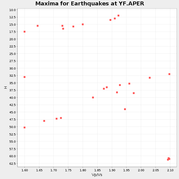
Plot maxima for each earthquake.
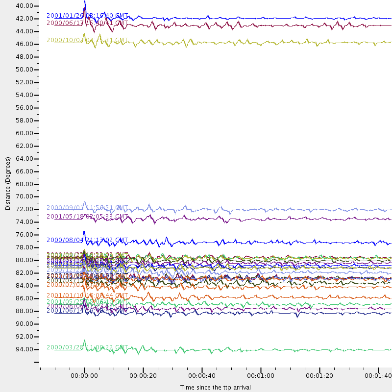
Events Used in the Stack
(27 events)| Radial Match | Distance | Baz | FERegion | Time | Lat/Lon | Depth | Magnitude |
| 94.902466 | 96.8 deg | 56.52 deg | Volcano Islands, Japan Region | 2000/03/28 11:00:22 GMT | (22.3, 143.7) | 126 km | 6.8 MB, 7.6 MS, 7.6 MW, 7.6 MW |
| 94.291794 | 80.9 deg | 102.376 deg | Southern Sumatra, Indonesia | 2001/02/13 19:28:30 GMT | (-4.7, 102.6) | 36 km | 6.2 MB, 7.2 MS, 7.4 MW, 7.0 ME |
| 91.07537 | 82.5 deg | 112.727 deg | South Indian Ocean | 2000/06/18 14:44:13 GMT | (-13.8, 97.5) | 10 km | 6.8 MB, 7.8 MS, 7.8 MW, 7.6 MW |
| 90.24009 | 84.3 deg | 38.128 deg | Kuril Islands | 2001/05/25 00:40:50 GMT | (44.3, 148.4) | 33 km | 6.1 MB, 6.7 MS, 6.7 MW, 6.6 MW |
| 89.81786 | 80.7 deg | 102.883 deg | Southern Sumatra, Indonesia | 2000/09/22 18:22:03 GMT | (-5.0, 102.1) | 33 km | 5.8 MB, 5.9 MS, 6.2 MW, 6.2 MW |
| 89.22919 | 82.2 deg | 67.148 deg | Southwestern Ryukyu Isl., Japan | 2000/11/08 18:36:21 GMT | (23.3, 124.2) | 14 km | 5.7 MB, 5.5 MS, 5.8 MW, 5.6 MW |
| 89.21405 | 80.8 deg | 103.432 deg | Southwest Of Sumatra, Indonesia | 2000/09/12 16:27:24 GMT | (-5.4, 101.8) | 33 km | 5.7 MB, 6.1 MS, 6.0 MW, 5.9 MW |
| 89.16296 | 81.3 deg | 52.566 deg | Western Honshu, Japan | 2000/10/06 04:30:19 GMT | (35.5, 133.1) | 10 km | 5.8 MB, 6.8 MS, 7.0 ME, 6.7 MW |
| 89.117874 | 39.1 deg | 96.028 deg | Southern India | 2001/01/26 03:16:40 GMT | (23.4, 70.2) | 16 km | 6.9 MB, 8.0 MS, 7.7 MW, 7.7 ME |
| 89.039444 | 87.7 deg | 0.21 deg | Kodiak Island Region, Alaska | 2001/01/10 16:02:44 GMT | (57.1, -153.2) | 33 km | 6.2 MB, 6.8 MS, 7.1 MW, 6.8 ML |
| 88.66356 | 84.4 deg | 39.799 deg | Kuril Islands | 2000/01/28 14:21:07 GMT | (43.0, 146.8) | 61 km | 6.7 MB, 6.6 MS, 6.8 MW, 6.8 ME |
| 88.58989 | 84.5 deg | 102.032 deg | Sunda Strait, Indonesia | 2000/10/25 09:32:23 GMT | (-6.5, 105.6) | 38 km | 6.3 MB, 6.6 MS, 6.8 MW, 6.7 ME |
| 86.85205 | 78.1 deg | 37.744 deg | Sakhalin, Russia | 2000/08/04 21:13:02 GMT | (48.8, 142.2) | 10 km | 6.3 MB, 7.1 MS, 6.8 MW, 6.7 MW |
| 86.840805 | 83.3 deg | 38.368 deg | Kuril Islands | 2000/12/22 10:13:01 GMT | (44.8, 147.2) | 140 km | 6.0 MB, 6.2 MW, 6.2 MW |
| 86.34121 | 40.4 deg | 329.767 deg | Iceland | 2000/06/17 15:40:41 GMT | (64.0, -20.5) | 10 km | 5.7 MB, 6.6 MS, 6.8 MW, 6.5 MW |
| 86.29092 | 72.5 deg | 101.07 deg | Off W Coast Of Northern Sumatra | 2000/09/01 11:56:51 GMT | (1.4, 96.6) | 33 km | 5.6 MB, 6.0 MS, 6.2 MW, 6.0 MW |
| 85.83772 | 84.4 deg | 38.123 deg | Kuril Islands | 2001/06/24 13:18:51 GMT | (44.2, 148.5) | 33 km | 5.8 MB, 5.7 MS, 6.0 MW |
| 84.34624 | 82.6 deg | 56.978 deg | Kyushu, Japan | 2000/06/25 06:34:42 GMT | (31.2, 131.2) | 10 km | 5.8 MB, 5.7 MS, 6.2 MW, 5.9 MW |
| 83.84802 | 89.7 deg | 54.206 deg | Bonin Islands, Japan Region | 2000/08/06 07:27:12 GMT | (28.9, 139.6) | 395 km | 6.3 MB, 7.3 MW, 7.3 MW |
| 83.60176 | 81.7 deg | 53.974 deg | Western Honshu, Japan | 2001/03/24 06:27:53 GMT | (34.1, 132.5) | 50 km | 6.4 MB, 6.5 MS, 6.8 MW, 6.4 ME |
| 83.3659 | 88.9 deg | 100.415 deg | Java, Indonesia | 2001/05/25 05:06:10 GMT | (-7.9, 110.2) | 143 km | 5.8 MB, 6.3 MW, 6.3 MW |
| 82.41474 | 84.3 deg | 38.664 deg | Kuril Islands | 2001/01/03 14:47:49 GMT | (43.9, 147.8) | 33 km | 5.9 MB, 5.2 MS, 5.9 MW, 5.9 MW |
| 81.949905 | 90.4 deg | 16.613 deg | Andreanof Islands, Aleutian Is. | 2001/06/14 19:48:47 GMT | (51.2, -179.8) | 18 km | 6.0 MB, 6.3 MS, 6.5 MW, 6.1 ML |
| 80.93919 | 85.2 deg | 102.269 deg | Java, Indonesia | 2001/03/12 23:35:08 GMT | (-7.2, 106.1) | 33 km | 5.5 MB, 5.6 MS, 5.8 MW, 5.7 MW |
| 80.77448 | 85.9 deg | 50.398 deg | Near S. Coast Of Honshu, Japan | 2000/07/01 07:01:55 GMT | (34.2, 139.1) | 10 km | 6.0 MB, 6.1 MS, 6.2 MW, 6.2 MW |
| 80.469795 | 74.0 deg | 101.173 deg | Northern Sumatra, Indonesia | 2001/05/18 02:05:33 GMT | (0.4, 97.8) | 33 km | 5.4 MB, 5.8 MS, 5.9 MW, 5.9 MW |
| 80.01802 | 43.4 deg | 174.903 deg | Lake Tanganyika Region | 2000/10/02 02:25:31 GMT | (-8.0, 30.7) | 34 km | 6.1 MB, 6.7 MS, 6.5 MW, 6.2 ME |
Losers
(0 events)| Radial Match | Distance | Baz | FERegion | Time | Lat/Lon | Depth | Magnitude | Reason |
