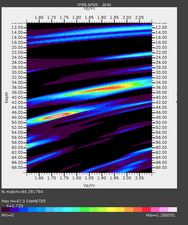
APER YF.APER - Earthquake Result Viewer
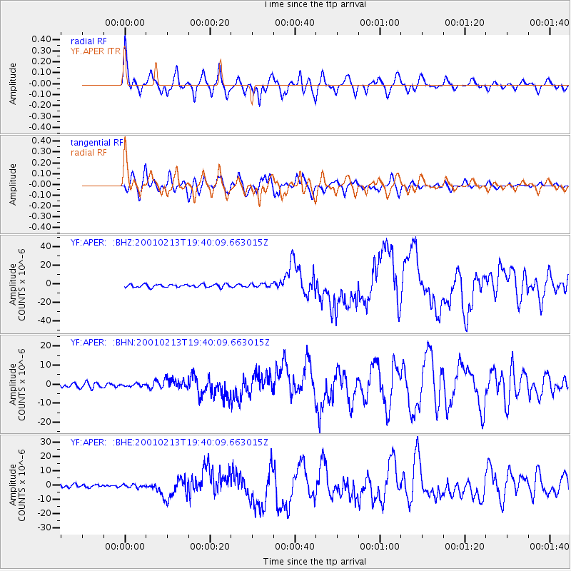
Earthquake location: Southern Sumatra, Indonesia
Earthquake latitude/longitude: -4.7/102.6
Earthquake time(UTC): 2001/02/13 (044) 19:28:30 GMT
Earthquake Depth: 36 km
Earthquake Magnitude: 6.2 MB, 7.2 MS, 7.4 MW, 7.0 ME
Earthquake Catalog/Contributor: WHDF/NEIC
Network: YF Midsea - Mantle Investigation of the Deep Suture between Eurasia and Africa
Station: APER YF.APER
Lat/Lon: 35.55 N/27.17 E
Elevation: 250 m
Distance: 80.9 deg
Az: 306.953 deg
Baz: 102.376 deg
Ray Param: 0.04791098
Estimated Moho Depth: 47.0 km
Estimated Crust Vp/Vs: 1.73
Assumed Crust Vp: 5.627 km/s
Estimated Crust Vs: 3.262 km/s
Estimated Crust Poisson's Ratio: 0.25
Radial Match: 94.291794 %
Radial Bump: 400
Transverse Match: 91.71241 %
Transverse Bump: 400
SOD ConfigId: 3744
Insert Time: 2010-03-08 22:35:24.461 +0000
GWidth: 2.5
Max Bumps: 400
Tol: 0.001

Signal To Noise

ChannelStoNSTALTA
YF:APER: :BHN:20010213T19:40:09.663015Z0.562911876.684145E-71.187423E-6
YF:APER: :BHE:20010213T19:40:09.663015Z1.02670161.0467943E-61.0195702E-6
YF:APER: :BHZ:20010213T19:40:09.663015Z1.16287921.8356615E-61.5785486E-6
Arrivals
Ps6.2 SECOND
PpPs22 SECOND
PsPs/PpSs28 SECOND