You are here: Home > Network List > YF99 - Midsea - Mantle Investigation of the Deep Suture between Eurasia and Africa Stations List
> Station APER YF.APER > Earthquake Result Viewer
APER YF.APER - Earthquake Result Viewer
| Earthquake location: |
Kuril Islands |
| Earthquake latitude/longitude: |
44.2/148.5 |
| Earthquake time(UTC): |
2001/06/24 (175) 13:18:51 GMT |
| Earthquake Depth: |
33 km |
| Earthquake Magnitude: |
5.8 MB, 5.7 MS, 6.0 MW |
| Earthquake Catalog/Contributor: |
WHDF/NEIC |
|
| Network: |
YF Midsea - Mantle Investigation of the Deep Suture between Eurasia and Africa |
| Station: |
APER YF.APER |
| Lat/Lon: |
35.55 N/27.17 E |
| Elevation: |
250 m |
|
| Distance: |
84.4 deg |
| Az: |
315.589 deg |
| Baz: |
38.123 deg |
| Ray Param: |
0.045442224 |
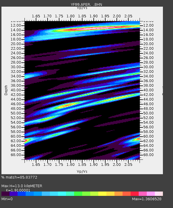
| Estimated Moho Depth: |
13.0 km |
| Estimated Crust Vp/Vs: |
1.91 |
| Assumed Crust Vp: |
5.627 km/s |
| Estimated Crust Vs: |
2.946 km/s |
| Estimated Crust Poisson's Ratio: |
0.31 |
|
| Radial Match: |
85.83772 % |
| Radial Bump: |
400 |
| Transverse Match: |
82.9331 % |
| Transverse Bump: |
400 |
| SOD ConfigId: |
4714 |
| Insert Time: |
2010-03-08 22:35:32.648 +0000 |
| GWidth: |
2.5 |
| Max Bumps: |
400 |
| Tol: |
0.001 |
|

Signal To Noise
| Channel | StoN | STA | LTA |
| YF:APER: :BHN:20010624T13:30:49.728005Z | 5.202799 | 2.9257258E-6 | 5.6233694E-7 |
| YF:APER: :BHE:20010624T13:30:49.728005Z | 5.3169975 | 2.5916463E-6 | 4.8742663E-7 |
| YF:APER: :BHZ:20010624T13:30:49.728005Z | 16.861784 | 6.204164E-6 | 3.679423E-7 |
| Arrivals |
| Ps | 2.1 SECOND |
| PpPs | 6.6 SECOND |
| PsPs/PpSs | 8.7 SECOND |


