You are here: Home > Network List > SP - South Carolina Earth Physics Project Stations List
> Station BBLV Batesburg-Leesville High School, Lexington County, SC USA > Earthquake Result Viewer
BBLV Batesburg-Leesville High School, Lexington County, SC USA - Earthquake Result Viewer
| Earthquake location: |
Northwest Of Kuril Islands |
| Earthquake latitude/longitude: |
47.8/146.2 |
| Earthquake time(UTC): |
2002/11/17 (321) 04:53:53 GMT |
| Earthquake Depth: |
459 km |
| Earthquake Magnitude: |
7.3 MW, 7.3 MW |
| Earthquake Catalog/Contributor: |
WHDF/NEIC |
|
| Network: |
SP South Carolina Earth Physics Project |
| Station: |
BBLV Batesburg-Leesville High School, Lexington County, SC USA |
| Lat/Lon: |
33.92 N/81.53 W |
| Elevation: |
198 m |
|
| Distance: |
88.1 deg |
| Az: |
38.009 deg |
| Baz: |
330.063 deg |
| Ray Param: |
0.04172436 |
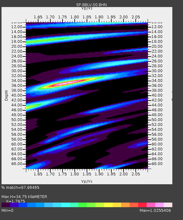
| Estimated Moho Depth: |
34.75 km |
| Estimated Crust Vp/Vs: |
1.77 |
| Assumed Crust Vp: |
6.565 km/s |
| Estimated Crust Vs: |
3.714 km/s |
| Estimated Crust Poisson's Ratio: |
0.26 |
|
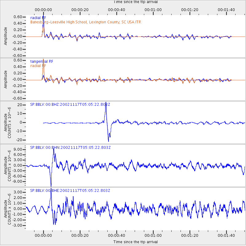
| Radial Match: |
87.69495 % |
| Radial Bump: |
365 |
| Transverse Match: |
80.05699 % |
| Transverse Bump: |
400 |
| SOD ConfigId: |
2186 |
| Insert Time: |
2010-02-25 16:35:20.482 +0000 |
| GWidth: |
2.5 |
| Max Bumps: |
400 |
| Tol: |
0.001 |
|
Signal To Noise
| Channel | StoN | STA | LTA |
| SP:BBLV:00:BHN:20021117T05:05:22.803Z | 10.249515 | 3.481796E-6 | 3.3970352E-7 |
| SP:BBLV:00:BHE:20021117T05:05:22.803Z | 5.542536 | 1.1713049E-6 | 2.1133016E-7 |
| SP:BBLV:00:BHZ:20021117T05:05:22.803Z | 25.914982 | 7.1337827E-6 | 2.752764E-7 |
| Arrivals |
| Ps | 4.2 SECOND |
| PpPs | 14 SECOND |
| PsPs/PpSs | 18 SECOND |


