You are here: Home > Network List > XC06 - High Lava Plains Broadband Seismic Experiment Stations List
> Station OR002 OR002 > Earthquake Result Viewer
OR002 OR002 - Earthquake Result Viewer
| Earthquake location: |
South Of Mariana Islands |
| Earthquake latitude/longitude: |
12.5/143.2 |
| Earthquake time(UTC): |
2008/05/09 (130) 21:51:29 GMT |
| Earthquake Depth: |
76 km |
| Earthquake Magnitude: |
6.1 MB, 6.7 MW, 6.7 MW |
| Earthquake Catalog/Contributor: |
WHDF/NEIC |
|
| Network: |
XC High Lava Plains Broadband Seismic Experiment |
| Station: |
OR002 OR002 |
| Lat/Lon: |
45.02 N/117.87 W |
| Elevation: |
1019 m |
|
| Distance: |
87.5 deg |
| Az: |
44.529 deg |
| Baz: |
285.071 deg |
| Ray Param: |
0.04315501 |
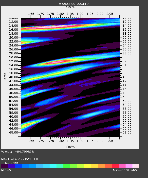
| Estimated Moho Depth: |
14.25 km |
| Estimated Crust Vp/Vs: |
1.75 |
| Assumed Crust Vp: |
6.571 km/s |
| Estimated Crust Vs: |
3.744 km/s |
| Estimated Crust Poisson's Ratio: |
0.26 |
|
| Radial Match: |
94.799515 % |
| Radial Bump: |
389 |
| Transverse Match: |
84.29686 % |
| Transverse Bump: |
400 |
| SOD ConfigId: |
2504 |
| Insert Time: |
2010-02-26 14:56:58.593 +0000 |
| GWidth: |
2.5 |
| Max Bumps: |
400 |
| Tol: |
0.001 |
|
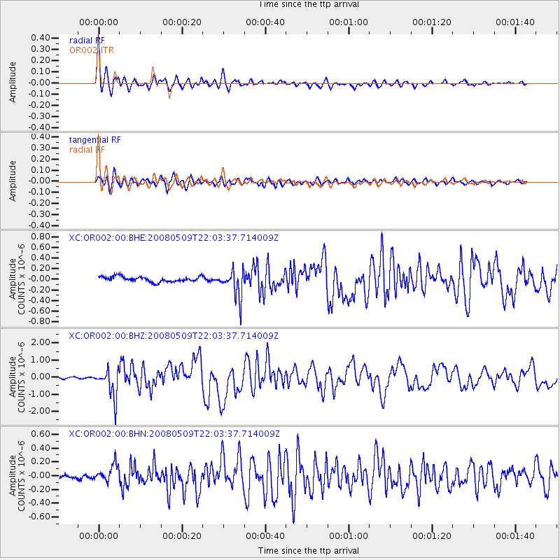
Signal To Noise
| Channel | StoN | STA | LTA |
| XC:OR002:00:BHZ:20080509T22:03:37.714009Z | 14.956662 | 8.49028E-7 | 5.6765874E-8 |
| XC:OR002:00:BHN:20080509T22:03:37.714009Z | 3.0383887 | 1.2808478E-7 | 4.215549E-8 |
| XC:OR002:00:BHE:20080509T22:03:37.714009Z | 5.4891286 | 2.611083E-7 | 4.7568264E-8 |
| Arrivals |
| Ps | 1.7 SECOND |
| PpPs | 5.8 SECOND |
| PsPs/PpSs | 7.5 SECOND |


