
Station XC OR002 - OR002
Network: XC06 - High Lava Plains Broadband Seismic Experiment
Nearby stations (2 deg radius)
| Station | Name | (Lat, Lon) | Start / End | Elevation |
| OR002 | OR002 | (45.02, -117.87) | 2006-06-23 / 2011-01-01 | 1019 m |
| Crust2 Type: | Q9,orogen/41km no ice, cordilleras, 0.25 km seds. |
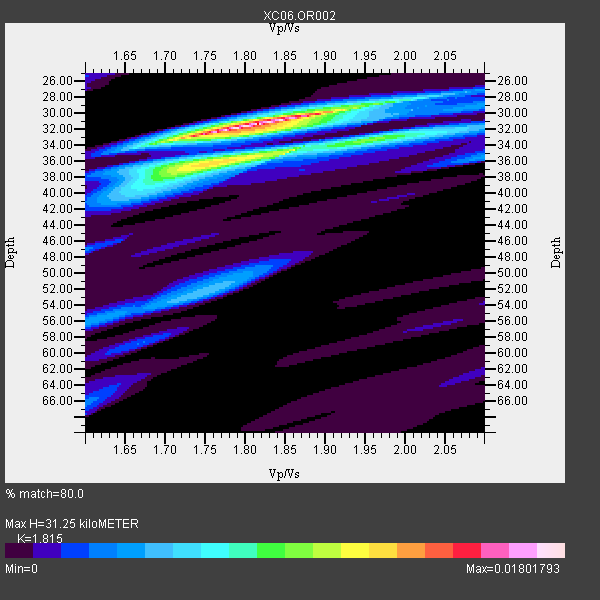
| Thickness Estimate: | 31 km |
| Thickness StdDev: | 5.3 km |
| Vp/Vs Estimate: | 1.82 |
| Vp/Vs StdDev: | 0.06 |
| Vs Estimate: | 3.62 km/s |
| Poisson's Ratio: | 0.28 |
| Peak Value: | 0.02 |
| Assumed Vp: | 6.571 km/s |
| Ps Weight: | 0.33333334 |
| PpPs Weight: | 0.33333334 |
| PsPs Weight: | 0.33333328 |
| Residual Complexity: | 0.615 |
| Nearby stations H: | +- |
| (2.0 deg) Vp/Vs: | +- |
4 with match > 90% ( 80.0 %) and 4 with match > 80% ( 80.0 %) out of 5.
Download stack as xyz text file.
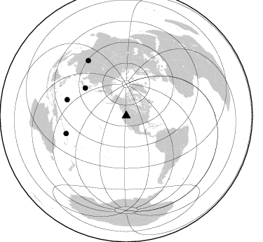
Azimuth Distribution of Events:
Prior Results for this Station
| Study | Thickness | Vp/Vs | Vp | Vs | Poissons Ratio | Extra |
| EARS | 31 km | 1.82 | 6.571 km/s | 3.62 km/s | 0.28 | |
| Crust2.0 | 41 km | 1.76 | 6.571 km/s | 3.735 km/s | 0.26 | Q9,orogen/41km no ice, cordilleras, 0.25 km seds. |
| Global Maxima | 31 km | 1.82 | 6.571 km/s | 3.62 km/s | 0.28 | amp=0.01801793 |
| Local Maxima 1 | 34 km | 1.86 | 6.571 km/s | 3.533 km/s | 0.30 | amp=0.011211777 |
| Local Maxima 2 | 38 km | 1.70 | 6.571 km/s | 3.871 km/s | 0.23 | amp=0.005867833 |
| Local Maxima 3 | 52 km | 1.74 | 6.571 km/s | 3.771 km/s | 0.25 | amp=0.0052523986 |
| Local Maxima 4 | 36 km | 2.10 | 6.571 km/s | 3.136 km/s | 0.35 | amp=0.0040341066 |
| Predicted Arrivals for vertical incidence (zero ray parameter) | |
| Ps | 3.88 SECOND |
| PpPs | 13.39 SECOND |
| PsPs/PpSs | 17.26 SECOND |
Events Processed for this Station
Download zip of receiver functions as SAC
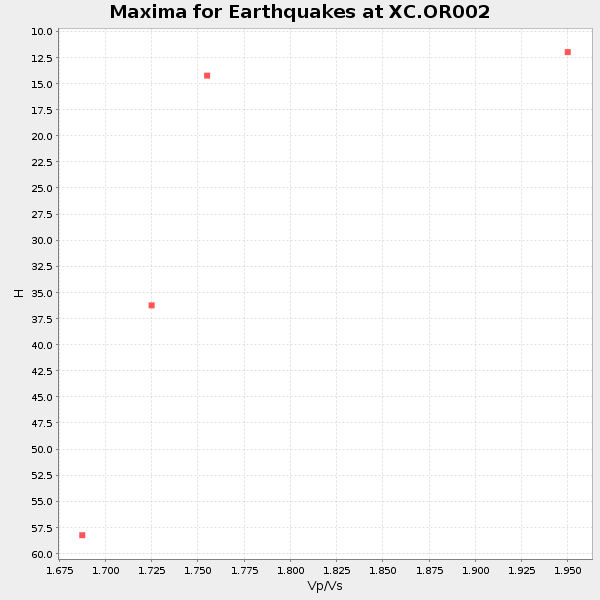
Plot maxima for each earthquake.
Events Used in the Stack
(4 events)| Radial Match | Distance | Baz | FERegion | Time | Lat/Lon | Depth | Magnitude |
| 97.37916 | 89.1 deg | 253.548 deg | Santa Cruz Islands Region | 2008/07/19 09:27:01 GMT | (-11.0, 164.5) | 11 km | 6.1 MB, 6.4 MS, 6.6 MW, 6.6 MW |
| 95.30572 | 70.7 deg | 303.939 deg | Off East Coast Of Honshu, Japan | 2008/07/19 02:39:28 GMT | (37.6, 142.2) | 22 km | 6.2 MB, 7.0 MS, 7.0 MW, 6.9 MW |
| 94.92415 | 95.6 deg | 325.373 deg | Sichuan, China | 2008/05/12 06:28:01 GMT | (31.0, 103.3) | 19 km | 6.9 MB, 8.1 MS, 7.9 MW, 7.9 MW |
| 94.799515 | 87.5 deg | 285.071 deg | South Of Mariana Islands | 2008/05/09 21:51:29 GMT | (12.5, 143.2) | 76 km | 6.1 MB, 6.7 MW, 6.7 MW |
Losers
(1 events)| Radial Match | Distance | Baz | FERegion | Time | Lat/Lon | Depth | Magnitude | Reason |
| 74.192215 | 93.8 deg | 27.303 deg | Dodecanese Islands, Greece | 2008/07/15 03:26:34 GMT | (35.8, 27.9) | 52 km | 6.5 MB, 6.4 MW, 6.4 MW |
