You are here: Home > Network List > YF99 - Midsea - Mantle Investigation of the Deep Suture between Eurasia and Africa Stations List
> Station GHAR YF.GHAR > Earthquake Result Viewer
GHAR YF.GHAR - Earthquake Result Viewer
| Earthquake location: |
Near Coast Of Peru |
| Earthquake latitude/longitude: |
-16.1/-74.0 |
| Earthquake time(UTC): |
2001/07/05 (186) 13:53:48 GMT |
| Earthquake Depth: |
62 km |
| Earthquake Magnitude: |
6.2 MB, 6.6 MW, 6.5 ME |
| Earthquake Catalog/Contributor: |
WHDF/NEIC |
|
| Network: |
YF Midsea - Mantle Investigation of the Deep Suture between Eurasia and Africa |
| Station: |
GHAR YF.GHAR |
| Lat/Lon: |
32.12 N/13.09 E |
| Elevation: |
650 m |
|
| Distance: |
96.0 deg |
| Az: |
58.434 deg |
| Baz: |
254.869 deg |
| Ray Param: |
0.040601335 |
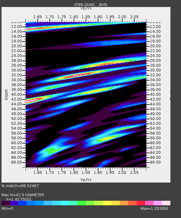
| Estimated Moho Depth: |
42.5 km |
| Estimated Crust Vp/Vs: |
1.62 |
| Assumed Crust Vp: |
6.159 km/s |
| Estimated Crust Vs: |
3.808 km/s |
| Estimated Crust Poisson's Ratio: |
0.19 |
|
| Radial Match: |
89.52467 % |
| Radial Bump: |
400 |
| Transverse Match: |
82.8368 % |
| Transverse Bump: |
400 |
| SOD ConfigId: |
16820 |
| Insert Time: |
2010-03-08 22:37:07.088 +0000 |
| GWidth: |
2.5 |
| Max Bumps: |
400 |
| Tol: |
0.001 |
|

Signal To Noise
| Channel | StoN | STA | LTA |
| YF:GHAR: :BHN:20010705T14:06:37.214004Z | 0.9132386 | 1.0564857E-7 | 1.1568562E-7 |
| YF:GHAR: :BHE:20010705T14:06:37.214004Z | 1.2746624 | 1.3727706E-7 | 1.076968E-7 |
| YF:GHAR: :BHZ:20010705T14:06:37.214004Z | 2.9711094 | 3.883206E-7 | 1.3069885E-7 |
| Arrivals |
| Ps | 4.3 SECOND |
| PpPs | 18 SECOND |
| PsPs/PpSs | 22 SECOND |


