
Station YF GHAR - YF.GHAR
Network: YF99 - Midsea - Mantle Investigation of the Deep Suture between Eurasia and Africa
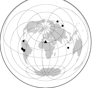
Nearby stations (2 deg radius)
| Station | Name | (Lat, Lon) | Start / End | Elevation |
| GHAR | YF.GHAR | (32.12, 13.09) | 2000-01-19 / 2001-12-31 | 0.6 km |
| Crust2 Type: | T5,Margin /shield transition, 5 km seds. |
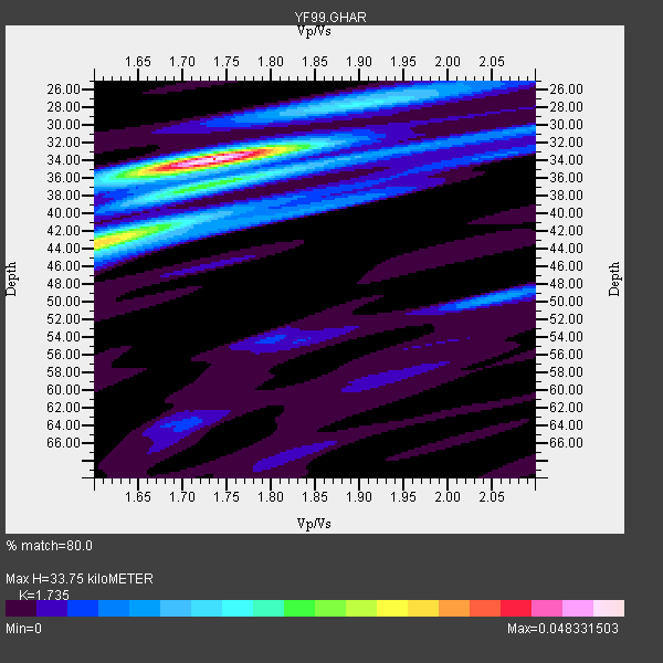
| Thickness Estimate: | 34 km |
| Thickness StdDev: | 1.7 km |
| Vp/Vs Estimate: | 1.74 |
| Vp/Vs StdDev: | 0.03 |
| Vs Estimate: | 3.55 km/s |
| Poisson's Ratio: | 0.25 |
| Peak Value: | 0.05 |
| Assumed Vp: | 6.159 km/s |
| Ps Weight: | 0.33333334 |
| PpPs Weight: | 0.33333334 |
| PsPs Weight: | 0.33333328 |
| Residual Complexity: | 0.582 |
| Nearby stations H: | 38 km +- 5.7 km |
| (2.0 deg) Vp/Vs: | 1.70 +- 0.06 |
4 with match > 90% ( 40.0 %) and 10 with match > 80% ( 100.0 %) out of 10.
Download stack as xyz text file.
Azimuth Distribution of Events:
Prior Results for this Station
| Study | Thickness | Vp/Vs | Vp | Vs | Poissons Ratio | Extra |
| EARS | 34 km | 1.74 | 6.159 km/s | 3.55 km/s | 0.25 | |
| Crust2.0 | 32 km | 1.79 | 6.159 km/s | 3.434 km/s | 0.27 | T5,Margin /shield transition, 5 km seds. |
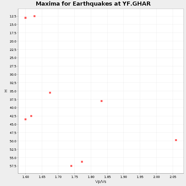
| Global Maxima | 34 km | 1.74 | 6.159 km/s | 3.55 km/s | 0.25 | amp=0.048331503 |
| Local Maxima 1 | 43 km | 1.61 | 6.159 km/s | 3.838 km/s | 0.18 | amp=0.031861488 |
| Local Maxima 2 | 36 km | 1.78 | 6.159 km/s | 3.46 km/s | 0.27 | amp=0.016480267 |
| Local Maxima 3 | 50 km | 2.06 | 6.159 km/s | 2.997 km/s | 0.34 | amp=0.011439005 |
| Local Maxima 4 | 27 km | 1.91 | 6.159 km/s | 3.225 km/s | 0.31 | amp=0.01045918 |
| Predicted Arrivals for vertical incidence (zero ray parameter) | |
| Ps | 4.03 SECOND |
| PpPs | 14.99 SECOND |
| PsPs/PpSs | 19.01 SECOND |
Events Processed for this Station
Download zip of receiver functions as SAC
Plot maxima for each earthquake.
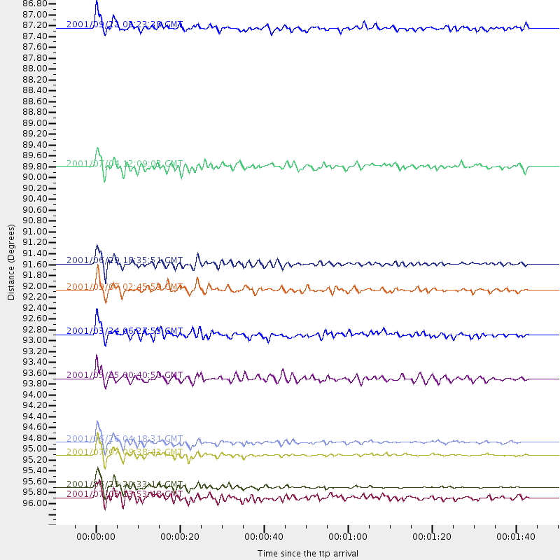
Events Used in the Stack
(10 events)| Radial Match | Distance | Baz | FERegion | Time | Lat/Lon | Depth | Magnitude |
| 98.1559 | 95.8 deg | 254.542 deg | Near Coast Of Peru | 2001/06/23 20:33:14 GMT | (-16.3, -73.6) | 33 km | 6.7 MB, 8.2 MS, 8.4 MW, 7.8 ME |
| 97.92817 | 95.2 deg | 252.664 deg | Near Coast Of Peru | 2001/07/07 09:38:43 GMT | (-17.5, -72.1) | 33 km | 6.6 MB, 7.3 MS, 7.6 MW, 7.5 ME |
| 95.929474 | 94.9 deg | 252.276 deg | Near Coast Of Peru | 2001/06/26 04:18:31 GMT | (-17.7, -71.6) | 24 km | 6.2 MB, 6.7 MS, 6.8 MW, 6.7 ME |
| 91.773506 | 92.9 deg | 46.365 deg | Western Honshu, Japan | 2001/03/24 06:27:53 GMT | (34.1, 132.5) | 50 km | 6.4 MB, 6.5 MS, 6.8 MW, 6.4 ME |
| 89.52467 | 96.0 deg | 254.869 deg | Near Coast Of Peru | 2001/07/05 13:53:48 GMT | (-16.1, -74.0) | 62 km | 6.2 MB, 6.6 MW, 6.5 ME |
| 88.96374 | 92.1 deg | 104.135 deg | South Indian Ocean | 2001/09/07 02:45:59 GMT | (-13.2, 97.3) | 10 km | 6.2 MB, 5.8 MS, 6.0 MW, 5.9 MW |
| 88.32639 | 91.6 deg | 248.018 deg | Southern Bolivia | 2001/06/29 18:35:51 GMT | (-19.5, -66.3) | 274 km | 5.7 MB, 6.1 MW, 6.1 MW |
| 83.36053 | 93.7 deg | 30.423 deg | Kuril Islands | 2001/05/25 00:40:50 GMT | (44.3, 148.4) | 33 km | 6.1 MB, 6.7 MS, 6.7 MW, 6.6 MW |
| 80.69812 | 89.8 deg | 249.821 deg | Central Bolivia | 2001/07/04 12:09:03 GMT | (-17.0, -65.7) | 33 km | 5.6 MB, 5.9 MS, 6.1 MW, 6.1 MW |
| 80.33298 | 87.2 deg | 272.768 deg | Colombia | 2001/09/22 03:23:38 GMT | (3.9, -76.0) | 179 km | 6.0 MB, 6.0 MW, 6.0 MW |
Losers
(0 events)| Radial Match | Distance | Baz | FERegion | Time | Lat/Lon | Depth | Magnitude | Reason |
