You are here: Home > Network List > YF99 - Midsea - Mantle Investigation of the Deep Suture between Eurasia and Africa Stations List
> Station GHAR YF.GHAR > Earthquake Result Viewer
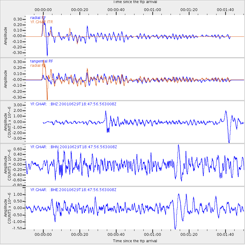
GHAR YF.GHAR - Earthquake Result Viewer

| Earthquake location: |
Southern Bolivia |
| Earthquake latitude/longitude: |
-19.5/-66.3 |
| Earthquake time(UTC): |
2001/06/29 (180) 18:35:51 GMT |
| Earthquake Depth: |
274 km |
| Earthquake Magnitude: |
5.7 MB, 6.1 MW, 6.1 MW |
| Earthquake Catalog/Contributor: |
WHDF/NEIC |
|
| Network: |
YF Midsea - Mantle Investigation of the Deep Suture between Eurasia and Africa |
| Station: |
GHAR YF.GHAR |
| Lat/Lon: |
32.12 N/13.09 E |
| Elevation: |
650 m |
|
| Distance: |
91.6 deg |
| Az: |
56.533 deg |
| Baz: |
248.018 deg |
| Ray Param: |
0.041452147 |
| Estimated Moho Depth: |
49.75 km |
| Estimated Crust Vp/Vs: |
2.06 |
| Assumed Crust Vp: |
6.159 km/s |
| Estimated Crust Vs: |
2.99 km/s |
| Estimated Crust Poisson's Ratio: |
0.35 |
|
| Radial Match: |
88.32639 % |
| Radial Bump: |
400 |
| Transverse Match: |
66.465996 % |
| Transverse Bump: |
400 |
| SOD ConfigId: |
16820 |
| Insert Time: |
2010-03-08 22:37:10.377 +0000 |
| GWidth: |
2.5 |
| Max Bumps: |
400 |
| Tol: |
0.001 |
|
Signal To Noise
| Channel | StoN | STA | LTA |
| YF:GHAR: :BHN:20010629T18:47:56.563008Z | 1.0676134 | 1.3906856E-7 | 1.3026117E-7 |
| YF:GHAR: :BHE:20010629T18:47:56.563008Z | 1.5995219 | 2.179978E-7 | 1.3628934E-7 |
| YF:GHAR: :BHZ:20010629T18:47:56.563008Z | 3.7602892 | 5.972099E-7 | 1.588202E-7 |
| Arrivals |
| Ps | 8.7 SECOND |
| PpPs | 24 SECOND |
| PsPs/PpSs | 33 SECOND |


