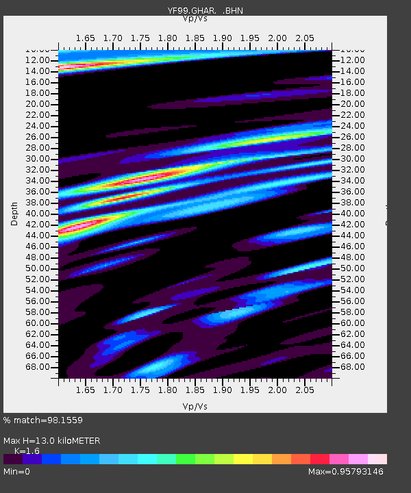
GHAR YF.GHAR - Earthquake Result Viewer

Earthquake location: Near Coast Of Peru
Earthquake latitude/longitude: -16.3/-73.6
Earthquake time(UTC): 2001/06/23 (174) 20:33:14 GMT
Earthquake Depth: 33 km
Earthquake Magnitude: 6.7 MB, 8.2 MS, 8.4 MW, 7.8 ME
Earthquake Catalog/Contributor: WHDF/NEIC
Network: YF Midsea - Mantle Investigation of the Deep Suture between Eurasia and Africa
Station: GHAR YF.GHAR
Lat/Lon: 32.12 N/13.09 E
Elevation: 650 m
Distance: 95.8 deg
Az: 58.372 deg
Baz: 254.542 deg
Ray Param: 0.04067571
Estimated Moho Depth: 13.0 km
Estimated Crust Vp/Vs: 1.60
Assumed Crust Vp: 6.159 km/s
Estimated Crust Vs: 3.85 km/s
Estimated Crust Poisson's Ratio: 0.18
Radial Match: 98.1559 %
Radial Bump: 399
Transverse Match: 86.739426 %
Transverse Bump: 400
SOD ConfigId: 16820
Insert Time: 2010-03-08 22:37:12.889 +0000
GWidth: 2.5
Max Bumps: 400
Tol: 0.001

Signal To Noise

ChannelStoNSTALTA
YF:GHAR: :BHN:20010623T20:46:05.512019Z1.19295381.2019248E-71.0075201E-7
YF:GHAR: :BHE:20010623T20:46:05.512019Z1.57457752.5324826E-71.6083568E-7
YF:GHAR: :BHZ:20010623T20:46:05.512019Z3.8435541.2500417E-63.2523067E-7
Arrivals
Ps1.3 SECOND
PpPs5.4 SECOND
PsPs/PpSs6.7 SECOND