You are here: Home > Network List > YF99 - Midsea - Mantle Investigation of the Deep Suture between Eurasia and Africa Stations List
> Station HVAR YF.HVAR > Earthquake Result Viewer
HVAR YF.HVAR - Earthquake Result Viewer
| Earthquake location: |
Sea Of Okhotsk |
| Earthquake latitude/longitude: |
46.8/145.4 |
| Earthquake time(UTC): |
2000/07/10 (192) 09:58:18 GMT |
| Earthquake Depth: |
360 km |
| Earthquake Magnitude: |
6.1 MB, 5.9 MW, 5.8 MW |
| Earthquake Catalog/Contributor: |
WHDF/NEIC |
|
| Network: |
YF Midsea - Mantle Investigation of the Deep Suture between Eurasia and Africa |
| Station: |
HVAR YF.HVAR |
| Lat/Lon: |
43.18 N/6.45 E |
| Elevation: |
250 m |
|
| Distance: |
83.3 deg |
| Az: |
331.086 deg |
| Baz: |
26.989 deg |
| Ray Param: |
0.04533877 |
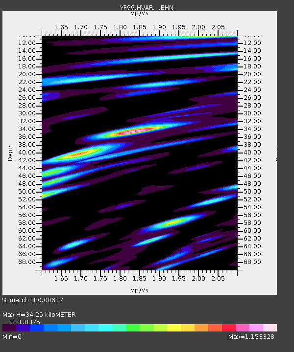
| Estimated Moho Depth: |
34.25 km |
| Estimated Crust Vp/Vs: |
1.84 |
| Assumed Crust Vp: |
5.405 km/s |
| Estimated Crust Vs: |
2.941 km/s |
| Estimated Crust Poisson's Ratio: |
0.29 |
|
| Radial Match: |
80.00617 % |
| Radial Bump: |
400 |
| Transverse Match: |
80.474525 % |
| Transverse Bump: |
400 |
| SOD ConfigId: |
16820 |
| Insert Time: |
2010-03-08 22:37:36.008 +0000 |
| GWidth: |
2.5 |
| Max Bumps: |
400 |
| Tol: |
0.001 |
|

Signal To Noise
| Channel | StoN | STA | LTA |
| YF:HVAR: :BHN:20000710T10:09:16.224009Z | 0.63351345 | 3.988234E-7 | 6.295421E-7 |
| YF:HVAR: :BHE:20000710T10:09:16.224009Z | 1.2761164 | 4.3781438E-7 | 3.4308343E-7 |
| YF:HVAR: :BHZ:20000710T10:09:16.224009Z | 0.35097182 | 3.417734E-7 | 9.737915E-7 |
| Arrivals |
| Ps | 5.4 SECOND |
| PpPs | 18 SECOND |
| PsPs/PpSs | 23 SECOND |


